Report on Sangay (Ecuador) — 13 October-19 October 2010
Smithsonian Institution / US Geological Survey
Weekly Volcanic Activity Report, 13 October-19 October 2010
Managing Editor: Sally Sennert.
Please cite this report as:
Global Volcanism Program, 2010. Report on Sangay (Ecuador) (Sennert, S, ed.). Weekly Volcanic Activity Report, 13 October-19 October 2010. Smithsonian Institution and US Geological Survey.
Sangay
Ecuador
2.005°S, 78.341°W; summit elev. 5286 m
All times are local (unless otherwise noted)
The Washington VAAC reported that on 14 October a pilot noted an ash plume from Sangay; however, an analysis of satellite imagery revealed only gas plumes drifting NW.
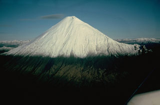
Geological Summary. The isolated Sangay volcano, located east of the Andean crest, is the southernmost of Ecuador's volcanoes and its most active. The steep-sided, glacier-covered, dominantly andesitic volcano grew within the open calderas of two previous edifices which were destroyed by collapse to the east, producing large debris avalanches that reached the Amazonian lowlands. The modern edifice dates back to at least 14,000 years ago. It towers above the tropical jungle on the east side; on the other sides flat plains of ash have been eroded by heavy rains into steep-walled canyons up to 600 m deep. The earliest report of an eruption was in 1628. Almost continuous eruptions were reported from 1728 until 1916, and again from 1934 to the present. The almost constant activity has caused frequent changes to the morphology of the summit crater complex.

