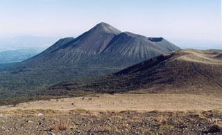
Report on Kirishimayama (Japan) — 30 March-5 April 2011
Smithsonian Institution / US Geological Survey
Weekly Volcanic Activity Report, 30 March-5 April 2011
Managing Editor: Sally Sennert.
Please cite this report as:
Global Volcanism Program, 2011. Report on Kirishimayama (Japan) (Sennert, S, ed.). Weekly Volcanic Activity Report, 30 March-5 April 2011. Smithsonian Institution and US Geological Survey.
Kirishimayama
Japan
31.934°N, 130.862°E; summit elev. 1700 m
All times are local (unless otherwise noted)
Based on notifications from JMA and pilot observations, the Tokyo VAAC reported that during 3-4 April ash plumes from Kirishima's Shinmoe-dake (Shinmoe peak) rose to altitudes of 4.6-6.1 km (15,000-20,000 ft) a.s.l. and drifted E.
Geological Summary. Kirishimayama is a large group of more than 20 Quaternary volcanoes located north of Kagoshima Bay. The late-Pleistocene to Holocene dominantly andesitic group consists of stratovolcanoes, pyroclastic cones, maars, and underlying shield volcanoes located over an area of 20 x 30 km. The larger stratovolcanoes are scattered throughout the field, with the centrally located Karakunidake being the highest. Onamiike and Miike, the two largest maars, are located SW of Karakunidake and at its far eastern end, respectively. Holocene eruptions have been concentrated along an E-W line of vents from Miike to Ohachi, and at Shinmoedake to the NE. Frequent small-to-moderate explosive eruptions have been recorded since the 8th century.

