Report on Ambrym (Vanuatu) — 22 June-28 June 2011
Smithsonian Institution / US Geological Survey
Weekly Volcanic Activity Report, 22 June-28 June 2011
Managing Editor: Sally Sennert.
Please cite this report as:
Global Volcanism Program, 2011. Report on Ambrym (Vanuatu) (Sennert, S, ed.). Weekly Volcanic Activity Report, 22 June-28 June 2011. Smithsonian Institution and US Geological Survey.
Ambrym
Vanuatu
16.25°S, 168.12°E; summit elev. 1334 m
All times are local (unless otherwise noted)
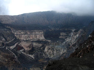
On 27 June, the Vanuatu Geohazards Observatory reported that data collected from Ambrym's monitoring network showed significant degassing daily and occasional explosions in the crater. Field observers noted that the level of the lava lakes was high. During June, villages reported minor ashfall and that acid rain affected vegetables in some areas W, S, and E. The Alert Level remained at 1 (on a scale of 0-4).
Geological Summary. Ambrym, a large basaltic volcano with a 12-km-wide caldera, is one of the most active volcanoes of the New Hebrides Arc. A thick, almost exclusively pyroclastic sequence, initially dacitic then basaltic, overlies lava flows of a pre-caldera shield volcano. The caldera was formed during a major Plinian eruption with dacitic pyroclastic flows about 1,900 years ago. Post-caldera eruptions, primarily from Marum and Benbow cones, have partially filled the caldera floor and produced lava flows that ponded on the floor or overflowed through gaps in the caldera rim. Post-caldera eruptions have also formed a series of scoria cones and maars along a fissure system oriented ENE-WSW. Eruptions have apparently occurred almost yearly during historical time from cones within the caldera or from flank vents. However, from 1850 to 1950, reporting was mostly limited to extra-caldera eruptions that would have affected local populations.
Source: Vanuatu Meteorology and Geohazards Department (VMGD)