Report on Katla (Iceland) — 6 July-12 July 2011
Smithsonian Institution / US Geological Survey
Weekly Volcanic Activity Report, 6 July-12 July 2011
Managing Editor: Sally Sennert.
Please cite this report as:
Global Volcanism Program, 2011. Report on Katla (Iceland) (Sennert, S, ed.). Weekly Volcanic Activity Report, 6 July-12 July 2011. Smithsonian Institution and US Geological Survey.
Katla
Iceland
63.633°N, 19.083°W; summit elev. 1490 m
All times are local (unless otherwise noted)
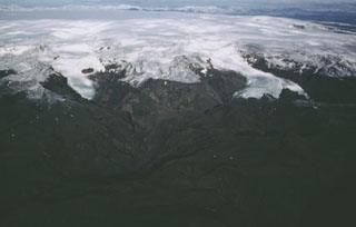
The Iceland Met Office and news sources reported that on 9 July a jökulhlaup from Myrdalsjökull, the ice sheet that covers Katla, originated from three ice cauldrons in the SE part of the caldera. During previous weeks microseismicity had been registered near several of the ice cauldrons. Around the time of peak harmonic tremor, in the early evening on 8 July, the Myrdalsjökull flood monitoring system indicated increased conduction. The water level reached the bridge around midnight and damaged the sensors. According to news articles, one new cauldron that had formed, along with cracks in the glacier around the cauldrons, may have been caused by a small eruption at Katla although no evidence of an eruption was observed. The jökulhlaup had destroyed a 128-m-long bridge and caused damage, resulting in the closing of part of the Ring Road. About 200 people were evacuated from the area but allowed to return home later that day. On 10 July the water had subsided and returned to normal levels.
Geological Summary. Katla volcano, located near the southern end of Iceland's eastern volcanic zone, is hidden beneath the Myrdalsjökull icecap. The subglacial basaltic-to-rhyolitic volcano is one of Iceland's most active and is a frequent producer of damaging jökulhlaups, or glacier-outburst floods. A large 10 x 14 km subglacial caldera with a long axis in a NW-SE direction is up to 750 m deep. Its high point reaches 1380 m, and three major outlet glaciers have breached its rim. Although most recorded eruptions have taken place from fissures inside the caldera, the Eldgjá fissure system, which extends about 60 km to the NE from the current ice margin towards Grímsvötn volcano, has been the source of major Holocene eruptions. An eruption from the Eldgjá fissure system about 934 CE produced a voluminous lava flow of about 18 km3, one of the world's largest known Holocene lava flows. Katla has been the source of frequent subglacial basaltic explosive eruptions that have been among the largest tephra-producers in Iceland during historical time and has also produced numerous dacitic explosive eruptions during the Holocene.
Sources: Morgunbladid News, Icelandic Meteorological Office (IMO), Iceland Review, Iceland Review, Iceland Review