Report on Ijen (Indonesia) — 14 December-20 December 2011
Smithsonian Institution / US Geological Survey
Weekly Volcanic Activity Report, 14 December-20 December 2011
Managing Editor: Sally Sennert.
Please cite this report as:
Global Volcanism Program, 2011. Report on Ijen (Indonesia) (Sennert, S, ed.). Weekly Volcanic Activity Report, 14 December-20 December 2011. Smithsonian Institution and US Geological Survey.
Ijen
Indonesia
8.058°S, 114.242°E; summit elev. 2769 m
All times are local (unless otherwise noted)
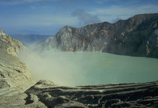
CVGHM reported that during 1 October-30 November white plumes from Ijen rose 50-150 m above the crater and lake water temperatures ranged from 26 to 31.6 degrees Celsius. During 1-14 December brownish-white plumes rose 50-200 m above the crater. The lake water temperature was 26.8 and 34.2 degrees Celsius on 8 and 14 December, respectively. Based on increased seismicity, visual observations, and lake water temperature increases, CVGHM raised the Alert Level from 1 to 2 (on a scale of 1-4). During 15-17 December seismicity significantly increased and sulfur dioxide gas emissions around the lake also increased. On 17 December the color of the lake water changed from light green to white. The Alert Level was raised to 3 the next day.
Geological Summary. The Ijen volcano complex at the eastern end of Java consists of a group of small stratovolcanoes constructed within the 20-km-wide Ijen (Kendeng) caldera. The north caldera wall forms a prominent arcuate ridge, but elsewhere the rim was buried by post-caldera volcanoes, including Gunung Merapi, which forms the high point of the complex. Immediately west of the Gunung Merapi stratovolcano is the historically active Kawah Ijen crater, which contains a nearly 1-km-wide, turquoise-colored, acid lake. Kawah Ijen is the site of a labor-intensive mining operation in which baskets of sulfur are hand-carried from the crater floor. Many other post-caldera cones and craters are located within the caldera or along its rim. The largest concentration of cones forms an E-W zone across the southern side of the caldera. Coffee plantations cover much of the caldera floor; nearby waterfalls and hot springs are tourist destinations.
Source: Pusat Vulkanologi dan Mitigasi Bencana Geologi (PVMBG, also known as CVGHM)

