Report on Tongariro (New Zealand) — 8 August-14 August 2012
Smithsonian Institution / US Geological Survey
Weekly Volcanic Activity Report, 8 August-14 August 2012
Managing Editor: Sally Sennert.
Please cite this report as:
Global Volcanism Program, 2012. Report on Tongariro (New Zealand) (Sennert, S, ed.). Weekly Volcanic Activity Report, 8 August-14 August 2012. Smithsonian Institution and US Geological Survey.
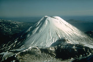
Tongariro
New Zealand
39.157°S, 175.632°E; summit elev. 1978 m
All times are local (unless otherwise noted)
GeoNet reported that favorable weather allowed GNS Science and Department of Conservation scientists to conduct an observation flight over Tongariro on 8 August. They noted actively steaming vents that were visible at a new crater area formed on 6 August below the Upper Te Mari crater, but low clouds prevented any views above this elevation. Blocks of old and hydrothermally altered lava, as large as 1 m in diameter, ejected by the eruption fell 1.5-2 km from the Te Mari craters area. Falling blocks formed impact craters in the ground in an extensive area to the E and W of the new vents. Most blocks were covered by grey ash but many on the W slopes were not, suggesting that they were ejected after the main ash-producing phase of the eruption.
The scientists also noted that previously steaming ground at Ketetahi and Lower Te Mari crater appeared more vigorous, but there were no obvious major changes. A debris flow generated by the eruption partly filled a stream valley draining N-W from the Upper Te Mari crater area. The deposit had blocked some stream tributaries but most water diverted around the edges. Ash had slumped from the banks into the stream valley, and in other stream valleys ash has been re-mobilized in slurry flows. No lahars were generated by the eruption.
New rock falls were visible around the walls of the new vent area and Lower Te Mari craters and in some stream valley walls near the craters. This suggested that significant ground shaking took place during the eruption. The Alert Level remained at 2 (on a scale of 0-5) and the Aviation Colour Code was lowered to Yellow (second lowest on a four-color scale).
During 8-9 August seismic activity remained at a low level; only a few small events were recorded. Preliminary analysis of the ash showed that there was little to no new magma erupted. Gas analysis on 9 August revealed emissions around 2,100 tonnes per day of sulfur dioxide, 3,900 tonnes per day of carbon dioxide, and 364 tonnes per day of hydrogen sulfide, confirming the presence of magma below the volcano. [Steam vents were clearly visible during a 10 August overflight; a very minor amount of ash was reported from some of those vents.] [On 17 August GeoNet noted that although very minor amounts of ash were emitted in the first few days after the eruption, there had been no significant activity since 6 August.] Seismicity continued to remain low during 10-14 August. Heavy rains on 12 August caused a lahar to cross State Highway 46, approximately 6 km W of Rangipo.
Geological Summary. Tongariro is a large volcanic massif, located immediately NE of Ruapehu volcano, that is composed of more than a dozen composite cones constructed over a period of 275,000 years. Vents along a NE-trending zone extending from Saddle Cone (below Ruapehu) to Te Maari crater (including vents at the present-day location of Ngauruhoe) were active during several hundred years around 10,000 years ago, producing the largest known eruptions at the Tongariro complex during the Holocene. North Crater stratovolcano is truncated by a broad, shallow crater filled by a solidified lava lake that is cut on the NW side by a small explosion crater. The youngest cone, Ngauruhoe, is also the highest peak.
Source: GeoNet