Report on Little Sitkin (United States) — 29 August-4 September 2012
Smithsonian Institution / US Geological Survey
Weekly Volcanic Activity Report, 29 August-4 September 2012
Managing Editor: Sally Sennert.
Please cite this report as:
Global Volcanism Program, 2012. Report on Little Sitkin (United States) (Sennert, S, ed.). Weekly Volcanic Activity Report, 29 August-4 September 2012. Smithsonian Institution and US Geological Survey.
Little Sitkin
United States
51.95°N, 178.543°E; summit elev. 1174 m
All times are local (unless otherwise noted)
AVO reported that at approximately 1915 on 29 August a swarm of high-frequency earthquakes was detected at Little Sitkin. The anomalous seismic activity continued through the night, prompting AVO to raise the Aviation Color Code to Yellow and the Volcano Alert Level to Advisory. The rate of anomalous seismicity varied during 30-31 August; the two most active periods were during the morning of 30 August and at about 0400 on 31 August. The rate of earthquakes started to decline at around 0600 on 31 August, but remained elevated through 3 September. Little Sitkin is monitored by a four-station seismic network as well as satellite imagery.
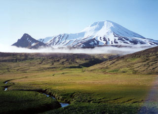
Geological Summary. Diamond-shaped Little Sitkin Island is bounded by steep cliffs on the east, north, and NE sides. Little Sitkin volcano contains two nested calderas. The older, nearly circular Pleistocene caldera is 4.8 km wide, may have once contained a caldera lake, and was partially filled by a younger cone formed mostly of andesitic and dacitic lava flows. The elliptical younger caldera is 2.7 x 4 km wide; it lies within the eastern part of the older caldera and shares its eastern and southern rim. The younger caldera partially destroyed the lava cone within the first caldera and is of possible early Holocene age. Young-looking dacitic lava flows, erupted in 1828 (Kay, in Wood and Kienle 1990), issued from the central cone within the younger caldera and from a vent on the west flank outside the older caldera. Fumarolic areas are found near the western coast, along the NW margin of the older caldera, and from the summit crater down the southern flank for a 1 km distance.
Source: US Geological Survey Alaska Volcano Observatory (AVO)