Report on Lokon-Empung (Indonesia) — 3 April-9 April 2013
Smithsonian Institution / US Geological Survey
Weekly Volcanic Activity Report, 3 April-9 April 2013
Managing Editor: Sally Sennert.
Please cite this report as:
Global Volcanism Program, 2013. Report on Lokon-Empung (Indonesia) (Sennert, S, ed.). Weekly Volcanic Activity Report, 3 April-9 April 2013. Smithsonian Institution and US Geological Survey.
Lokon-Empung
Indonesia
1.3644°N, 124.7992°E; summit elev. 1580 m
All times are local (unless otherwise noted)
Based on both CVGHM and ground reports, the Darwin VAAC reported that on 3 April an eruption from Lokon-Empung produced an ash plume that rose to altitudes of 3-3.4 km (10,000-11,000 ft) a.s.l. and drifted S and SE. On 8 April an ash plume rose to an altitude of 4.6 km (15,000 ft) a.s.l. and drifted SW. Ash was not detected in satellite imagery.
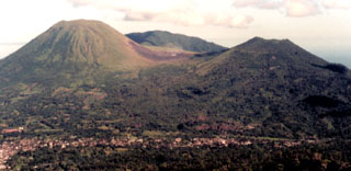
Geological Summary. The Lokong-Empung volcanic complex, rising above the plain of Tondano in North Sulawesi, includes four peaks and an active crater. Lokon, the highest peak, has a flat craterless top. The morphologically younger Empung cone 2 km NE has a 400-m-wide, 150-m-deep crater that erupted last in the 18th century. A ridge extending 3 km WNW from Lokon includes the Tatawiran and Tetempangan peaks. All eruptions since 1829 have originated from Tompaluan, a 150 x 250 m crater in the saddle between Lokon and Empung. These eruptions have primarily produced small-to-moderate ash plumes that sometimes damaged croplands and houses, but lava-dome growth and pyroclastic flows have also occurred.