Report on Guntur (Indonesia) — 28 August-3 September 2013
Smithsonian Institution / US Geological Survey
Weekly Volcanic Activity Report, 28 August-3 September 2013
Managing Editor: Sally Sennert.
Please cite this report as:
Global Volcanism Program, 2013. Report on Guntur (Indonesia) (Sennert, S, ed.). Weekly Volcanic Activity Report, 28 August-3 September 2013. Smithsonian Institution and US Geological Survey.
Guntur
Indonesia
7.143°S, 107.841°E; summit elev. 2251 m
All times are local (unless otherwise noted)
CVGHM reported that the number of deep and shallow volcanic earthquakes at Guntur increased during 15-21 August; seismicity declined after that period. On 30 August at 0820 seismicity again increased, characterized by continuous tremor that lasted until 1450. At 1600 CVGHM raised the Alert Level to 2 (on a scale of 1-4) and reminded residents and visitors not to approach the active crater within a 2-km radius.
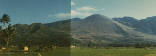
Geological Summary. Guntur is a complex of several overlapping stratovolcanoes about 10 km NW of the city of Garut in western Java. Young lava flows, the most recent of which was erupted in 1840, are visible on the flanks of the erosionally unmodified Gunung Guntur, which rises about 1550 m above the plain of Garut. It is one of a group of younger cones constructed to the SW of an older eroded group of volcanoes at the NE end of the complex. Guntur, whose name means "thunder," is the only center with recorded activity, with eruptions since the late-17th century. Although it produced frequent explosive eruptions in the 19th century, it has not erupted since.
Source: Pusat Vulkanologi dan Mitigasi Bencana Geologi (PVMBG, also known as CVGHM)