Report on Slamet (Indonesia) — 26 March-1 April 2014
Smithsonian Institution / US Geological Survey
Weekly Volcanic Activity Report, 26 March-1 April 2014
Managing Editor: Sally Sennert.
Please cite this report as:
Global Volcanism Program, 2014. Report on Slamet (Indonesia) (Sennert, S, ed.). Weekly Volcanic Activity Report, 26 March-1 April 2014. Smithsonian Institution and US Geological Survey.
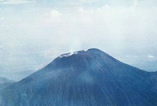
Slamet
Indonesia
7.242°S, 109.208°E; summit elev. 3428 m
All times are local (unless otherwise noted)
PVMBG reported that during 8-14 March dense white plumes rose as high as 1.2 km above Slamet, and ash plumes rose 800-1,000 m and drifted E. Incandescence from the crater was observed at 2148 during an eruption on 14 March. Brownish-white plumes rose 2 km on 15 March and ash plumes rose 1.2 km and again drifted E. During 22-28 March white-to-gray plumes rose 1.3 km. Dense gray ash plumes rose 2 km and drifted W. White plumes were observed on 29 March. Various seismic signals including shallow volcanic earthquakes, harmonic tremor, and volcanic earthquakes fluctuated during 8-28 March. Carbon dioxide emissions significantly increased during 17-20 March. PVMBG noted that activity, based on visual and instrument monitoring, continued to fluctuate; on 29 March the Alert Level remained at 2 (on a scale of 1-4). Residents and tourists were warned not approach the crater within a radius of 2 km.
Geological Summary. Slamet is one of Java's most active volcanoes. It has a cluster of about three dozen cinder cones on its lower SE-NE flanks and a single cinder cone on the W flank. It is composed of two overlapping edifices, an older basaltic andesite to andesitic volcano on the west and a younger basaltic to basaltic andesite one on the east. Gunung Malang II cinder cone on the upper E flank on the younger edifice fed a lava flow that extends 6 km E. Four craters occur at the summit of Gunung Slamet, with activity migrating to the SW over time. Eruptions recorded since the 18th century have originated from a 150-m-deep, 450-m-wide, steep-walled crater at the western part of the summit and have consisted of explosive eruptions generally lasting a few days to a few weeks.
Source: Pusat Vulkanologi dan Mitigasi Bencana Geologi (PVMBG, also known as CVGHM)