Report on Ubinas (Peru) — 26 March-1 April 2014
Smithsonian Institution / US Geological Survey
Weekly Volcanic Activity Report, 26 March-1 April 2014
Managing Editor: Sally Sennert.
Please cite this report as:
Global Volcanism Program, 2014. Report on Ubinas (Peru) (Sennert, S, ed.). Weekly Volcanic Activity Report, 26 March-1 April 2014. Smithsonian Institution and US Geological Survey.
Ubinas
Peru
16.345°S, 70.8972°W; summit elev. 5608 m
All times are local (unless otherwise noted)
IGP's Observatorio Volcanologico de Arequipa (IGP-OVA) reported that volcanologists visiting Ubinas on 19 March observed that lava had continued erupt, covering the 120-m-wide crater floor. Seismic signals detected during 20-21 and 23 March indicating increased lava emissions. Gas-and-ash plumes rose as high as 1.3 km above the crater almost daily during 10-25 March; ashfall was reported on 25 March in nearby villages and noises from the volcano were audible in areas as far as 6 km SE.
INGEMMET reported that on 26 March gas-and-ash emissions rose 1.2-1.7 km and drifted NE, E, and SW. Small amounts of fine ash fell within 4 km of the crater. Ash emissions on 27 March caused ashfall in Ubinas (6.5 km SSE), Querapi (4 km S), and Tonohaya (7 km SSE). Rockslides traveled down the SE flank. On 28 March residents of Ubinas reported noises from the volcano. Seismicity increased the next day and was characterized by long-period earthquakes and harmonic tremor. On 30 March gas-and-steam plumes rose as high as 1.2 km. A news article stated that residents of Querapi had started to evacuate. A low-energy explosion occurred at 0743 on 31 March and produced an ash plume that rose 1.2 km. More low-energy explosions followed: at 1119, 1306, 1518, and 1616. The explosions produced ash plumes that rose 1-1.8 km. Ashfall was reported in Ubinas and Querapi.
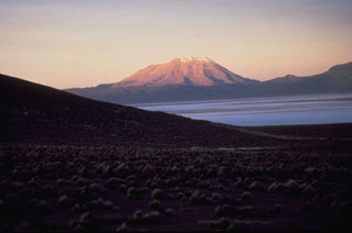
Geological Summary. The truncated appearance of Ubinas, Perú's most active volcano, is a result of a 1.4-km-wide crater at the summit. It is the northernmost of three young volcanoes located along a regional structural lineament about 50 km behind the main volcanic front. The growth and destruction of Ubinas I was followed by construction of Ubinas II beginning in the mid-Pleistocene. The upper slopes of the andesitic-to-rhyolitic Ubinas II stratovolcano are composed primarily of andesitic and trachyandesitic lava flows and steepen to nearly 45°. The steep-walled, 150-m-deep summit crater contains an ash cone with a 500-m-wide funnel-shaped vent that is 200 m deep. Debris-avalanche deposits from the collapse of the SE flank about 3,700 years ago extend 10 km from the volcano. Widespread Plinian pumice-fall deposits include one from about 1,000 years ago. Holocene lava flows are visible on the flanks, but activity documented since the 16th century has consisted of intermittent minor-to-moderate explosive eruptions.
Sources: Instituto Geológico Minero y Metalúrgico (INGEMMET), La República, Instituto Geofísico del Perú (IGP)

