Report on Ahyi (United States) — 30 April-6 May 2014
Smithsonian Institution / US Geological Survey
Weekly Volcanic Activity Report, 30 April-6 May 2014
Managing Editor: Sally Sennert.
Please cite this report as:
Global Volcanism Program, 2014. Report on Ahyi (United States) (Sennert, S, ed.). Weekly Volcanic Activity Report, 30 April-6 May 2014. Smithsonian Institution and US Geological Survey.
Ahyi
United States
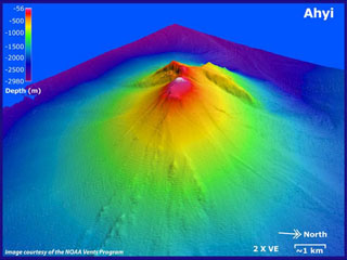
20.42°N, 145.03°E; summit elev. -75 m
All times are local (unless otherwise noted)
Seismic stations on Pagan, Sarigan, Anatahan, and Saipan started recording signals on 24 April that continued at least through 2 May. The source had not been confirmed, but is thought to be at or near the Ahyi seamount. During 4-5 May a helicorder plot from a station on Pagan showed explosive signals at a rate of 20 per hour.
Geological Summary. Ahyi seamount is a large conical submarine volcano that rises to within 75 m of the ocean surface ~18 km SE of the island of Farallon de Pajaros in the northern Marianas. Water discoloration has been observed there, and in 1979 the crew of a fishing boat felt shocks over the summit area, followed by upwelling of sulfur-bearing water. On 24-25 April 2001 an explosive eruption was detected seismically by a station on Rangiroa Atoll, Tuamotu Archipelago. The event was well constrained (+/- 15 km) at a location near the southern base of Ahyi. An eruption in April-May 2014 was detected by NOAA divers, hydroacoustic sensors, and seismic stations.
Sources: Emergency Management Office of the Commonwealth of the Mariana Islands and United States Geological Survey Volcano Hazards Program, Matthew Haney, Alaska Volcano Observatory via Bill Chadwick, Oregon State University's Marine Science Center and NOAA/PMEL EOI Program, personal communication