
Smithsonian Institution / US Geological Survey
Weekly Volcanic Activity Report, 16 September-22 September 2015
Managing Editor: Sally Sennert
Please cite this report as:
Global Volcanism Program, 2015. Report on Mauna Loa (United States) (Sennert, S, ed.). Weekly Volcanic Activity Report, 16 September-22 September 2015. Smithsonian Institution and US Geological Survey. https://volcano.si.edu/showreport.cfm?gvpvar=GVP.WVAR20150916-332020
On 18 September HVO reported that for at least the previous year the seismic network at Mauna Loa detected elevated seismicity beneath the summit, upper Southwest Rift Zone, and W flank; the rate of these shallow earthquakes varied but overall had remained above the long-term average. The earthquakes locations were similar to those preceding recent eruptions in 1975 and 1984, although the magnitudes were comparatively low. In addition, ground deformation consistent with recharge of the volcano’s shallow magma storage system was also detected during the previous year. The rate and pattern of the deformation was similar to that measured during a period of inflation 2005, unrest that did not lead to an eruption. However, since the observations indicated that Mauna Loa is no longer at background levels, HVO raised the Aviation Color Code to Yellow and the Volcano Alert Level to Advisory.
Source: US Geological Survey Hawaiian Volcano Observatory (HVO)
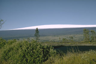
Geological Summary. Massive Mauna Loa is a basaltic shield volcano that rises almost 9 km from the ocean floor to form the world's largest Holocene volcano. Flank eruptions typically occur from the lengthy NE and SW rift zones, and from the Mokuʻāweoweo summit is caldera, which is within an older and larger 6 x 8 km caldera. Two large debris avalanches traveled nearly 100 km; the second of the Alika avalanches was emplaced about 105,000 years ago (Moore et al., 1989). Almost 90% of the surface of the volcano is covered by lavas less than 4,000 years old (Lockwood and Lipman, 1987). Beginning about 1,500 years ago, a series of voluminous overflows from a summit lava lake covered about 25% of the volcano's surface. Over the last 750 years, from shortly after the formation of Mokuʻāweoweo caldera until the present, an additional 25% of the volcano has been covered with lava flows, mainly from summit and NW rift zone vents.


 Mauna Loa