Report on Iya (Indonesia) — 28 September-4 October 2016
Smithsonian Institution / US Geological Survey
Weekly Volcanic Activity Report, 28 September-4 October 2016
Managing Editor: Sally Sennert.
Please cite this report as:
Global Volcanism Program, 2016. Report on Iya (Indonesia) (Sennert, S, ed.). Weekly Volcanic Activity Report, 28 September-4 October 2016. Smithsonian Institution and US Geological Survey.
Iya
Indonesia
8.891°S, 121.641°E; summit elev. 618 m
All times are local (unless otherwise noted)
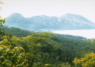
PVMBG reported that during 1 July-29 September variable-density white plumes rose as high as 150 m above Iya. During most of that period seismicity was at normal levels characterized by deep and shallow volcanic earthquakes each detected at a rate of less than 10 events per day. Between 1550 and 1800 on 29 September, however, the seismic network detected 17 volcanic earthquakes. Since the number of volcanic earthquakes was significant and above normal levels, the Alert Level was raised to 2 (on a scale of 1-4), and the public was warned not to approach the crater within a 2-km radius.
Geological Summary. Gunung Iya is the southernmost of a group of three volcanoes comprising a small peninsula south of the city of Ende on central Flores Island. The cones to the north, Rooja and Pui, appear to be slightly older and have not shown historical activity, although Pui has a youthful profile (a reported 1671 eruption of Pui was considered to have originated from Iya volcano). Iya, whose truncated southern side drops steeply to the sea, has had numerous moderate explosive eruptions during historical time.
Source: Pusat Vulkanologi dan Mitigasi Bencana Geologi (PVMBG, also known as CVGHM)