Report on Kambalny (Russia) — 12 April-18 April 2017
Smithsonian Institution / US Geological Survey
Weekly Volcanic Activity Report, 12 April-18 April 2017
Managing Editor: Sally Sennert.
Please cite this report as:
Global Volcanism Program, 2017. Report on Kambalny (Russia) (Sennert, S, ed.). Weekly Volcanic Activity Report, 12 April-18 April 2017. Smithsonian Institution and US Geological Survey.
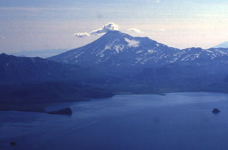
Kambalny
Russia
51.306°N, 156.875°E; summit elev. 2116 m
All times are local (unless otherwise noted)
KVERT reported that observers in the South Kamchatka Sanctuary noted an ash plume from Kambalny rising to an altitude of 7 km (23,000 ft) a.s.l. on 9 April. Ash plumes identified in satellite images drifted 50 km NE on 9 April and about 170 km SE the next day. The Aviation Color Code remained at Orange.
Geological Summary. The southernmost major stratovolcano on the Kamchatka peninsula, Kambalny has a summit crater that is breached to the SE. Five Holocene cinder cones on the W and SE flanks have produced fresh-looking lava flows. Beginning about 6,300 radiocarbon years ago, a series of major collapses of the edifice produced at least three debris-avalanche deposits. The last major eruption took place about 600 years ago, although younger tephra layers have been found, and an eruption was reported in 1767. Active fumarolic areas are found on the flanks of the volcano, which is located south of the massive Pauzhetka volcano-tectonic depression.