Report on Kadovar (Papua New Guinea) — 7 February-13 February 2018
Smithsonian Institution / US Geological Survey
Weekly Volcanic Activity Report, 7 February-13 February 2018
Managing Editor: Sally Sennert.
Please cite this report as:
Global Volcanism Program, 2018. Report on Kadovar (Papua New Guinea) (Sennert, S, ed.). Weekly Volcanic Activity Report, 7 February-13 February 2018. Smithsonian Institution and US Geological Survey.
Kadovar
Papua New Guinea
3.608°S, 144.588°E; summit elev. 365 m
All times are local (unless otherwise noted)
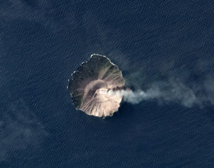
RVO reported that on 9 February the lava dome at Kadovar’s SE Coastal Vent collapsed, causing 5-6 minor tsunamis, less than 1 m high, observed by residents on Blup Blup’s E and W coasts. The waves were reported at 1050, before the main collapse of the dome. In a 12 February report RVO noted that activity from Main Crater consisted of white plumes rising 20 m and drifting a few kilometers SE and weak nighttime crater incandescence.
Geological Summary. The 2-km-wide island of Kadovar is the emergent summit of a Bismarck Sea stratovolcano of Holocene age. It is part of the Schouten Islands, and lies off the coast of New Guinea, about 25 km N of the mouth of the Sepik River. Prior to an eruption that began in 2018, a lava dome formed the high point of the andesitic volcano, filling an arcuate landslide scarp open to the south; submarine debris-avalanche deposits occur in that direction. Thick lava flows with columnar jointing forms low cliffs along the coast. The youthful island lacks fringing or offshore reefs. A period of heightened thermal phenomena took place in 1976. An eruption began in January 2018 that included lava effusion from vents at the summit and at the E coast.
Source: Rabaul Volcano Observatory (RVO)