Report on Ebeko (Russia) — 8 August-14 August 2018
Smithsonian Institution / US Geological Survey
Weekly Volcanic Activity Report, 8 August-14 August 2018
Managing Editor: Sally Sennert.
Please cite this report as:
Global Volcanism Program, 2018. Report on Ebeko (Russia) (Sennert, S, ed.). Weekly Volcanic Activity Report, 8 August-14 August 2018. Smithsonian Institution and US Geological Survey.
Ebeko
Russia
50.686°N, 156.014°E; summit elev. 1103 m
All times are local (unless otherwise noted)
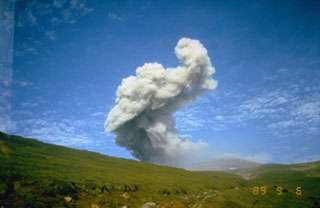
Volcanologists in Severo-Kurilsk (Paramushir Island), about 7 km E of Ebeko, observed explosions during 3-10 August that sent ash plumes as high as 3.7 km (12,100 ft) a.s.l. An ash cloud identified in satellite data drifted about 65 km E during 7-8 August. The Aviation Color Code remained at Orange (the second highest level on a four-color scale).
Geological Summary. The flat-topped summit of the central cone of Ebeko volcano, one of the most active in the Kuril Islands, occupies the northern end of Paramushir Island. Three summit craters located along a SSW-NNE line form Ebeko volcano proper, at the northern end of a complex of five volcanic cones. Blocky lava flows extend west from Ebeko and SE from the neighboring Nezametnyi cone. The eastern part of the southern crater contains strong solfataras and a large boiling spring. The central crater is filled by a lake about 20 m deep whose shores are lined with steaming solfataras; the northern crater lies across a narrow, low barrier from the central crater and contains a small, cold crescentic lake. Historical activity, recorded since the late-18th century, has been restricted to small-to-moderate explosive eruptions from the summit craters. Intense fumarolic activity occurs in the summit craters, on the outer flanks of the cone, and in lateral explosion craters.