Report on Westdahl (United States) — 14 October-20 October 2020
Smithsonian Institution / US Geological Survey
Weekly Volcanic Activity Report, 14 October-20 October 2020
Managing Editor: Sally Sennert.
Please cite this report as:
Global Volcanism Program, 2020. Report on Westdahl (United States) (Sennert, S, ed.). Weekly Volcanic Activity Report, 14 October-20 October 2020. Smithsonian Institution and US Geological Survey.
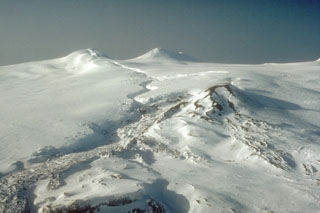
Westdahl
United States
54.516°N, 164.65°W; summit elev. 1563 m
All times are local (unless otherwise noted)
AVO reported that the seismic network at Westdahl has been re-established, again allowing seismic unrest at the volcano to be monitored. The Volcano Alert Level and Aviation Color Code were changed from Unassigned to Normal and Green, respectively, on 15 October.
Geological Summary. Westdahl is a broad glacier-covered volcano occupying the SW end of Unimak Island. Two peaks protrude from the summit plateau, and a new crater formed in 1978 cuts the summit icecap. The volcano has a somewhat of a shield-like morphology and forms one of the largest volcanoes of the Aleutian Islands. The sharp-topped, conical Pogromni stratovolcano, 6 km N, rises several hundred meters higher than Westdahl, but is moderately glacially dissected and presumably older. Many satellitic cones of postglacial age are located along a NW-SE line cutting across the summit of Westdahl. Some of the historical eruptions attributed to the eroded Pogromni may have originated instead from Westdahl (Miller et al. 1998). The first historical eruption occurred in 1795. An 8-km-long fissure extending east from the summit produced explosive eruptions and lava flows in 1991.
Source: US Geological Survey Alaska Volcano Observatory (AVO)