Report on Chirinkotan (Russia) — 4 August-10 August 2021
Smithsonian Institution / US Geological Survey
Weekly Volcanic Activity Report, 4 August-10 August 2021
Managing Editor: Sally Sennert.
Please cite this report as:
Global Volcanism Program, 2021. Report on Chirinkotan (Russia) (Sennert, S, ed.). Weekly Volcanic Activity Report, 4 August-10 August 2021. Smithsonian Institution and US Geological Survey.
Chirinkotan
Russia
48.98°N, 153.48°E; summit elev. 724 m
All times are local (unless otherwise noted)
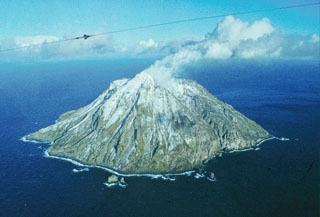
According to KVERT an explosion at Chirinkotan at 1745 on 8 August produced an ash plume that rose 2-2.7 km (6,600-9,000 ft) a.s.l. and drifted 86 km WSW and SW. KVERT raised the Aviation Color Code to Orange (the second highest level on a four-color scale). KVERT, SVERT, and the VAAC reported continuing ash-producing events through 10 August. Notably at 1915 on 9 August an ash cloud, 10 x 13 km in size, possibly rose as high as 3.7 km (12,000 ft) a.s.l. and drifted 26-30 km SSE and S. An explosive event at 0855 on 10 August produced an ash plume 11 x 14 km in size that rose 2-2.5 km (6,600-8,200 ft) a.s.l. and drifted 70 km W.
Geological Summary. The small, mostly unvegetated 3-km-wide island of Chirinkotan occupies the far end of an E-W volcanic chain that extends nearly 50 km W of the central part of the main Kuril Islands arc. It is the emergent summit of a volcano that rises 3000 m from the floor of the Kuril Basin. A small 1-km-wide caldera about 300-400 m deep is open to the SW. Lava flows from a cone within the breached crater reached the shore of the island. Historical eruptions have been recorded since the 18th century. Lava flows were observed by the English fur trader Captain Snow in the 1880s.
Sources: Kamchatkan Volcanic Eruption Response Team (KVERT), Sakhalin Volcanic Eruption Response Team (SVERT), Tokyo Volcanic Ash Advisory Center (VAAC)