Report on La Palma (Spain) — 8 September-14 September 2021
Smithsonian Institution / US Geological Survey
Weekly Volcanic Activity Report, 8 September-14 September 2021
Managing Editor: Sally Sennert.
Please cite this report as:
Global Volcanism Program, 2021. Report on La Palma (Spain) (Sennert, S, ed.). Weekly Volcanic Activity Report, 8 September-14 September 2021. Smithsonian Institution and US Geological Survey.
La Palma
Spain
28.57°N, 17.83°W; summit elev. 2426 m
All times are local (unless otherwise noted)
Instituto Geográfico Nacional (IGN) and Instituto Volcanológico de Canarias (INVOLCAN) reported that a seismic swarm beneath Cumbre Vieja at the S part of La Palma began at 1618 on 11 September and was likely associated with a magmatic intrusion. The swarm intensified in number of events and magnitude, and by 1600 on 12 September a total of 315 earthquakes had been recorded and ranged 8-13 km in depth. The largest event was a M 2.8 (on the Mb_lg scale). On 13 September a scientific committee comprised of representatives from multiple agencies and institutions raised the Alert Level to Yellow (the second lowest level on a four-color scale) for the municipalities of El Paso, Los Llanos de Aridane, Mazo, and Fuencaliente de la Palma. By 0800 on 14 September 2,935 earthquakes had been detected. Larger events were felt by residents during 13-14 September; the largest earthquake was a M 3.9, recorded at 0600 on 14 September. Overall, the events were becoming shallower (8-10 km) and hypocenters migrated slightly to the W. GPS and tiltmeter networks showed deformation totaling 1.5 cm centered over the clusters of epicenters.
A total of 10 seismic swarms have been detected at La Palma since 2017; one in 2017, one in 2018, five in 2020, and three in 2021. The earthquakes in the previous swarms were deeper, between 20 and 30 km, and were less intense than the current swarm.
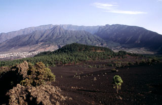
Geological Summary. The 47-km-long wedge-shaped island of La Palma, the NW-most of the Canary Islands, is composed of two large volcanic centers. The older northern one is cut by the steep-walled Caldera Taburiente, one of several massive collapse scarps produced by edifice failure to the SW. On the south, the younger Cumbre Vieja volcano is one of the most active in the Canaries. The elongated volcano dates back to about 125,000 years ago and is oriented N-S. Eruptions during the past 7,000 years have formed abundant cinder cones and craters along the axis, producing fissure-fed lava flows that descend steeply to the sea. Eruptions recorded since the 15th century have produced mild explosive activity and lava flows that damaged populated areas. The southern tip of the island is mantled by a broad lava field emplaced during the 1677-1678 eruption. Lava flows also reached the sea in 1585, 1646, 1712, 1949, 1971, and 2021.
Sources: Instituto Volcanológico de Canarias (INVOLCAN), Gobierno de Canarias, Instituto Geográfico Nacional (IGN)