Report on Fukutoku-Oka-no-Ba (Japan) — 27 October-2 November 2021
Smithsonian Institution / US Geological Survey
Weekly Volcanic Activity Report, 27 October-2 November 2021
Managing Editor: Sally Sennert.
Please cite this report as:
Global Volcanism Program, 2021. Report on Fukutoku-Oka-no-Ba (Japan) (Sennert, S, ed.). Weekly Volcanic Activity Report, 27 October-2 November 2021. Smithsonian Institution and US Geological Survey.
Fukutoku-Oka-no-Ba
Japan
24.285°N, 141.481°E; summit elev. -29 m
All times are local (unless otherwise noted)
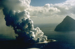
The Japan Coast Guard reported that floating pumice from the mid-August Fukutoku-Oka-no-Ba eruption had arrived at coastlines more than 1,000 kilometers away in early October. The pumice first arrived at Kitadaito Island (1,035 km W) on 8 October. In late October pumice circled Okinawa and Maejima islands (1,422 km W) and several ports in the Kagoshima prefecture (1,322 NW). The pumice damaged hundreds of boats and ships, clogged harbors, and impacted the fishing and tourism industries in several areas. Several local governments began the process of removing the pumice from the water.
Geological Summary. Fukutoku-Oka-no-ba is a submarine volcano located 5 km NE of the island of Minami-Ioto. Water discoloration is frequently observed, and several ephemeral islands have formed in the 20th century. The first of these formed Shin-Ioto ("New Sulfur Island") in 1904, and the most recent island was formed in 1986. The volcano is part of an elongated edifice with two major topographic highs trending NNW-SSE, and is a trachyandesitic volcano geochemically similar to Ioto.
Sources: Japan Coast Guard, The Japan Times, The Guardian News