Report on Fernandina (Ecuador) — 10 November-16 November 2021
Smithsonian Institution / US Geological Survey
Weekly Volcanic Activity Report, 10 November-16 November 2021
Managing Editor: Sally Sennert.
Please cite this report as:
Global Volcanism Program, 2021. Report on Fernandina (Ecuador) (Sennert, S, ed.). Weekly Volcanic Activity Report, 10 November-16 November 2021. Smithsonian Institution and US Geological Survey.
Fernandina
Ecuador
0.37°S, 91.55°W; summit elev. 1476 m
All times are local (unless otherwise noted)
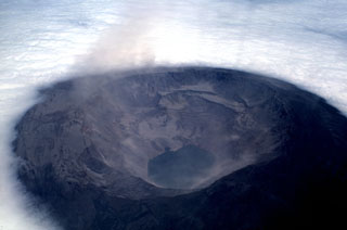
IG reported that slow deformation at Fernandina has been recorded over the previous 18 months. InSAR data showed that inflation was occurring at a rate of about 400 mm/year in the summit caldera and on the NE flank, while deflation was occurring at a rate of about 100-400 mm/year in areas on the upper W and SW flanks. On 13 October the areas of deflation changed to inflation and the rate of deformation in the caldera increased. On 17 November IG noted that fumarolic activity in the summit crater was visible during the previous few days and may have been related to a small episode of tremor on 16 November. IG also noted that periodic fumarolic activity and small episodes of tremor are common at Fernandina without an eruption.
Geological Summary. Fernandina, the most active of Galápagos volcanoes and the one closest to the Galápagos mantle plume, is a basaltic shield volcano with a deep 5 x 6.5 km summit caldera. The volcano displays the classic "overturned soup bowl" profile of Galápagos shield volcanoes. Its caldera is elongated in a NW-SE direction and formed during several episodes of collapse. Circumferential fissures surround the caldera and were instrumental in growth of the volcano. Reporting has been poor in this uninhabited western end of the archipelago, and even a 1981 eruption was not witnessed at the time. In 1968 the caldera floor dropped 350 m following a major explosive eruption. Subsequent eruptions, mostly from vents located on or near the caldera boundary faults, have produced lava flows inside the caldera as well as those in 1995 that reached the coast from a SW-flank vent. Collapse of a nearly 1 km3 section of the east caldera wall during an eruption in 1988 produced a debris-avalanche deposit that covered much of the caldera floor and absorbed the caldera lake.
Source: Instituto Geofísico-Escuela Politécnica Nacional (IG-EPN)

