Report on Papandayan (Indonesia) — 1 March-7 March 2023
Smithsonian Institution / US Geological Survey
Weekly Volcanic Activity Report, 1 March-7 March 2023
Managing Editor: Sally Sennert.
Please cite this report as:
Global Volcanism Program, 2023. Report on Papandayan (Indonesia) (Sennert, S, ed.). Weekly Volcanic Activity Report, 1 March-7 March 2023. Smithsonian Institution and US Geological Survey.
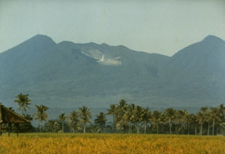
Papandayan
Indonesia
7.3175°S, 107.7306°E; summit elev. 2643 m
All times are local (unless otherwise noted)
PVMBG issued a special report based on recent observations of Papandayan. The number of shallow volcanic earthquakes had increased in January and although the numbers fluctuated, low-frequency earthquakes also increased overall during January and February. Webcam images from the camera in the parking area showed incandescence emanating from Kawah Baru during the night on 22 February. A team of PVMBG scientists inspected the crater during 2100-2300 on an unspecified date to identify the source of the incandescence. They observed intense emissions rising from Kawah Baru, heard faint rumbling, and detected a strong sulfur odor, but did not see incandescence. Gas plumes rose 300 m from a solfatara. The color of the lake in Kawah Baru was greenish. Rumbling sounds from both the Kawah Mas and Kawah Baru solfatara complexes varied from weak to strong and gas emissions were sometimes intense. Solfatara temperatures were variable at Kawah Mas, Kawah Manuk, and Kawah Baru with a maximum temperature of 123.8 degrees Celsius. Sulfur dioxide gas concentrations were high at a distance of 500 m from the solfatara complexes. Based on the field observations PVMBG concluded that conditions at Papandayan were relatively normal. The Alert Level remained at 1 (on a scale of 1-4) and tourists were advised to stay 500 m away from the active craters.
Geological Summary. Papandayan is a complex stratovolcano at the S end of a curved volcanic massif with Kendang volcano ~9 km away at the N end, Gunung Puntang ~3.5 km NNE, and Gunung Jaya ~6 km NNE. Several episodes of collapse have created an irregular profile and produced debris avalanches that have affected lowland areas. The summit area includes four large craters, including the 1.1-km-wide, flat-floored Alun-Alun crater. A sulfur-encrusted fumarole field occupies the active Kawah Mas ("Golden Crater"). The first reported eruption, in 1772 CE, included a collapse of the NE flank and a debris avalanche that destroyed 40 villages and killed almost 3,000 people. Smaller phreatic eruptions occurred during 1923-25, 1942, and 2002.
Source: Pusat Vulkanologi dan Mitigasi Bencana Geologi (PVMBG, also known as CVGHM)