Report on Taupo (New Zealand) — 24 May-30 May 2023
Smithsonian Institution / US Geological Survey
Weekly Volcanic Activity Report, 24 May-30 May 2023
Managing Editor: Sally Sennert.
Please cite this report as:
Global Volcanism Program, 2023. Report on Taupo (New Zealand) (Sennert, S, ed.). Weekly Volcanic Activity Report, 24 May-30 May 2023. Smithsonian Institution and US Geological Survey.
Taupo
New Zealand
38.7811°S, 175.893°E; summit elev. 760 m
All times are local (unless otherwise noted)
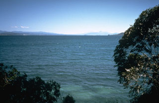
GeoNet reported that earthquake activity and ground deformation at Taupo declined during January-April and returned to background levels in May. The Volcanic Alert Level was lowered to 0 (the lowest level on a six-level scale) on 30 May and the Aviation Color Code remained at Green (the lowest level on a four-color scale). Unrest at the volcano started in early May 2022; during the year there were just over 1,800 earthquakes located beneath the volcano along with ground deformation both on the lake floor and around the lake.
Geological Summary. Taupo, the most active rhyolitic volcano of the Taupo volcanic zone, is a large, roughly 35-km-wide caldera with poorly defined margins. It is a type example of an "inverse volcano" that slopes inward towards the most recent vent location. The caldera, now filled by Lake Taupo, largely formed as a result of the voluminous eruption of the Oruanui Tephra about 22,600 years before present (BP). This was the largest known eruption at Taupo, producing about 1,170 km3 of tephra. This eruption was preceded during the late Pleistocene by the eruption of a large number of rhyolitic lava domes north of Lake Taupo. Large explosive eruptions have occurred frequently during the Holocene from many vents within Lake Taupo and near its margins. The most recent major eruption took place about 1,800 years BP from at least three vents along a NE-SW-trending fissure centered on the Horomotangi Reefs. This extremely violent eruption was New Zealand's largest during the Holocene and produced the thin but widespread phreatoplinian Taupo Ignimbrite, which covered 20,000 km2 of North Island.
Source: GeoNet