Report on Wrangell (United States) — 11 October-17 October 2023
Smithsonian Institution / US Geological Survey
Weekly Volcanic Activity Report, 11 October-17 October 2023
Managing Editor: Sally Sennert.
Please cite this report as:
Global Volcanism Program, 2023. Report on Wrangell (United States) (Sennert, S, ed.). Weekly Volcanic Activity Report, 11 October-17 October 2023. Smithsonian Institution and US Geological Survey.
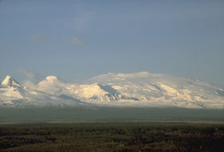
Wrangell
United States
62.006°N, 144.017°W; summit elev. 4278 m
All times are local (unless otherwise noted)
On 13 October AVO changed both the Aviation Color Code and the Volcano Alert Level for Wrangell to Unassigned because of a station outage and the inability to reliably detect unrest at the volcano. AVO will continue using satellite, regional infrasound, and lightning data, and reports from pilots and ground observers to detect signs of eruptive activity.
Geological Summary. Mount Wrangell is one of the world's largest continental-margin volcanoes, with a diameter of 30 km at 2,000 m elevation. The andesitic shield volcano has produced fluid lava flows as long as 58 km and contains an ice-filled caldera 4-6 km in diameter and 1 km deep, located within an older 15-km-wide caldera. Most of the edifice was constructed during eruptions between about 600,000 and 200,000 years ago. Formation of the summit caldera followed sometime between about 200,000 and 50,000 years ago. Three post-caldera craters are located at the broad summit, along the northern and western caldera rim. A steep-sided flank cinder cone, Mount Zanetti, is located 6 km NW of the summit. The westernmost cone has been the source of infrequent eruptions beginning in the 18th century. Increased heat flux in recent years has melted large volumes of ice in the northern crater.
Source: US Geological Survey Alaska Volcano Observatory (AVO)