Report on Erta Ale (Ethiopia) — 24 January-30 January 2024
Smithsonian Institution / US Geological Survey
Weekly Volcanic Activity Report, 24 January-30 January 2024
Managing Editor: Sally Sennert.
Please cite this report as:
Global Volcanism Program, 2024. Report on Erta Ale (Ethiopia) (Sennert, S, ed.). Weekly Volcanic Activity Report, 24 January-30 January 2024. Smithsonian Institution and US Geological Survey.
Erta Ale
Ethiopia
13.601°N, 40.666°E; summit elev. 585 m
All times are local (unless otherwise noted)
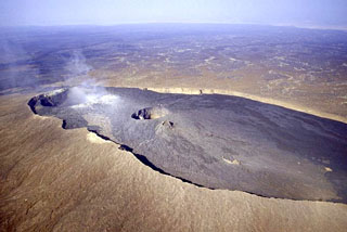
During 13-23 January lava flows emerged from vents in Erta Ale’s S pit crater and traveled about 500 m S, 200 m NW, and 250 m SSW based on satellite images. Visitors to the volcano took photographs and video of low lava fountaining at a cone and advancing pahoehoe flows. Activity increased notably during the morning of 27 January.
Geological Summary. The Erta Ale basaltic shield volcano in Ethiopia has a 50-km-wide edifice that rises more than 600 m from below sea level in the Danakil depression. The volcano includes a 0.7 x 1.6 km summit crater hosting steep-sided pit craters. Another larger 1.8 x 3.1 km wide depression elongated parallel to the trend of the Erta Ale range is located SE of the summit and is bounded by curvilinear fault scarps on the SE side. Basaltic lava flows from these fissures have poured into the caldera and locally overflowed its rim. The summit caldera usually also holds at least one long-term lava lake that has been active since at least 1967, and possibly since 1906. Recent fissure eruptions have occurred on the N flank.
Sources: Copernicus, Il Mondo dei Terremoti, Aventure et Volcans