Report on El Misti (Peru) — 24 January-30 January 2024
Smithsonian Institution / US Geological Survey
Weekly Volcanic Activity Report, 24 January-30 January 2024
Managing Editor: Sally Sennert.
Please cite this report as:
Global Volcanism Program, 2024. Report on El Misti (Peru) (Sennert, S, ed.). Weekly Volcanic Activity Report, 24 January-30 January 2024. Smithsonian Institution and US Geological Survey.
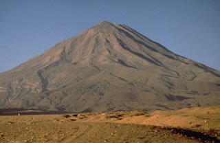
El Misti
Peru
16.2991°S, 71.4056°W; summit elev. 5793 m
All times are local (unless otherwise noted)
Instituto Geofísico del Perú (IGP) reported that lahars descended the SE flanks at El Misti at 1448 on 23 January and at 1642 on 25 January. The report noted that possible areas of impact included the Andamayo and Agua Salada river drainages in the Chiguata District. The public was warned to stay away from the drainages and roads on the SE flank.
Geological Summary. El Misti is a symmetrical andesitic stratovolcano with nested summit craters immediately NE of the city of Arequipa, Peru. Eruptions from the active cone began about 13,700 and 11,300 years ago, within a 1.5 x 2 km caldera that underwent collapse about 50,000 years ago. A large scoria cone has grown with the 830-m-wide outer summit crater. At least 20 tephra-fall deposits and numerous pyroclastic-flow deposits have been documented during the past 50,000 years, including a pyroclastic flow that traveled 12 km S about 2,000 years ago. The most recent activity has been dominantly pyroclastic, and strong winds have formed a parabolic dune field of volcanic ash extending up to 20 km downwind. An eruption in the 15th century affected nearby Inca inhabitants. Some reported eruptions may represent increased fumarolic activity.