Report on Taal (Philippines) — 24 April-30 April 2024
Smithsonian Institution / US Geological Survey
Weekly Volcanic Activity Report, 24 April-30 April 2024
Managing Editor: Sally Sennert.
Please cite this report as:
Global Volcanism Program, 2024. Report on Taal (Philippines) (Sennert, S, ed.). Weekly Volcanic Activity Report, 24 April-30 April 2024. Smithsonian Institution and US Geological Survey.
Taal
Philippines
14.0106°N, 120.9975°E; summit elev. 311 m
All times are local (unless otherwise noted)
PHIVOLCS reported ongoing unrest at Taal during 23-30 April. Upwelling gasses and hot fluids in the lake were visible during daily observations. Daily emissions of gas-and-steam rose from Main Crater Lake as high as 1.8 km, were sometimes voluminous, and drifted generally NW and SW. There were 0-14 daily earthquakes recorded by the seismic network including a few periods of volcanic tremor lasting 2-4 minutes. One phreatic event lasting two minutes long was recorded during 28-29 April. The Alert Level remained at 1 (on a scale of 0-5), and PHIVOLCS reminded the public that the entire Taal Volcano Island was a Permanent Danger Zone (PDZ) and to take extra precautions around Main Crater, when boating on Taal Lake, and along the Daang Kastila fissure.
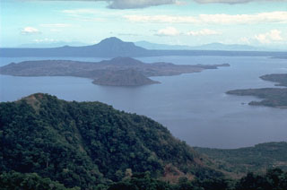
Geological Summary. Taal is one of the most active volcanoes in the Philippines and has produced some powerful eruptions. The 15 x 20 km Talisay (Taal) caldera is largely filled by Lake Taal, whose 267 km2 surface lies only 3 m above sea level. The maximum depth of the lake is 160 m, with several submerged eruptive centers. The 5-km-wide Volcano Island in north-central Lake Taal is the location of all observed eruptions. The island is composed of coalescing small stratovolcanoes, tuff rings, and scoria cones. Powerful pyroclastic flows and surges have caused many fatalities.
Source: Philippine Institute of Volcanology and Seismology (PHIVOLCS)

