Report on Spurr (United States) — 15 May-21 May 2024
Smithsonian Institution / US Geological Survey
Weekly Volcanic Activity Report, 15 May-21 May 2024
Managing Editor: Sally Sennert.
Please cite this report as:
Global Volcanism Program, 2024. Report on Spurr (United States) (Sennert, S, ed.). Weekly Volcanic Activity Report, 15 May-21 May 2024. Smithsonian Institution and US Geological Survey.
Spurr
United States
61.299°N, 152.251°W; summit elev. 3374 m
All times are local (unless otherwise noted)
On 15 May AVO reported that elevated seismicity at Spurr was consistent with an intrusion of magma deep beneath the volcano. An extended outage of the seismic network occurred during February-April; elevated seismicity was already occurring when the network returned on 3 April. An average of four earthquakes per day were located after that time, with a maximum of 33 earthquakes detected on 26 April. They were typically smaller than M 1 and were located near the summit and as deep as 30 km below sea level. This activity represents an increase in earthquake rate and occurrence of deeper (>20 km) low-frequency earthquakes compared to recent years. Minor uplift of the ground surface at the volcano of about 1 cm was detected in local GPS data beginning in November 2023, which was a deviation from the long-term trend and may be related to the seismicity. Minor steaming from fumaroles in the summit crater area was sometimes visible; no notable changes to the ice-and-snow cover or gas-and-steam emissions were observed in association with these geophysical observations. A short observational flight was conducted on 14 May. The Volcano Alert Level remained at Normal (the lowest level on a four-level scale) and the Aviation Color Code remained at Green (the lowest color on a four-color scale).
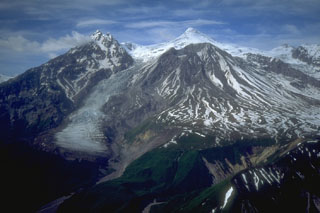
Geological Summary. Mount Spurr is the closest volcano to Anchorage, Alaska (130 km W) and just NE of Chakachamna Lake. The summit is a large lava dome at the center of a roughly 5-km-wide amphitheater open to the south formed by a late-Pleistocene or early Holocene debris avalanche and associated pyroclastic flows that destroyed an older edifice. The debris avalanche traveled more than 25 km SE, and the resulting deposit contains blocks as large as 100 m in diameter. Several ice-carved post-collapse cones or lava domes are present. The youngest vent, Crater Peak, formed at the southern end of the amphitheater and has been the source of about 40 identified Holocene tephra layers. Eruptions from Crater Peak in 1953 and 1992 deposited ash in Anchorage.
Source: US Geological Survey Alaska Volcano Observatory (AVO)

