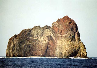
Report on Sumisujima (Japan) — 17 July-23 July 2024
Smithsonian Institution / US Geological Survey
Weekly Volcanic Activity Report, 17 July-23 July 2024
Managing Editor: Sally Sennert.
Please cite this report as:
Global Volcanism Program, 2024. Report on Sumisujima (Japan) (Sennert, S, ed.). Weekly Volcanic Activity Report, 17 July-23 July 2024. Smithsonian Institution and US Geological Survey.
Sumisujima
Japan
31.44°N, 140.051°E; summit elev. 136 m
All times are local (unless otherwise noted)
The Japan Coast Guard reported that an area of discolored water, brown to yellow-green in color, was visible about 300 m E of the E coast of Sumisujima on 18 July. The report noted that areas of discolored water had occasionally been seen in the vicinity of the island since 2017, though usually characterized as pale blue to white and smaller in size. Sailors were warned to exercise caution in the area.
Geological Summary. Sumisujima (also known as Smith Rocks) is a steep-sided basaltic pinnacle that forms part of the outer southern flank of a 8-9 km submarine caldera that truncates a 20-km-wide seamount. The caldera was formed between about 60,000 and 30,000 years ago. The Shirane dacitic central cone, 3 km wide and 800 m high, rises to within 8 m of the ocean surface in the eastern side of the caldera, whose 600-700 m walls and outer flanks expose basaltic, andesitic, and rhyolitic rocks. Two large submarine cones, Sumisu Knolls No. 1 and 2, lie west of the caldera. Submarine eruptions have been reported from a number of locations near Sumisujima, the last of which occurred in 1916. Water discoloration has frequently been observed since the 1970's. In October 1992 a 6-km-long zone of discolored water was seen extending from the shallow Shirane rock mass near the eastern rim of the caldera, which rises to within 7 m of the ocean surface and is the youngest feature of the volcanic complex.
Source: Japan Coast Guard

