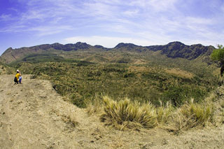
Report on Fentale (Ethiopia) — 15 January-21 January 2025
Smithsonian Institution / US Geological Survey
Weekly Volcanic Activity Report, 15 January-21 January 2025
Managing Editor: Sally Sennert.
Please cite this report as:
Global Volcanism Program, 2025. Report on Fentale (Ethiopia) (Sennert, S, ed.). Weekly Volcanic Activity Report, 15 January-21 January 2025. Smithsonian Institution and US Geological Survey.
Fentale
Ethiopia
8.985°N, 39.906°E; summit elev. 2007 m
All times are local (unless otherwise noted)
Satellite data analysis by the MIROVA team indicated that thermal anomalies over Fentale crater were visible during 13-14 January and progressively increased in size at least through 0020 on 21 January (local time). No cause of these anomalies has been identified. A visible satellite image showed a possible gas plume over the crater. A 14 January news article stated that the Fentale crater typically hosts a small lake and that billowing plumes rise above the summit. The article also noted that 10,000 people evacuated from Seganto and possibly a total of 54,000 had been evacuated from higher-risk areas. The earthquakes damaged schools, buildings, a factory, and roads.
Geological Summary. Fentale is a volcanic complex at the N end of the Main Ethiopian Rift that includes a main stratovolcano and caldera with various subsidiary features. Products are primarily rhyolitic obsidian lava flows with minor tuffs. Welded pantelleritic ash flows accompanied formation of a 2.5 x 4.5 km elliptical summit caldera, with steep-sided walls, that trends WNW-ESE, perpendicular to the rift. Post-caldera vents lie along the same orientation. Lava flows that appear to be more recent are present on the NE and SW flanks, and even darker trachytic and obsidian lava flows occur on the caldera floor. An eruption during the 13th century destroyed an Abyssinian town and church to the south. In 1820 CE basaltic lava flows effused from a 4-km-long fissure on the S flank; lava also flowed onto the caldera floor. During 2015 there was a seismic swarm and deformation NE of Fentale, caused by a dike intrusion that Temtime et al. (2020) determined was about 6 km long (striking N29°E) and 2 m wide, with a depth range of 5.4-8 km below the surface (volume change of about 33 x 106 m3).

