Report on Awu (Indonesia) — 29 January-4 February 2025
Smithsonian Institution / US Geological Survey
Weekly Volcanic Activity Report, 29 January-4 February 2025
Managing Editor: Sally Sennert.
Please cite this report as:
Global Volcanism Program, 2025. Report on Awu (Indonesia) (Sennert, S, ed.). Weekly Volcanic Activity Report, 29 January-4 February 2025. Smithsonian Institution and US Geological Survey.
Awu
Indonesia
3.689°N, 125.447°E; summit elev. 1318 m
All times are local (unless otherwise noted)
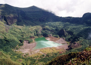
The Pusat Vulkanologi dan Mitigasi Bencana Geologi reported that seismicity at Awu had decreased. Swarms of both deep and shallow volcanic earthquakes continued to occur but at decreasing frequency; the last swarm occurred during 1807-1817 on 31 January and consisted of nine shallow volcanic earthquakes. Tiltmeter data from the Kolongan station indicated continuing inflation of the volcano. Emissions continued to rose 10-200 m above the summit and had not significantly changed since July 2024. At 0600 on 2 February the Alert Level was lowered to 2 (on a scale of 1-4) and the public was warned to stay 3 km away from the crater’s center.
Geological Summary. The massive Gunung Awu stratovolcano occupies the northern end of Great Sangihe Island, the largest of the Sangihe arc. Deep valleys that form passageways for lahars dissect the flanks of the volcano, which was constructed within a 4.5-km-wide caldera. Powerful explosive eruptions in 1711, 1812, 1856, 1892, and 1966 produced devastating pyroclastic flows and lahars that caused more than 8000 cumulative fatalities. Awu contained a summit crater lake that was 1 km wide and 172 m deep in 1922, but was largely ejected during the 1966 eruption.
Source: Pusat Vulkanologi dan Mitigasi Bencana Geologi (PVMBG, also known as CVGHM)