Report on Purace (Colombia) — 5 February-11 February 2025
Smithsonian Institution / US Geological Survey
Weekly Volcanic Activity Report, 5 February-11 February 2025
Managing Editor: Sally Sennert.
Please cite this report as:
Global Volcanism Program, 2025. Report on Purace (Colombia) (Sennert, S, ed.). Weekly Volcanic Activity Report, 5 February-11 February 2025. Smithsonian Institution and US Geological Survey.
Purace
Colombia
2.3095°N, 76.3948°W; summit elev. 4650 m
All times are local (unless otherwise noted)
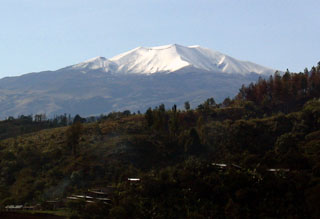
The Servicio Geologico Colombiano (SGC) reported that seismicity at Puracé was stable during 4-10 February with no significant variations in both the number and magnitude of events. Earthquakes indicating rock fracturing had a maximum magnitude of 1.1 and were mainly located under Puracé cone, and to a less extent under Piocollo cone, at depths of 1-3 km. Earthquakes indicating fluid movement were located at depths less than 1 km beneath Puracé cone. Sulfur dioxide emissions were above background levels and deformation was occurring between the cones of Puracé, Piocollo, and Curiquinga. Fumarolic plumes rose from the vents on the outer flank of Puracé cone, and from a system of vents and cracks that extended between the Curiquinga and Piocollo cones. The Alert Level remained at Yellow (the second lowest level on a four-color scale).
Geological Summary. Puracé is an active andesitic volcano with a 600-m-diameter summit crater at the NW end of the Los Coconucos Volcanic Chain. This volcanic complex includes nine composite and five monogenetic volcanoes, extending from the Puracé crater more than 6 km SE to the summit of Pan de Azúcar stratovolcano. The dacitic massif which the complex is built on extends about 13 km NW-SE and 10 km NE-SW. Frequent small to moderate explosive eruptions reported since 1816 CE have modified the morphology of the summit crater, with the largest eruptions in 1849, 1869, and 1885.