Report on Huaynaputina (Peru) — 12 February-18 February 2025
Smithsonian Institution / US Geological Survey
Weekly Volcanic Activity Report, 12 February-18 February 2025
Managing Editor: Sally Sennert.
Please cite this report as:
Global Volcanism Program, 2025. Report on Huaynaputina (Peru) (Sennert, S, ed.). Weekly Volcanic Activity Report, 12 February-18 February 2025. Smithsonian Institution and US Geological Survey.
Huaynaputina
Peru
16.6144°S, 70.8542°W; summit elev. 4679 m
All times are local (unless otherwise noted)
The Instituto Geofísico del Perú (IGP) reported that several lahars carrying blocks descended the S flank of Huaynaputina during 11-17 February and traveled towards the Tambo River. The lahars were recorded at 1309 on 11 February, at 1725 on 14 February, at 1712 on 15 February, at 1813 on 16 February, and at 1546 on 17 February. The public was warned to stay away from the drainage and to be cautious when traveling along the Quinistaquillas-Sijuaya highway.
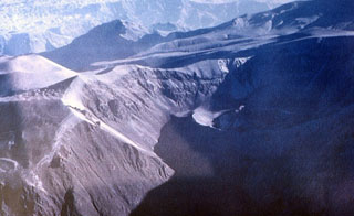
Geological Summary. Huaynaputina (whose name means "new volcano") was the source of the largest historical eruption of South America in 1600 CE. It has no prominent topographic expression and lies within a 2.5-km-wide collapse depression and further excavated by glaciers within a Tertiary to Pleistocene edifice. Three overlapping ash cones with craters up to 100 m deep were constructed during the 1600 CE eruption on the floor of the older crater, whose outer flanks are heavily mantled by ash deposits from the 1600 eruption. This powerful fissure-fed eruption may have produced nearly 30 km3 of dacitic tephra, including pyroclastic flows and surges that traveled 13 km to the E and SE. Lahars reached the Pacific Ocean, 120 km away. The eruption caused substantial damage to the major cities of Arequipa and Moquengua.