Report on Home Reef (Tonga) — 19 February-25 February 2025
Smithsonian Institution / US Geological Survey
Weekly Volcanic Activity Report, 19 February-25 February 2025
Managing Editor: Sally Sennert.
Please cite this report as:
Global Volcanism Program, 2025. Report on Home Reef (Tonga) (Sennert, S, ed.). Weekly Volcanic Activity Report, 19 February-25 February 2025. Smithsonian Institution and US Geological Survey.
Home Reef
Tonga
18.992°S, 174.775°W; summit elev. -10 m
All times are local (unless otherwise noted)
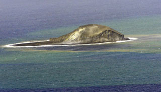
The Tonga Geological Services reported that increased thermal activity at Home Reef was identified in satellite images since 8 February with the latest signs of activity detected on 20 February. Satellite images from 8 February showed a larger crater that was about 78 m in diameter and about 50 m deep. The crater was had an estimated area of 4,350 square meters. Large blocks were scattered 65-75 m from the center of the crater, likely ejected during a recent eruptive event; the largest block was about 14 x 15 m. Small plumes rose from the vent that were ash-rich near the base and mostly comprised of gas and steam at higher levels. Satellite imagery on 20 February showed discolored water to the SW and a thermal anomaly over the vent. The Maritime Alert Level remained at Orange (the third level on a four-level scale), and mariners were advised to stay at least 2 nautical miles (3.7 km) away from the island. The Aviation Color Code remained at Yellow (the second level on a four-level scale), and the Alert Level for residents of Vava’u and Ha’apai remained at Green (the first level on a four-level scale).
Geological Summary. Home Reef, a submarine volcano midway between Metis Shoal and Late Island in the central Tonga islands, was first reported active in the mid-19th century, when an ephemeral island formed. An eruption in 1984 produced a 12-km-high eruption plume, large amounts of floating pumice, and an ephemeral 500 x 1,500 m island, with cliffs 30-50 m high that enclosed a water-filled crater. In 2006 an island-forming eruption produced widespread dacitic pumice rafts that drifted as far as Australia. Another island was built during a September-October 2022 eruption.