Report on Yakedake (Japan) — 26 February-4 March 2025
Smithsonian Institution / US Geological Survey
Weekly Volcanic Activity Report, 26 February-4 March 2025
Managing Editor: Sally Sennert.
Please cite this report as:
Global Volcanism Program, 2025. Report on Yakedake (Japan) (Sennert, S, ed.). Weekly Volcanic Activity Report, 26 February-4 March 2025. Smithsonian Institution and US Geological Survey.
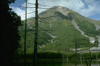
Yakedake
Japan
36.227°N, 137.587°E; summit elev. 2455 m
All times are local (unless otherwise noted)
The Japan Meteorological Agency (JMA) raised the Alert Level for Yakedake to 2 (on a scale of 1-5) at 0920 on 4 March, noting that the number of small volcanic earthquakes with epicenters near the summit began increasing around 1400 the day before. Additionally, inflation near the summit was detected in Global Navigation Satellite Systems (GNSS) data. JMA warned the public to be cautious within 1 km of the cater.
Geological Summary. Yakedake rises above the popular resort of Kamikochi in the Northern Japan Alps. The small dominantly andesitic stratovolcano, one of several Japanese volcanoes named Yakedake or Yakeyama ("Burning Peak" or "Burning Mountain"), was constructed astride a N-S-trending ridge between the older volcanoes of Warudaniyama and Shirataniyama. Akandanayama, about 4 km SSW, is a stratovolcano with lava domes that was active into the Holocene. A 300-m-wide crater is located at the summit, and explosion craters are found on the SE and N flanks. Frequent small-to-moderate phreatic eruptions have occurred during the 20th century. On 11 February 1995 a hydrothermal explosion in a geothermal area killed two people at a highway construction site.