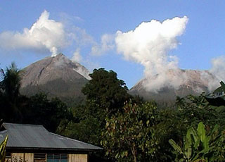
Report on Lewotobi (Indonesia) — 19 March-25 March 2025
Smithsonian Institution / US Geological Survey
Weekly Volcanic Activity Report, 19 March-25 March 2025
Managing Editor: Sally Sennert.
Please cite this report as:
Global Volcanism Program, 2025. Report on Lewotobi (Indonesia) (Sennert, S, ed.). Weekly Volcanic Activity Report, 19 March-25 March 2025. Smithsonian Institution and US Geological Survey.
Lewotobi
Indonesia
8.542°S, 122.775°E; summit elev. 1703 m
All times are local (unless otherwise noted)
The Pusat Vulkanologi dan Mitigasi Bencana Geologi (PVMBG) reported increased activity at Lewotobi Laki-laki during mid-March, culminating in a more intense phase on 20 March. Visual observations during 8-15 March indicated that the average height of emissions was increasing with white-to-gray ash plumes rising as high as 2.5 km above the summit. Seismic signals indicating emissions slightly increased, harmonic tremor fluctuated, the number of deep volcanic earthquakes and low-frequency earthquakes slightly decreased, though there was a slight increase in the number of deep volcanic earthquakes on 13 March. No shallow volcanic earthquakes were detected. Crater incandescence was visible on 13 March.
Activity significantly increased during 13-20 March. Daily gray ash plumes continued to rise as high as 2.5 km above the summit, though the average height of plumes had increased. Harmonic tremor continued to fluctuate and the number of low-frequency earthquakes slightly increased. A tornillo-type earthquake was detected on 16 March. The number of deep volcanic earthquakes increased significantly during 19-20 March totaling 205 compared to the average of 3-6 events per day. Shallow volcanic earthquakes began to be detected on 20 March indicating rising magma. Eruptive activity continued to intensify; in response PVMBG raised the Alert Level to 4 (on a scale of 1-4) at 2230 on 20 March and increased the exclusion zone to a radius of 7 km from the center of Laki-laki and 8 km in a semicircle clockwise from the SW to the NE. BNPB reported that residents were evacuated from several villages during 19-20 March including Pululera Village (8 km NW), Dulipali Village (6 km NNW), Padang Pasir (5 km NW), Nobo (5 km NE), Klatanlo (3 km NW), Hokeng Jaya (4 km NW), Boru (8 km WNW), and Nawakote.
Incandescence at the summit and possibly low on the NW flank was visible in a webcam image starting at 2245 on 20 March. An explosion at 2256 was recorded by several monitoring stations in Flores and heard in areas as far as Maumere City (63 km WSW) and Larantuka (35 km NE). The corresponding seismic signals lasted 11 minutes and nine seconds. A gray-to-black ash plume rose 8 km above the summit and drifted SW and W. According to the Darwin VAAC an ash plume was identified in a satellite at 2340 drifting W at an altitude of 16.1 km (53,000 ft) a.s.l., or 14.5 km above the summit. Dense gray ash plumes rose 2.5 km and 700 m above the summit and drifted W and N and NE at 0010 and 0122 on 21 March, respectively, according to PVMBG. BNPB reported that tephra fell in several surrounding areas. By 0300 the VAAC noted that the plume had detached from the summit and continued to drifted W. Lower-level ash emissions, at 6.1 km (20,000 ft) a.s.l., 4.4 km above the summit, drifted SE. Ash plumes continued to be identified in satellite images during 0600-0900; ash at 3-6.1 km (10,000-20,000 ft) a.s.l., 1.3-4.4 km above the summit, drifted SE and ash at 12.2 km (40,000 ft) a.s.l., 10.5 km above the summit, drifted SWW. The high-level ash plume at 16.1 km a.s.l. continued to drift W but was beginning to be obscured by weather clouds by 1000. Eruptive events were recorded at 1413 on 21 March, at 1916 on 22 March, at 0445 on 23 March, and at 0222 on 25 March, though weather clouds and/or darkness obscured views.
According to news reports and BNPB, two people suffered from burns but there were no fatalities during the 20-21 March eruption; around 4,000 people that had evacuated months earlier remained in temporary housing. News articles also noted that 16 international flights to and from the Ngurah Rai International Airport were cancelled, others were delayed, and some domestic flights were postponed.
Geological Summary. The Lewotobi edifice in eastern Flores Island is composed of the two adjacent Lewotobi Laki-laki and Lewotobi Perempuan stratovolcanoes (the "husband and wife"). Their summits are less than 2 km apart along a NW-SE line. The conical Laki-laki to the NW has been frequently active during the 19th and 20th centuries, while the taller and broader Perempuan has had observed eruptions in 1921 and 1935. Small lava domes have grown during the 20th century in both of the summit craters, which are open to the north. A prominent cone, Iliwokar, occurs on the E flank of Perampuan.
Sources: Pusat Vulkanologi dan Mitigasi Bencana Geologi (PVMBG, also known as CVGHM), Badan Nacional Penanggulangan Bencana (BNPB), Darwin Volcanic Ash Advisory Centre (VAAC), Antara News, Antara News, Antara News, Antara News

