Report on Rainier (United States) — 2 July-8 July 2025
Smithsonian Institution / US Geological Survey
Weekly Volcanic Activity Report, 2 July-8 July 2025
Managing Editor: Sally Sennert.
Please cite this report as:
Global Volcanism Program, 2025. Report on Rainier (United States) (Sennert, S, ed.). Weekly Volcanic Activity Report, 2 July-8 July 2025. Smithsonian Institution and US Geological Survey.
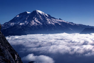
Rainier
United States
46.853°N, 121.76°W; summit elev. 4392 m
All times are local (unless otherwise noted)
The Cascades Volcano Observatory (CVO) reported that a small seismic swarm at Rainier began at 0129 on 8 July. By the 0926 the seismic network recorded hundreds of earthquakes at rates up to several per minute. The earthquakes were located at depths of 2-6 km below the summit; the largest earthquake, a M 1.7, was detected at 0452. No earthquakes were felt, no deformation was detected, and no anomalous signals were detected at infrasound monitoring stations. CVO noted that seismicity is typically about 9 earthquakes per month, plus swarms once or twice per year, but with much smaller numbers of events per swarm. The last large swarm at Rainier had over 1,000 earthquakes over three days in 2009 (120 located), had an earthquake with a maximum magnitude of 2.3. Past swarms have been attributed to circulation of fluids interacting with preexisting faults. The Volcano Alert Level remained at Normal (the lowest level on a four-level scale) and the Aviation Color Code remained at Green (the lowest color on a four-color scale).
Geological Summary. Mount Rainier is a heavily glaciated andesitic volcano in the Puget Sound region. Large Holocene mudflows from collapse have reached as far as the Puget Sound lowlands. The present summit was constructed within a large crater breached to the NE, formed by collapse during a major explosive eruption about 5,600 years ago that deposited the widespread Osceola Mudflow. Rainier has produced eruptions throughout the Holocene, including about a dozen during the past 2,600 years; the largest of these occurred about 2,200 years ago. The present summit cone is capped by two overlapping craters. Extensive hydrothermal alteration of the upper portion of the volcano has contributed to its structural weakness; an active thermal system has caused periodic melting on flank glaciers and produced an elaborate system of steam caves in the summit icecap. Reported uncertain 19th-century eruptions, including a possible but not confirmed phreatic eruption in 1894, have not left identifiable deposits.
Source: US Geological Survey Cascades Volcano Observatory (CVO)