Report on Erta Ale (Ethiopia) — 9 July-15 July 2025
Smithsonian Institution / US Geological Survey
Weekly Volcanic Activity Report, 9 July-15 July 2025
Managing Editor: Sally Sennert.
Please cite this report as:
Global Volcanism Program, 2025. Report on Erta Ale (Ethiopia) (Sennert, S, ed.). Weekly Volcanic Activity Report, 9 July-15 July 2025. Smithsonian Institution and US Geological Survey.
Erta Ale
Ethiopia
13.601°N, 40.666°E; summit elev. 585 m
All times are local (unless otherwise noted)
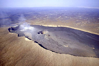
Eruptive activity at Erta Ale continued during July based on satellite data and field observations. Small thermal anomalies at both the N and S pit craters were visible in periodic satellite image views on 1, 6, 8, and 11 July. On 15 July a dense black plume rising from an unstated area was filmed by a local observer and was thought to have originated from a collapse of a portion of crust covering a lava lake. A post on social media showed pictures of the plumes and stated that the plumes sank to the ground and spread out over an area of 15 km. Plumes were visible on 16 July.
Geological Summary. The Erta Ale basaltic shield volcano in Ethiopia has a 50-km-wide edifice that rises more than 600 m from below sea level in the Danakil depression. The volcano includes a 0.7 x 1.6 km summit crater hosting steep-sided pit craters. Another larger 1.8 x 3.1 km wide depression elongated parallel to the trend of the Erta Ale range is located SE of the summit and is bounded by curvilinear fault scarps on the SE side. Basaltic lava flows from these fissures have poured into the caldera and locally overflowed its rim. The summit caldera usually also holds at least one long-term lava lake that has been active since at least 1967, and possibly since 1906. Recent fissure eruptions have occurred on the N flank.
Sources: Copernicus, Sputnik, Adal state