The Global Volcanism Program has no activity reports available for Itasy Volcanic Field.
The Global Volcanism Program has no Weekly Reports available for Itasy Volcanic Field.
The Global Volcanism Program has no Bulletin Reports available for Itasy Volcanic Field.
|
|
||||||||||||||||||||||||||
There is data available for 0 confirmed eruptive period.
[ 6050 BCE (in or before) ] Uncertain Eruption
| Episode 1 | Uncertain | ||||||||||||||
|---|---|---|---|---|---|---|---|---|---|---|---|---|---|---|
| 6050 BCE (in or before) - Unknown | Evidence from Isotopic: 14C (uncalibrated) | |||||||||||||
| A radiocarbon date of 8,000 BP from a peat layer was reported by Besairie (1973). | ||||||||||||||
|
List of 1 Events for Episode 1
|
||||||||||||||
[ 6555 BCE ± 90 years ] Uncertain Eruption
| Episode 1 | Uncertain | ||||
|---|---|---|---|---|
| 6555 BCE ± 90 years - Unknown | Evidence from Isotopic: 14C (uncalibrated) | |||
| Rasoazanamparany (2021) cited a radiocarbon date of 8,505 ± 90 years BP from Vogel (1970) of "peat associated with a phreatomagmatic maar deposit near Lake Itasy". This location and description could apply to other reported 14C dates from Besairie (1973) or Camus (1993, pers. comm.). | ||||
[ 8301 BCE ± 139 years ] Uncertain Eruption
| Episode 1 | Uncertain | |||||||||||||||||||
|---|---|---|---|---|---|---|---|---|---|---|---|---|---|---|---|---|---|---|---|
| 8301 BCE ± 139 years - Unknown | Evidence from Isotopic: 14C (calibrated) | ||||||||||||||||||
| Charcoal samples from a trachytic maar deposit 8.5 km N of the town of Soavinandriana are dated at 9,080 ± 100 years BP (Camus, 1993, pers. comm.), later calibrated to 8301 BCE ± 139. | |||||||||||||||||||
|
List of 2 Events for Episode 1
|
|||||||||||||||||||
This compilation of synonyms and subsidiary features may not be comprehensive. Features are organized into four major categories: Cones, Craters, Domes, and Thermal Features. Synonyms of features appear indented below the primary name. In some cases additional feature type, elevation, or location details are provided.
Cones |
||||
| Feature Name | Feature Type | Elevation | Latitude | Longitude |
| Ambohimalala | Cone | |||
| Ambohitritainerina | Cone | |||
| Ambohitrondry | Cone | |||
| Andranojavatra | Cone | |||
| Kassijie
Kassigie |
Cone | |||
| Kitombold | Cone | |||
| Matiankanina | Cone | |||
| Tsifajavona | Cone | |||
Craters |
||||
| Feature Name | Feature Type | Elevation | Latitude | Longitude |
| Andranoratsy | Crater | |||
| Andranotoraha | Crater | |||
Domes |
||||
| Feature Name | Feature Type | Elevation | Latitude | Longitude |
| Ambohibe | Dome | |||
| Ampary | Dome | |||
| Angavo | Dome | |||
| Ingilofotsy | Dome | |||
| Kitia | Dome | |||
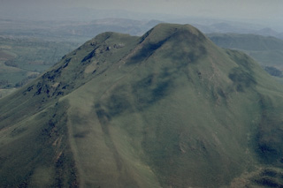 This vegetated lava dome is one of many at the Itasy volcanic field in central Madagascar. A steep-sided viscous lava flow descends to the left of the summit. Lateral levees at the margins of the flow form the distinct ridges at the lower left below a sharp bend in the lava flow.
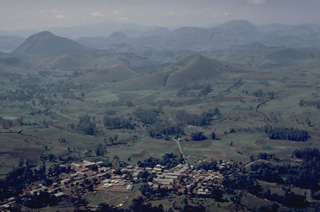 The Itasy volcanic field in central Madagascar contains a diverse assemblage of volcanic landforms, including scoria cones, lava domes, and maars. Activity began in the Pliocene and has continued into the Holocene. A trachytic maar was formed near Saovinandriana at the beginning of the Hololcene, and several other crater lakes are present. Thermal activity in the form of hot springs, and mild seismicity continues at Itasy.
 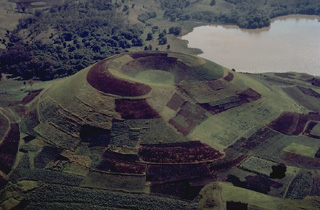 The Itasy volcanic field in central Madagascar contains numerous scoria cones, lava domes, and maar craters. The entire surface of this scoria cone, which has a shallow summit crater that is breached to the right, is mantled by geometric croplands of local farmers.
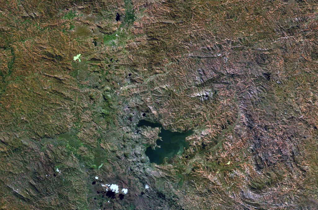
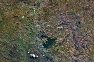 The Itasy volcanic field in central Madagascar lies W of Lake Itasy (lower center) and consists of a N-S-trending chain of scoria cones, lava domes, and maars. Several small dark-colored, lake-filled maars can be seen in the NASA Landsat image (N to the top), one of which lies just above the NW arm of Lake Itasy. Early eruptions producing trachytic lava domes and basanitic lava flows were followed by the effusion of trachytic lava flows and recent Vulcanian eruptions. Mild seismicity and hot spring activity continue at Itasy.
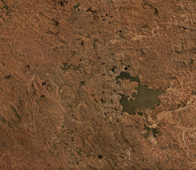 The Itasy Volcanic Field is a monogenetic field in central Madagascar around Lake Itasy near the center of this September 2019 Planet Labs satellite image mosaic (N at the top). The field contains scoria cones, lava domes, lava flows, and maars across an area of 1,600 km2. There have been 131 scoria cones identified throughout the field.
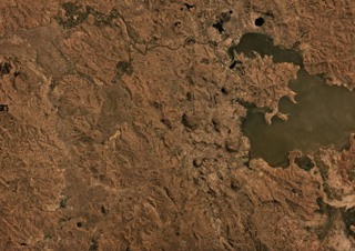 The Itasy Volcanic Field in central Madagascar covers an area of around 1,600 km2, some of which is seen here beside Lake Itasy in this September 2019 Planet Labs satellite image mosaic (N at the top). Several of the 131 identified scoria cones are in this area, as well as some lake-filled maar craters.
There are no samples for Itasy Volcanic Field in the Smithsonian's NMNH Department of Mineral Sciences Rock and Ore collection.
| Copernicus Browser | The Copernicus Browser replaced the Sentinel Hub Playground browser in 2023, to provide access to Earth observation archives from the Copernicus Data Space Ecosystem, the main distribution platform for data from the EU Copernicus missions. |
|
WOVOdat
Single Volcano View Temporal Evolution of Unrest Side by Side Volcanoes |
WOVOdat is a database of volcanic unrest; instrumentally and visually recorded changes in seismicity, ground deformation, gas emission, and other parameters from their normal baselines. It is sponsored by the World Organization of Volcano Observatories (WOVO) and presently hosted at the Earth Observatory of Singapore.
GVMID Data on Volcano Monitoring Infrastructure The Global Volcano Monitoring Infrastructure Database GVMID, is aimed at documenting and improving capabilities of volcano monitoring from the ground and space. GVMID should provide a snapshot and baseline view of the techniques and instrumentation that are in place at various volcanoes, which can be use by volcano observatories as reference to setup new monitoring system or improving networks at a specific volcano. These data will allow identification of what monitoring gaps exist, which can be then targeted by remote sensing infrastructure and future instrument deployments. |
| IRIS seismic stations/networks | Incorporated Research Institutions for Seismology (IRIS) Data Services map showing the location of seismic stations from all available networks (permanent or temporary) within a radius of 0.18° (about 20 km at mid-latitudes) from the given location of Itasy Volcanic Field. Users can customize a variety of filters and options in the left panel. Note that if there are no stations are known the map will default to show the entire world with a "No data matched request" error notice. |
| UNAVCO GPS/GNSS stations | Geodetic Data Services map from UNAVCO showing the location of GPS/GNSS stations from all available networks (permanent or temporary) within a radius of 20 km from the given location of Itasy Volcanic Field. Users can customize the data search based on station or network names, location, and time window. Requires Adobe Flash Player. |
| Large Eruptions of Itasy Volcanic Field | Information about large Quaternary eruptions (VEI >= 4) is cataloged in the Large Magnitude Explosive Volcanic Eruptions (LaMEVE) database of the Volcano Global Risk Identification and Analysis Project (VOGRIPA). |
| EarthChem | EarthChem develops and maintains databases, software, and services that support the preservation, discovery, access and analysis of geochemical data, and facilitate their integration with the broad array of other available earth science parameters. EarthChem is operated by a joint team of disciplinary scientists, data scientists, data managers and information technology developers who are part of the NSF-funded data facility Integrated Earth Data Applications (IEDA). IEDA is a collaborative effort of EarthChem and the Marine Geoscience Data System (MGDS). |

