The Global Volcanism Program has no activity reports available for Auckland Volcanic Field.
The Global Volcanism Program has no Weekly Reports available for Auckland Volcanic Field.
The Global Volcanism Program has no Bulletin Reports available for Auckland Volcanic Field.
|
|
||||||||||||||||||||||||||
There is data available for 2 confirmed eruptive periods.
1446 ± 5 years Confirmed Eruption (Explosive / Effusive)
| Episode 1 | Eruption (Explosive / Effusive) | Rangitoto, Rangitoto 2 | |||||||||||||
|---|---|---|---|---|---|---|---|---|---|---|---|---|---|---|
| 1446 ± 5 years - Unknown | Evidence from Isotopic: 14C (calibrated) | |||||||||||||
|
List of 1 Events for Episode 1 at Rangitoto, Rangitoto 2
|
||||||||||||||
1397 ± 7 years Confirmed Eruption (Explosive / Effusive)
| Episode 1 | Eruption (Explosive / Effusive) | Rangitoto, Rangitoto 1 | ||||||||||||||||||||||||||||
|---|---|---|---|---|---|---|---|---|---|---|---|---|---|---|---|---|---|---|---|---|---|---|---|---|---|---|---|---|---|
| 1397 ± 7 years - Unknown | Evidence from Isotopic: 14C (calibrated) | ||||||||||||||||||||||||||||
|
List of 4 Events for Episode 1 at Rangitoto, Rangitoto 1
|
|||||||||||||||||||||||||||||
This compilation of synonyms and subsidiary features may not be comprehensive. Features are organized into four major categories: Cones, Craters, Domes, and Thermal Features. Synonyms of features appear indented below the primary name. In some cases additional feature type, elevation, or location details are provided.
Cones |
||||
| Feature Name | Feature Type | Elevation | Latitude | Longitude |
| Albert Park | Cone | 40 m | 36° 51' 4.00" S | 174° 46' 12.00" E |
| Ash Hill | Tuff cone | 19 m | 36° 59' 58.00" S | 174° 51' 58.00" E |
| Boggust Park Crater | Tuff ring | 5 m | 36° 57' 19.00" S | 174° 48' 49.00" E |
| Duders Hill
Takamaiiwaho |
Former cone | |||
| Hampton Park | Cone - Crater | 35 m | 36° 57' 3.00" S | 174° 53' 44.00" E |
| Kohuora | Tuff cone | 30 m | 36° 58' 43.00" S | 174° 50' 34.00" E |
| Mangere Lagoon | Tuff ring | 19 m | 36° 57' 25.00" S | 174° 46' 39.00" E |
| Matanginui
Green Hill Green Mount |
Former cone | 78 m | 36° 56' 24.00" S | 174° 53' 54.00" E |
| Matukutureia
McLoughlin's Hill Matukurua |
Cone | 73 m | 37° 0' 49.00" S | 174° 50' 46.00" E |
| Maungakiekie
One Tree Hill |
Cone | 183 m | 36° 54' 0.00" S | 174° 59' 0.00" E |
| Maungarahiri
Little Rangitoto |
Cone | 75 m | 36° 52' 31.00" S | 174° 48' 35.00" E |
| Maungarei
Mount Wellington |
Cone | 135 m | 36° 53' 35.00" S | 174° 50' 48.00" E |
| Maungataketake
Ihumatao Ellett's Mount |
Former cone | 76 m | 36° 59' 41.00" S | 174° 44' 51.00" E |
| Maungauika
North Head |
Cone | 64 m | 36° 49' 40.00" S | 174° 48' 45.00" E |
| Maungawhau
Mount Eden |
Cone | 192 m | 36° 52' 41.00" S | 174° 45' 52.00" E |
| Motukorea
Brown's Island |
Cone | 59 m | 36° 49' 45.00" S | 174° 53' 46.00" E |
| Ohinerau
Mount Hobson |
Cone | 140 m | 36° 52' 40.00" S | 174° 47' 10.00" E |
| Ohuiarangi
Pigeon Mountain |
Cone | 55 m | 36° 53' 20.00" S | 174° 54' 11.00" E |
| Orakei Basin | Tuff ring | 0 m | 36° 52' 2.00" S | 174° 48' 49.00" E |
| Otahuhu
Mount Richmond |
Cone | 50 m | 36° 55' 57.00" S | 174° 50' 22.00" E |
| Otuataua | Cone | 64 m | 36° 59' 10.00" S | 174° 45' 15.00" E |
| Outhwaite Park | Cone | 80 m | 36° 51' 53.00" S | 174° 46' 13.00" E |
| Owairaka
Mount Albert Te Ahi-ka-a-Rakataura |
Cone | 152 m | 36° 53' 26.00" S | 174° 43' 12.00" E |
| Pukaki Lagoon | Tuff ring | 0 m | 36° 58' 59.00" S | 174° 48' 37.00" E |
| Pukeiti | Cone | 30 m | 36° 59' 2.00" S | 174° 45' 26.00" E |
| Pukekawa
Auckland Domain Grafton |
Tuff ring | 61 m | 36° 51' 34.00" S | 174° 46' 33.00" E |
| Pukewairiki | Tuff ring | 30 m | 36° 56' 39.00" S | 174° 51' 57.00" E |
| Pukewiwi
Mount Roskill Puketapapa |
Cone | 110 m | 36° 54' 46.00" S | 174° 44' 12.00" E |
| Rangitoto | Cone | 260 m | 36° 47' 11.00" S | 174° 51' 30.00" E |
| Rarotonga
Mount Smart |
Former cone | 87 m | 36° 55' 6.00" S | 174° 48' 45.00" E |
| Takararo
Cambria, Mount Sheep Hill Taka-a-raro |
Former cone | 30 m | 36° 49' 28.00" S | 174° 48' 7.00" E |
| Takarunga
Mount Victoria |
Cone | 87 m | 36° 49' 36.00" S | 174° 47' 56.00" E |
| Te Aponga-o-Tainui
McLennan Hills |
Former cone | 45 m | 36° 55' 45.00" S | 174° 50' 47.00" E |
| Te Kopuke
Mount Saint John Titikopuke |
Cone | 134 m | 36° 53' 1.00" S | 174° 46' 50.00" E |
| Te Manurewa o Tamapahore
Wiri Mountain |
Former cone | 80 m | 37° 0' 26.00" S | 174° 51' 30.00" E |
| Te Motu-a-Hiaroa
Puketutu |
Cone | 65 m | 36° 57' 55.00" S | 174° 44' 50.00" E |
| Te Pane-o-Mataaho
Mangere Mountain |
Cone | 106 m | 36° 56' 59.00" S | 174° 46' 59.00" E |
| Te Pou Hawaiki
Epsom Avenue Owhatihue |
Former cone | 120 m | 36° 52' 40.00" S | 174° 46' 5.00" E |
| Te Puke o Tara
Smales Mount Otara Hill |
Former cone | 89 m | 36° 56' 50.00" S | 174° 53' 54.00" E |
| Te Tapuwae a Mataoho
Robertson, Mount Robertson Hill Sturges Park |
Cone | 78 m | 36° 56' 55.00" S | 174° 50' 30.00" E |
| Te Tatua-a-Riukiuta
Three Kings Big King |
Cone | 133 m | 36° 54' 11.00" S | 174° 45' 17.00" E |
| Te Tauoma
Purchas Hill |
Former cone | 50 m | 36° 53' 14.00" S | 174° 50' 51.00" E |
| Te Taurere
Taylors Hill |
Cone | 56 m | 36° 51' 51.00" S | 174° 52' 12.00" E |
Craters |
||||
| Feature Name | Feature Type | Elevation | Latitude | Longitude |
| Cemetary Crater | Maar | 33 m | 36° 59' 23.00" S | 174° 50' 28.00" E |
| Crater Hill | Crater | 30 m | 36° 59' 13.00" S | 174° 49' 38.00" E |
| Onepoto | Maar | 1 m | 36° 48' 29.00" S | 174° 45' 0.00" E |
| Puhinui Craters | Maar | 22 m | 37° 0' 53.00" S | 174° 49' 59.00" E |
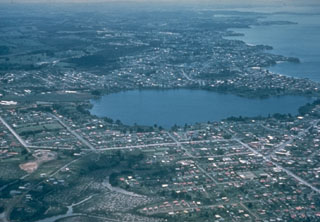
| Pupuke, Lake | Maar | -57 m | 36° 46' 48.00" S | 174° 45' 58.00" E |
| Styaks Swamp | Former crater | 20 m | 36° 56' 10.00" S | 174° 54' 1.00" E |
| Te Hopua a Rangi
Gloucester Park |
Maar | 0 m | 36° 55' 46.00" S | 174° 47' 5.00" E |
| Te Kopua Kai-a-Hiku
Panmure Basin |
Maar | 0 m | 36° 54' 18.00" S | 174° 50' 58.00" E |
| Te Kopua-o-Matakamokamo
Tank Farm |
Maar | 1 m | 36° 48' 6.00" S | 174° 45' 12.00" E |
| Waitomokia
Mount Gabriel |
Former crater | 20 m | 36° 58' 37.00" S | 174° 46' 13.00" E |
| Whakamuhu
Saint Heliers Glover Park |
Maar | 38 m | 36° 50' 50.00" S | 174° 52' 3.00" E |
 Auckland, New Zealand's largest city, is constructed over the 600 km2 Auckland Volcanic Field. The field contains more than 50 maars, tuff rings, and scoria cones that were formed during eruptions over the past 193,000 years. Only one volcano was formed during the Holocene. About 620-570 years ago, two phases of eruptive activity formed a low shield volcano capped by a scoria cone at Rangitoto.
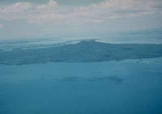 Rangitoto, a 6-km-wide island seen here from the NW, is the youngest feature of New Zealand's Auckland Volcanic Field. The volcano erupted at least twice, about 620 and 570 years ago, and is capped by a scoria cone containing a deep crater.
 Motukorea (also known as Brown's Island) in Waitemata Harbour, New Zealand, is composed of a remnant tuff ring (right side), scoria cones (center), and lava flows that form the flat peninsula in the foreground. It is one of more than 50 Pleistocene-to-Holocene centers in the Auckland Volcanic Field. The low-angle slopes of lava flows from Rangitoto are visible to the north in the background.
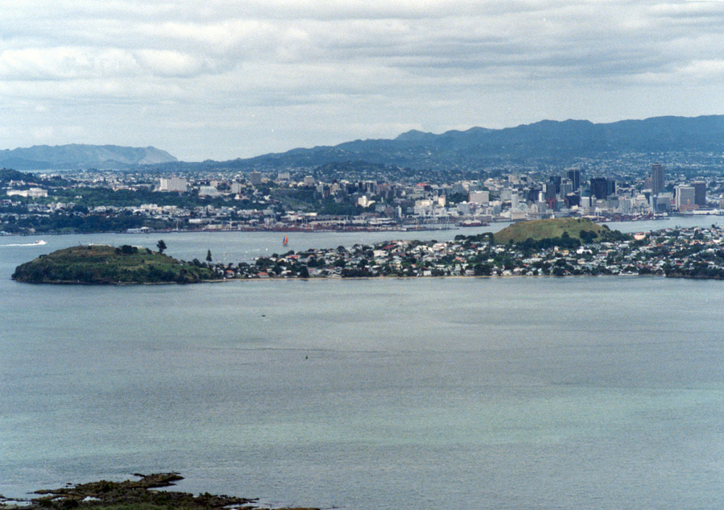
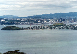 New Zealand's largest city, Auckland / Tamaki Makaurau, is built on the 600 km2 Auckland Volcanic Field. This view looking SW from the summit of Rangitoto volcano shows cones on a peninsula extending into Waitemata Harbor with the city center behind it. North Head (left) and Mount Victoria (right) on the peninsula are two of the more than 50 maars, tuff rings, and scoria cones that have formed in the past 193,000 years. Rangitoto is the only known Holocene volcano.
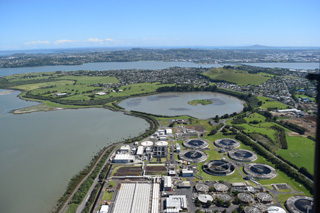 Mangere Lagoon is a tuff ring within the Auckland Volcanic Field, seen here from the south in 2018, with the Mangere Mountain scoria cone to the upper right. Rangitoto is in the distance.
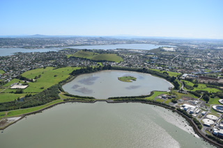 Mangere Lagoon is a tuff ring that formed during a phreatomagmatic eruption in the Auckland Volcanic field. The activity has been linked to the Mangere scoria cone behind it (immediately to the upper left). Rangitoto is to the upper left of this 2018 view from the SW.
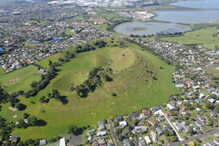 Mangere Mountain is a monogenetic cone within the Auckland Volcanic Field with spatter and scoria components, and several craters with extensive lava flows. The Mangere Lagoon tuff ring is to the upper right in this 2018 view from the NE.
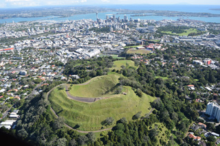 Maungawhau or Mount Eden is seen here in 2018 with the Auckland city center in the background. It is a scoria cone with a 50-m-deep crater and surrounding lava flows, and is one of around 50 vents within the Auckland Volcanic Field.
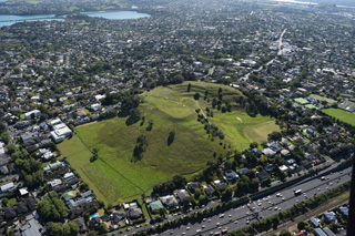 Ōhinerau or Mount Hobson is seen here from the west in 2018. The morphology has been extensively modified by pre-European Māori settlement that was later damaged by quarrying and reservoir construction.
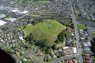 Mount Roskill or Pukewīwī / Puketāpapa is one of around 53 volcanic centers in the Auckland Volcanic field, seen here in 2018 from the south. The scoria cone was a source of lava flows around 100 ka.
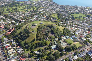 Mount Victoria or Takarunga is a scoria cone with a horseshoe-shaped crater in the Auckland Volcanic Field, seen here in 2018 from the north with the Waitematā Harbour at the top of the photo.
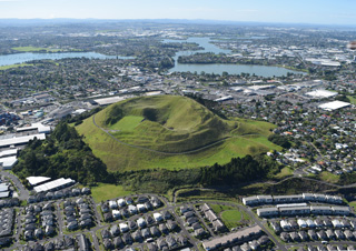 Mount Wellington or Maungarei is a scoria cone in the Auckland Volcanic Field with several summit craters that erupted around 10,000 years ago. This 2018 view from the NNW also shows the Panmure Basin or Te Kopua Kai-a-Hiku maar in the background.
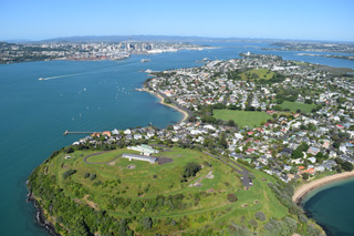 North Head or Maungauika is a scoria cone and tuff ring that formed in the Auckland Volcanic Field around 87 ka. This 2018 view from the east shows the Mount Victoria or Takarunga scoria cone to the upper right and the Auckland city center to the upper left.
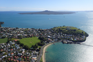 This 2018 photo from the SW shows the North Head or Maungauika scoria cone and Rangitoto in the background. Rangitoto is the largest volcanic feature in the Auckland Volcanic Field and unlike the other monogenetic centers, it formed over at least two eruptive episodes.
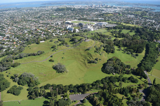 The One Tree Hill or Maungakiekie scoria cone has several summit craters and formed extensive lava flows during one of the larger eruptions of the Auckland Volcanic Field. This 2018 view is looking towards the SE with the Auckland city center in the background.
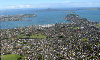 Pigeon Mountain or Ōhuiarangi is a scoria cone that has been modified by quarrying, seen in the triangular grassy area near the center of the photo. Rangitoto volcano is in the background of this 2018 photo showing part of the Auckland Volcanic Field.
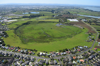 Pūkaki Lagoon or Te Pūkaki Tapu-o-Poutukeka is a maar crater within the Auckland Volcanic Field, seen here in 2018.
There are no samples for Auckland Volcanic Field in the Smithsonian's NMNH Department of Mineral Sciences Rock and Ore collection.
| Copernicus Browser | The Copernicus Browser replaced the Sentinel Hub Playground browser in 2023, to provide access to Earth observation archives from the Copernicus Data Space Ecosystem, the main distribution platform for data from the EU Copernicus missions. |
| MIROVA | Middle InfraRed Observation of Volcanic Activity (MIROVA) is a near real time volcanic hot-spot detection system based on the analysis of MODIS (Moderate Resolution Imaging Spectroradiometer) data. In particular, MIROVA uses the Middle InfraRed Radiation (MIR), measured over target volcanoes, in order to detect, locate and measure the heat radiation sourced from volcanic activity. |
| MODVOLC Thermal Alerts | Using infrared satellite Moderate Resolution Imaging Spectroradiometer (MODIS) data, scientists at the Hawai'i Institute of Geophysics and Planetology, University of Hawai'i, developed an automated system called MODVOLC to map thermal hot-spots in near real time. For each MODIS image, the algorithm automatically scans each 1 km pixel within it to check for high-temperature hot-spots. When one is found the date, time, location, and intensity are recorded. MODIS looks at every square km of the Earth every 48 hours, once during the day and once during the night, and the presence of two MODIS sensors in space allows at least four hot-spot observations every two days. Each day updated global maps are compiled to display the locations of all hot spots detected in the previous 24 hours. There is a drop-down list with volcano names which allow users to 'zoom-in' and examine the distribution of hot-spots at a variety of spatial scales. |
|
WOVOdat
Single Volcano View Temporal Evolution of Unrest Side by Side Volcanoes |
WOVOdat is a database of volcanic unrest; instrumentally and visually recorded changes in seismicity, ground deformation, gas emission, and other parameters from their normal baselines. It is sponsored by the World Organization of Volcano Observatories (WOVO) and presently hosted at the Earth Observatory of Singapore.
GVMID Data on Volcano Monitoring Infrastructure The Global Volcano Monitoring Infrastructure Database GVMID, is aimed at documenting and improving capabilities of volcano monitoring from the ground and space. GVMID should provide a snapshot and baseline view of the techniques and instrumentation that are in place at various volcanoes, which can be use by volcano observatories as reference to setup new monitoring system or improving networks at a specific volcano. These data will allow identification of what monitoring gaps exist, which can be then targeted by remote sensing infrastructure and future instrument deployments. |
| Volcanic Hazard Maps | The IAVCEI Commission on Volcanic Hazards and Risk has a Volcanic Hazard Maps database designed to serve as a resource for hazard mappers (or other interested parties) to explore how common issues in hazard map development have been addressed at different volcanoes, in different countries, for different hazards, and for different intended audiences. In addition to the comprehensive, searchable Volcanic Hazard Maps Database, this website contains information about diversity of volcanic hazard maps, illustrated using examples from the database. This site is for educational purposes related to volcanic hazard maps. Hazard maps found on this website should not be used for emergency purposes. For the most recent, official hazard map for a particular volcano, please seek out the proper institutional authorities on the matter. |
| IRIS seismic stations/networks | Incorporated Research Institutions for Seismology (IRIS) Data Services map showing the location of seismic stations from all available networks (permanent or temporary) within a radius of 0.18° (about 20 km at mid-latitudes) from the given location of Auckland Volcanic Field. Users can customize a variety of filters and options in the left panel. Note that if there are no stations are known the map will default to show the entire world with a "No data matched request" error notice. |
| UNAVCO GPS/GNSS stations | Geodetic Data Services map from UNAVCO showing the location of GPS/GNSS stations from all available networks (permanent or temporary) within a radius of 20 km from the given location of Auckland Volcanic Field. Users can customize the data search based on station or network names, location, and time window. Requires Adobe Flash Player. |
| DECADE Data | The DECADE portal, still in the developmental stage, serves as an example of the proposed interoperability between The Smithsonian Institution's Global Volcanism Program, the Mapping Gas Emissions (MaGa) Database, and the EarthChem Geochemical Portal. The Deep Earth Carbon Degassing (DECADE) initiative seeks to use new and established technologies to determine accurate global fluxes of volcanic CO2 to the atmosphere, but installing CO2 monitoring networks on 20 of the world's 150 most actively degassing volcanoes. The group uses related laboratory-based studies (direct gas sampling and analysis, melt inclusions) to provide new data for direct degassing of deep earth carbon to the atmosphere. |
| Large Eruptions of Auckland Volcanic Field | Information about large Quaternary eruptions (VEI >= 4) is cataloged in the Large Magnitude Explosive Volcanic Eruptions (LaMEVE) database of the Volcano Global Risk Identification and Analysis Project (VOGRIPA). |
| EarthChem | EarthChem develops and maintains databases, software, and services that support the preservation, discovery, access and analysis of geochemical data, and facilitate their integration with the broad array of other available earth science parameters. EarthChem is operated by a joint team of disciplinary scientists, data scientists, data managers and information technology developers who are part of the NSF-funded data facility Integrated Earth Data Applications (IEDA). IEDA is a collaborative effort of EarthChem and the Marine Geoscience Data System (MGDS). |

