
A submarine eruption in early August from an unnamed seamount about 50 km NW of Vava’u in Tonga created extensive areas of pumice rafts. Sailing crews encountered the pumice starting on 9 August about 40 km NNW of Late Island. Rachel Mackie described a pronounced odor of sulfur, and eventually being surrounded as far as she could see, with the surface pumice layer being 30 cm deep and containing pieces up to 80 cm in diameter. Sentinel-2 satellite imagery from 11 August showed the raft, averaging about 2.5 km across but strung out for 35 km NE-SW, located 70 km WNW of Late Island; another band of scattered rafts extended directly back from the main mass towards Late for 50 km. The raft continued drifting, and was at least another 60 km SW from its previous location as of 16 August. Eruptive activity at this location was previously reported in September-October 2001.
Sources: Martin Jutzeler, Sentinel Hub, Rachel Mackie
Additional details and pumice raft drift maps from the August 2019 submarine eruption
In the northern Tonga region, approximately 80 km NW of Vava’u, large areas of floating pumice, termed rafts, were observed starting as early as 7 August 2019. The area of these andesitic pumice rafts was initially 195 km2 with the layers measuring 15-30 cm thick and were produced 200 m below sea level (Jutzeler et al. 2020). The previous report (BGVN 44:11) described the morphology of the clasts and the rafts, and their general westward path from 9 August to 9 October 2019, with the first sighting occurring on 9 August NW of Vava’u in Tonga. This report updates details regarding the submarine pumice raft eruption in early August 2019 using new observations and data from Brandl et al. (2019) and Jutzeler et al. (2020).
The NoToVE-2004 (Northern Tonga Vents Expedition) research cruise on the RV Southern Surveyor (SS11/2004) from the Australian CSIRO Marine National Facility traveled to the northern Tonga Arc and discovered several submarine basalt-to-rhyolite volcanic centers (Arculus, 2004). One of these volcanic centers 50 km NW of Vava’u was the unnamed seamount (volcano number 243091) that had erupted in 2001 and again in 2019, unofficially designated “Volcano F” for reference purposes by Arculus (2004) and also used by Brandl et al. (2019). It is a volcanic complex that rises more than 1 km from the seafloor with a central 6 x 8.7 km caldera and a volcanic apron measuring over 50 km in diameter (figures 19 and 20). Arculus (2004) described some of the dredged material as “fresh, black, plagioclase-bearing lava with well-formed, glassy crusts up to 2cm thick” from cones by the eastern wall of the caldera; a number of apparent flows, lava or debris, were observed draping over the northern wall of the caldera.
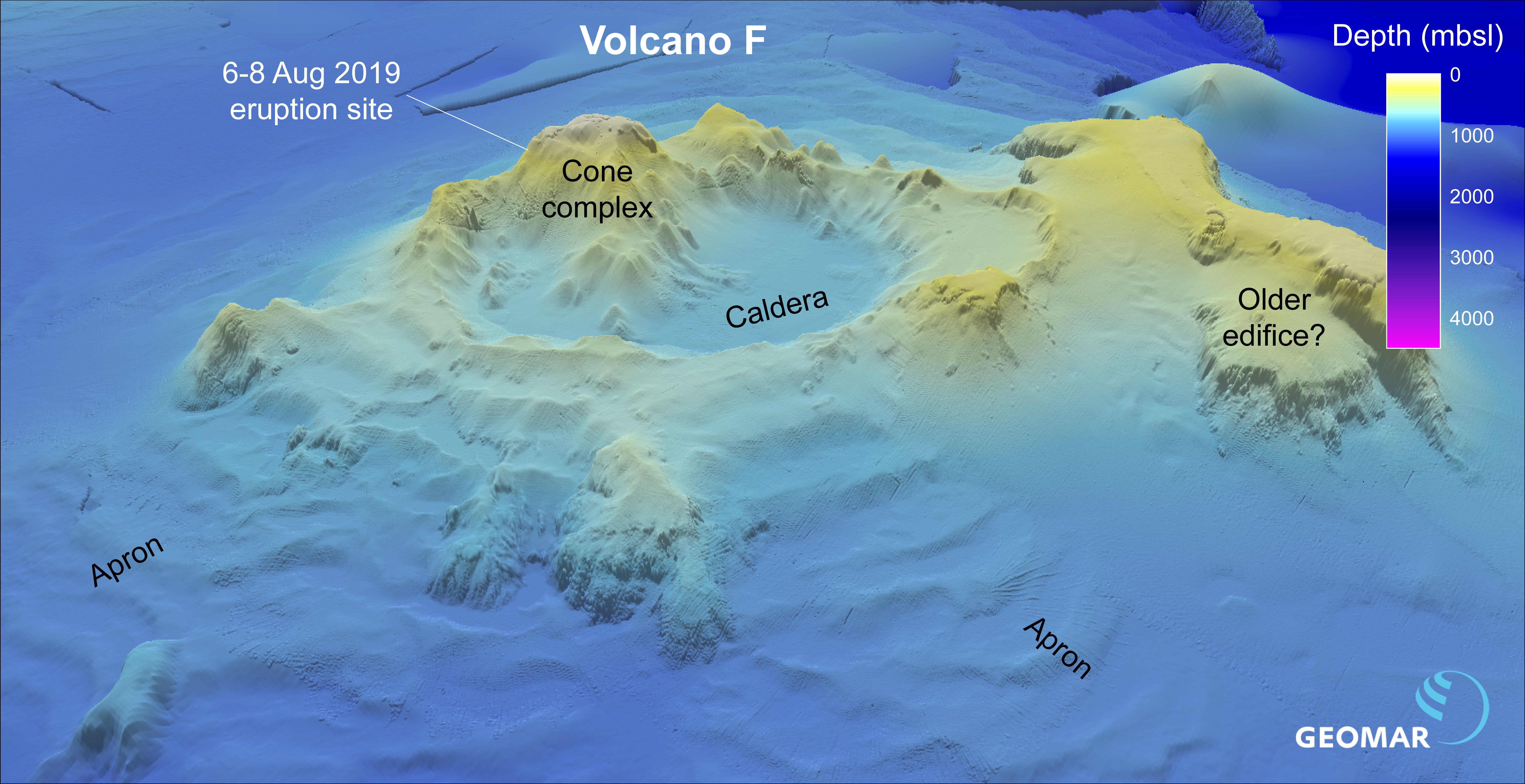 |
Figure 19. Visualization of the unnamed submarine Tongan volcano (marked “Volcano F”) using bathymetric data to show the site of the 6-8 August 2020 eruption and the rest of the cone complex. Courtesy of Philipp Brandl via GEOMAR. |
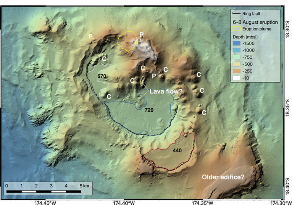 |
Figure 20. Map of the unnamed submarine Tongan volcano using satellite imagery, bathymetric data, with shading from the NW. The yellow circle indicates the location of the August 2019 activity. Young volcanic cones are marked “C” and those with pit craters at the top are marked with “P.” Courtesy of Brandl et al. (2019). |
The International Seismological Centre (ISC) Preliminary Bulletin listed a particularly strong (5.7 Mw) earthquake at 2201 local time on 5 August, 15 km SSW of the volcano at a depth of 10 km (Brandl et al. 2019). This event was followed by six slightly lower magnitude earthquakes over the next two days.
Sentinel-2 satellite imagery showed two concentric rings originating from a point source (18.307°S 174.395°W) on 6 August (figure 21), which could be interpreted as small weak submarine plumes or possibly a series of small volcanic cones, according to Brandl et al. (2019). The larger ring is about 1.2 km in diameter and the smaller one measures 250 m. By 8 August volcanic activity had decreased, but the pumice rafts that were produced remained visible through at least early October (BGVN 44:11). Brandl et al. (2019) states that, due to the lack of continued observed activity rising from this location, the eruption was likely a 2-day-long event during 6-8 August.
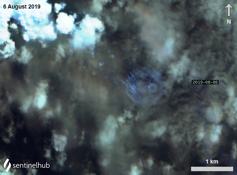 |
Figure 21. Sentinel-2 satellite image of possible gas/vapor emissions (streaks) on 6 August 2019 drifting NW, which is the interpreted site for the unnamed Tongan seamount. The larger ring is about 1.2 km in diameter and the smaller one measures 250 m. Image using False Color (urban) rendering (bands 12, 11, 4); courtesy of Sentinel Hub Playground. |
The pumice was first observed on 9 August occurred up to 56 km from the point of origin, according to Jutzeler et al. (2020). By calculating the velocity (14 km/day) of the raft using three satellites, Jutzeler et al. (2020) determined the pumice was erupted immediately after the satellite image of the submarine plumes on 6 August (UTC time). Minor activity at the vent may have continued on 8 and 11 August (UTC time) with pale blue-green water discoloration (figure 22) and a small (less than 1 km2) diffuse pumice raft 2-5 km from the vent.
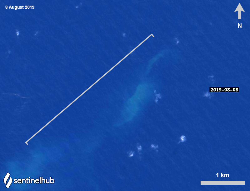 |
Figure 22. Sentinel-2 satellite image of the last visible activity occurring W of the unnamed submarine Tongan volcano on 8 August 2019, represented by slightly discolored blue-green water. Image using Natural Color rendering (bands 4, 3, 2) and enhanced with color correction; courtesy of Sentinel Hub Playground. |
Continuous observations using various satellite data and observations aboard the catamaran ROAM tracked the movement and extent of the pumice raft that was produced during the submarine eruption in early August (figure 23). The first visible pumice raft was observed on 8 August 2019, covering more than 136.7 km2 between the volcanic islands of Fonualei and Late and drifting W for 60 km until 9 August (Brandl et al. 2019; Jutzeler 2020). The next day, the raft increased to 167.2-195 km2 while drifting SW for 74 km until 14 August. Over the next three days (10-12 August) the size of the raft briefly decreased in size to less than 100 km2 before increasing again to 157.4 km2 on 14 August; at least nine individual rafts were mapped and identified on satellite imagery (Brandl et al. 2019). On 15 August sailing vessels observed a large pumice raft about 75 km W of Late Island (see details in BGVN 44:11), which was the same one as seen in satellite imagery on 8 August.
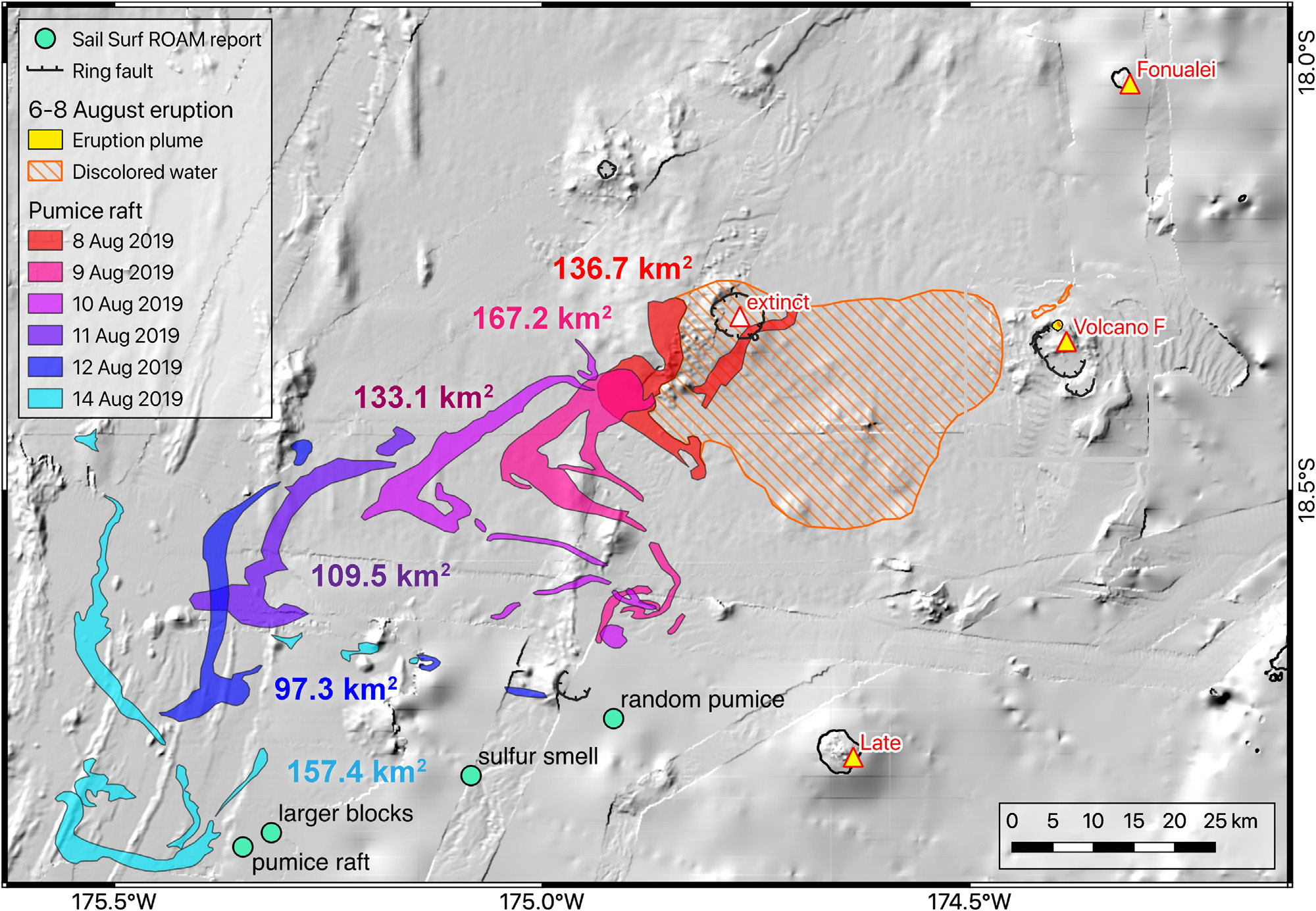 |
Figure 23. Map of the extent of discolored water and the pumice raft from the unnamed submarine Tongan volcano between 8 and 14 August 2019 using imagery from NASA’s MODIS, ESA’s Sentinel-2 satellite, and observations from aboard the catamaran ROAM (BGVN 44:11). Back-tracing the path of the pumice raft points to a source location at the unnamed submarine Tongan volcano. Courtesy of Brandl et al. (2019). |
By 17 August high-resolution satellite images showed an area of large and small rafts measuring 222 km2 and were found within a field of smaller rafts for a total extent of 1,350 km2, which drifted 73 km NNW through 22 August before moving counterclockwise for three days (figure f; Jutzeler et al., 2020). Small pumice ribbons encountered the Oneata Lagoon on 30 August, the first island that the raft came into contact (Jutzeler et al. 2020). By 2 September, the main raft intersected with Lakeba Island (460 km from the source) (figure 24), breaking into smaller ribbons that started to drift W on 8 September. On 19 September the small rafts (less than 100 m x less than 2 km) entered the strait between Viti Levu and Vanua Levu, the two main islands of Fiji, while most of the others were stranded 60 km W in the Yasawa Islands for more than two months (Jutzeler et al., 2020).
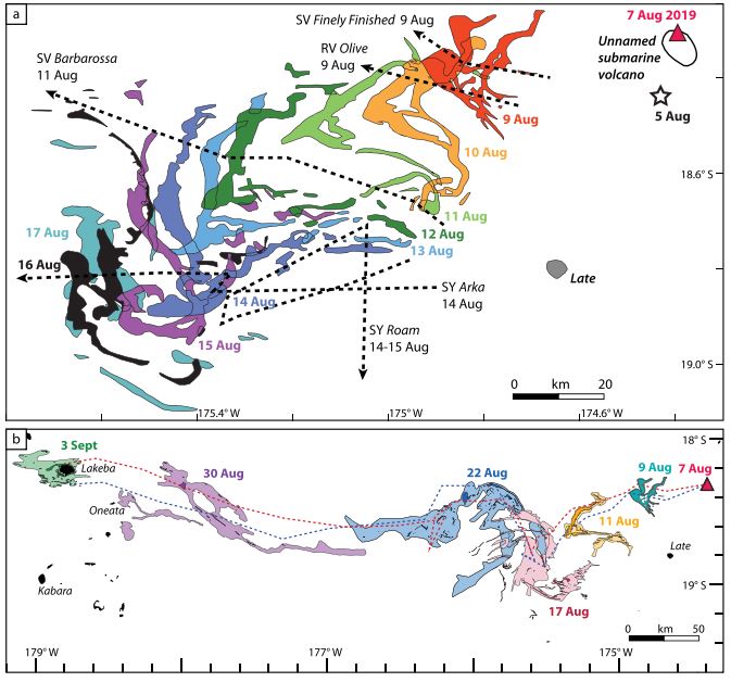 |
Figure 24. Time-series map of the raft dispersal from the unnamed submarine Tongan volcano using multiple satellite images. A) Map showing the first days of the raft dispersal starting on 7 August 2019 and drifting SW from the vent (marked with a red triangle). Precursory seismicity that began on 5 August is marked with a white star. By 15-17 August the raft was entrained in an ocean loop or eddy. The dashed lines represent the path of the sailing vessels. B) Map of the raft dispersal using high-resolution Sentinel-2 and -3 imagery. Two dispersal trails (red and blue dashed lines) show the daily dispersal of two parts of the raft that were separated on 17 August 2019. Courtesy of Jutzeler et al. (2020). |
References: Arculus R J, SS2004/11 shipboard scientists, 2004. SS11/2004 Voyage Summary: NoToVE-2004 (Northern Tonga Vents Expedition): submarine hydrothermal plume activity and petrology of the northern Tofua Arc, Tonga. https://www.cmar.csiro.au/data/trawler/survey_details.cfm?survey=SS200411
Brandl P A, Schmid F, Augustin N, Grevemeyer I, Arculus R J, Devey C W, Petersen S, Stewart M , Kopp K, Hannington M D, 2019. The 6-8 Aug 2019 eruption of ‘Volcano F’ in the Tofua Arc, Tonga. Journal of Volcanology and Geothermal Research: https://doi.org/10.1016/j.jvolgeores.2019.106695
Jutzeler M, Marsh R, van Sebille E, Mittal T, Carey R, Fauria K, Manga M, McPhie J, 2020. Ongoing Dispersal of the 7 August 2019 Pumice Raft From the Tonga Arc in the Southwestern Pacific Ocean. AGU Geophysical Research Letters: https://doi.orh/10.1029/2019GL086768.
Information Contacts: Jan Steffen, Communication and Media, GEOMAR Helmholtz Centre for Ocean Research, Kiel, Germany; Sentinel Hub Playground (URL: https://www.sentinel-hub.com/explore/sentinel-playground).
2019: August
A submarine eruption in early August from an unnamed seamount about 50 km NW of Vava’u in Tonga created extensive areas of pumice rafts. Sailing crews encountered the pumice starting on 9 August about 40 km NNW of Late Island. Rachel Mackie described a pronounced odor of sulfur, and eventually being surrounded as far as she could see, with the surface pumice layer being 30 cm deep and containing pieces up to 80 cm in diameter. Sentinel-2 satellite imagery from 11 August showed the raft, averaging about 2.5 km across but strung out for 35 km NE-SW, located 70 km WNW of Late Island; another band of scattered rafts extended directly back from the main mass towards Late for 50 km. The raft continued drifting, and was at least another 60 km SW from its previous location as of 16 August. Eruptive activity at this location was previously reported in September-October 2001.
Sources: Martin Jutzeler; Sentinel Hub; Rachel Mackie
Reports are organized chronologically and indexed below by Month/Year (Publication Volume:Number), and include a one-line summary. Click on the index link or scroll down to read the reports.
Possible source for September T-waves and November pumice rafts
[The following originally appeared as part of a report on Fonualei. Later investigations showed that the seismicity and pumice rafts in question most likely came from an unnamed submarine volcano in the Tonga Islands.]
Seismicity. During 28-29 September 2001 numerous short T-waves were registered by the French Polynesian Seismic Network. The preliminary location of the seismicity was determined to be near the Tonga archipelago at 18.18°S (well constrained) and 174°W (not as well constrained). This spot lies ~40 km W of Fonualei.
The swarm began at 0550 on 28 September and ended at 1113 on 29 September (figure 1). The strongest T-wave was registered at 1229 on 28 September at the PAE seismic station in Tahiti (figure 2). The hydro-acoustic activity was interpreted to be volcanic and explosive and not related to seismicity at the Tonga trench. According to the Laboratoire de Géophysique, the source could be near Fonualei.
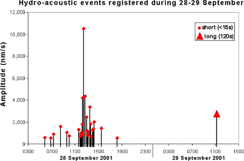 |
Figure 1. A plot showing the overall character of the T-wave swarm inferred to have come from Fonualei during 28-29 September 2001. Basically, the cluster of T waves seen in the main part of the swarm (28 September) consisted of signals with short (15-second) periods. Some of these signals were comparatively strong. T waves seen later in the swarm (1100 on 29 September) had long (120-second) period. Courtesy of Laboratoire de Géophysique. |
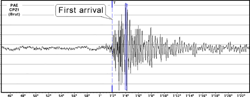 |
Figure 2. Seismic trace of the strongest of the T-wave signals attributed to Fonualei during the swarm of 28-29 September 2001. The trace was recorded at 1229 on 28 September at the PAE seismic station in Tahiti (the trace was labeled "PAE CPZ1 (Brut)"). Courtesy of Laboratoire de Géophysique. |
Pumice rafts. Roman Leslie, a Ph.D. student at the University of Tasmania visited Fiji (hundreds of kilometers W of Tonga) during 9-25 November 2001. There he observed large (100-m diameter) pumice rafts of gray, aphyric pumice clasts ranging from sand-sized to ~20 cm in diameter. Local residents hadn't seen such large rafts before, but had noticed occasional clasts in recent history.
Leslie initially observed the pumice rafts while on Kadavu island of the Lomaiviti Group while diving on the southern Astrolabe Reef from the 10th-15th. He again saw pumice rafts in the Koro Sea during a flight from Suva to Koro on the 16th. Next, he found them on the coral coast (southern Viti Levu) on the 24th, where samples were collected ~5 km E of Sigatoka.
There he collected pumice samples from the beach at or near the high-tide mark, where they formed discontinuous wave-derived lag deposits of limited thickness, with ~5 m lateral extent. Beach pumice deposits and floating rafts (up to ~150 m in length) were poorly sorted and consisted of brown-grey clasts ranging from ~2 to 100 mm in diameter. Clasts were sub-angular to sub-rounded and appeared to contain small phenocrysts of clinopyroxene and plagioclase. Judging from the approximate color index and mineralogy it seemed that the samples were broadly andesitic.
Whether or not the pumice rafts seen in Fiji during November are related to the activity that registered as T-waves from Tonga during late September is uncertain. The rafts and T-waves may be entirely unrelated in terms of source location, or they may result from a common eruption, perhaps at Fonualei.
Information Contacts: Olivier Hyvernaud; Laboratoire de Géophysique; PO Box 640 Papeete; Tahiti; French Polynesia; Roman Leslie, Centre for Ore Deposit Research, University of Tasmania, GPO Box 252-79, Hobart, TAS 7001, Australia (URL: http://www.utas.edu.au/codes/).
Submarine center identified S of Fonualei may be the source of T-waves and pumice
The following was largely condensed from a report by Paul Taylor submitted to the Tongan government (Taylor, 2002). Our previous report on the topic appeared under the heading "Fonualei" (BGVN 26:11). The bulk of that report described T-wave signals on 28-29 September 2001 traced to near Fonualei and fresh pumice found along beaches in Fiji (hundreds of kilometers W of Tonga) during 9-25 November 2001. The T-wave signals and pumice sightings both relate to the activity discussed here.
During September through early November 2001, submarine volcanic activity was observed ~33 km S of Fonualei (figure 3). This same spot lies ~30 km NW of the Vava'u Group of the Tongan islands. This volcanic center lacked prior historical activity, although Taylor and Ewart (1997) indicated that a number of submarine structures were present between Late and Fonualei islands.
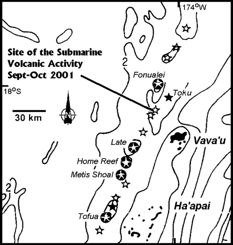 |
Figure 3. Map of the Vava'u region, with the Tonga Platform (to the E) and the active volcano belt (to the W), showing the site of the recent (September-October 2001) submarine volcanic activity. The symbols indicate active centers (white stars within black circles), i.e. those with recorded eruptions; inactive centers (solid black stars ), i.e. those with no recorded activity, and probable submarine centers (open stars). Bathymetric contours are in kilometers below sea level. Courtesy of Paul Taylor. |
Form, structure, and depth. Although no details are available concerning the form and structure of this eruptive site, it is likely to be the summit of a submarine stratovolcano that rises from a NNE-SSW trending topographic high. A shoal has not been reported at the site during historical times. No surveys of this area have been conducted; however, its bathymetry suggests that several submarine structures rise from a depth of about 1 km to probably within 200-300 m of the surface. No shoal or island was observed when the site was visited by the Tonga Defense Services during early and mid-October 2001.
Volcanic activity. The activity appears to have been submarine and explosive in character. Known reports relating to this eruption are given in table 1. A plot of the seismic activity from stations in the Cook Islands and French Polynesia during 28-29 September 2001 were provided in Figure 1 of BGVN 26:11.
Table 1. A summary of observations relating to an unnamed submarine volcano (NW of Vava'u, Tonga). Latitudes and longitudes appear in degrees and decimal degrees; the original used degrees-minutes-seconds. Other significant revisions and substitutions to the original appear as text in brackets. Courtesy of Paul Taylor.
| Date | Activity |
| 27-28 Sep 2001 | T-phase seismic waves from a probable volcanic source recorded in French Polynesia. Approximate coordinates of 18.39°S; 174.6°W, are located near the Vava'u Group. |
| 27 Sep 2001 | 1800 - Reports of submarine activity were received from near Vava'u. A local fisherman experienced "an abnormal disturbance from the deep ocean." Shortly after an ash-rich eruption column rose from the sea at 18.325°S, 174.365°W. |
| 28 Sep 2001 | 1300 - An "island" was reported to have formed during the explosive activity with an ash-rich eruption column still being produced. The "island" was estimated to be about 2 miles [~ 3 km] long. The sea was "highly disturbed and silky" at this time. |
| 01 Oct 2001 | 0930 - Royal Tongan Airlines flights 801 and 802 reported that activity above the surface had ceased. A huge underwater bank, about 1.5 miles [2.4 km] across, was observed at 18.358°S, 174.346°W, [3.8 km SW] of the initial location. The water was reported as "boiling bubbles of seawater oozing out from the area to the sea surface". |
| 03 Oct 2001 | A Tonga Defense Services patrol boat visited the area, but due to heavy seas observations were restricted. The surface of the sea in the region was discolored a "dark whitish color". The discolored area was estimated to be 3 miles [~ 5 km] long (N-S direction) and 1.5-2 miles[2.4-3 km] wide. Near the reported location, the sea appeared to contain a mixture of whitish and yellow-brownish substances although no pumice was observed floating on the surface. A local Notice to Mariners (NTM 15/01) was issued, warning shipping to stay away from the area. |
| 09 Oct 2001 | 1600 - A Tonga Defense Services aircraft flew over the site and reported that an area of discolored water was present. No eruption column or pumice was observed and the island reported earlier was not present. |
| 26 Oct 2001 | A Tonga Defense Services patrol boat visited the site and observed an area of discolored water 300 m long (NE-SW direction) centered on a position of 18.303°S, 174.377°W, [a spot 2.7 km NE of the initial position]. The discoloration was light-brownish in the center and light greenish toward the outside. The charted depth of the shoal at this location was 298 meters. No depth was recorded by the boat's echo sounder and no attempt was made to take a sounding over the discolored water. |
| early Nov 2001 | Pumice strandings were reported along the coast of Kadavu and on the S coast of Viti Levu, Fiji. Rafts reported to be over 100 m in diameter with pumice fragments ranging in size from under 1 cm to ~20 cm. |
Comments. As noted above, the charted depth prior to the eruption was ~200-300 m and the syn-eruptive depth was not determined. Further, Taylor learned that post-eruptive depths had not been taken at the site. He goes on to state, "The initial activity was the result of submarine explosions, producing what was reported as 'an island' and an eruption column." In his report, Taylor concluded that the island was essentially a floating pumice raft and ". . . was more likely the effect of gases and pyroclastic material produced by the explosions breaking the surface, which appeared land-like. An eruption column of predominantly volcanic gas, steam, and pyroclastic material was then ejected above the surface."
Taylor (2002) goes on to discuss relevant volcanic hazards. Regarding approaching the volcano, he recommended that access be prohibited within 2 km, access restricted within the interval 2 to 4 km, and extreme care be taken when approaching or within the interval 4 to 5 km.
References. Taylor, P.W., 2002, Volcanic hazards assessment following the September-October 2001 eruption of a previously unrecognized submarine volcano W of Vava'u, kingdom of Tonga: Australian Volcanological Investigations, AVI Occasional Report No. 02/01
Taylor, P.W., 1999, A volcanic hazards assessment following the January 1999 eruption of Submarine Volcano III Tofua Volcanic Arc, Kingdom of Tonga: Australian Volcanological Investigations, AVI Occasional Report No. 99/01.
Taylor, P.W., and Ewart, A., 1997, The Tofua Volcanic Arc, Tonga, SW Pacific: A review of historic volcanic activity: Australian Volcanological Investigations, AVI Occasional Report No. 97/01.
Information Contacts: Paul Taylor, Australian Volcanological Investigations, PO Box 291, Pymble NSW 2073, Australia; Olivier Hyvernaud, Laboratoire de Geophysique, Papeete Tahiti, French Polynesia; Dan Shackelford, 3124 E. Yorba Linda Blvd., Apt. H-33, Fullerton, CA 92831-2324, USA.
Pumice rafts from September-October 2001 eruption reach eastern Australia
A felsic shallow marine explosive eruption from a previously unknown volcano along the Tofua volcanic arc (Tonga) in September-October 2001 (BGVN 26:11 and 27:01) produced floating pumice rafts in Fiji in November 2001, approximately one month after it occurred. These sea-rafted pumice are the only recorded output of this subaqueous eruption at a remote location where direct observations are limited.
A new influx of sea-rafted pumice reached the eastern coast of Australia in October 2002 (figure 4), approximately one year after the eruption was first indicated by seismic activity and pumice stranding in Fiji. Pumice was stranded along at least two-thirds (>2,000 km) of the coastline of eastern Australia, extending from N of Townsville to Sydney. Typical amounts of pumice initially stranded on beaches were 500-4,000 individual clasts per m2; a minimum volume estimate of pumice deposited along the eastern Australian coastline is 1.25 x 10⁵ m3. Most stranded pumice clasts are 1-5 cm diameter, although some outsized clasts are up to 10 cm. Many clasts were fouled by a variety of organisms, and dark algal coverings were common to all clasts that concealed the primary character of the pumice (figure 5). This is in contrast to pumice stranded on beaches in Fiji ~ 1 month after the eruption, which were clean of fouling organisms. Fouling organisms include algae, Bryozoa, serpulid worms, corals and, oysters with goose barnacles particularly abundant.
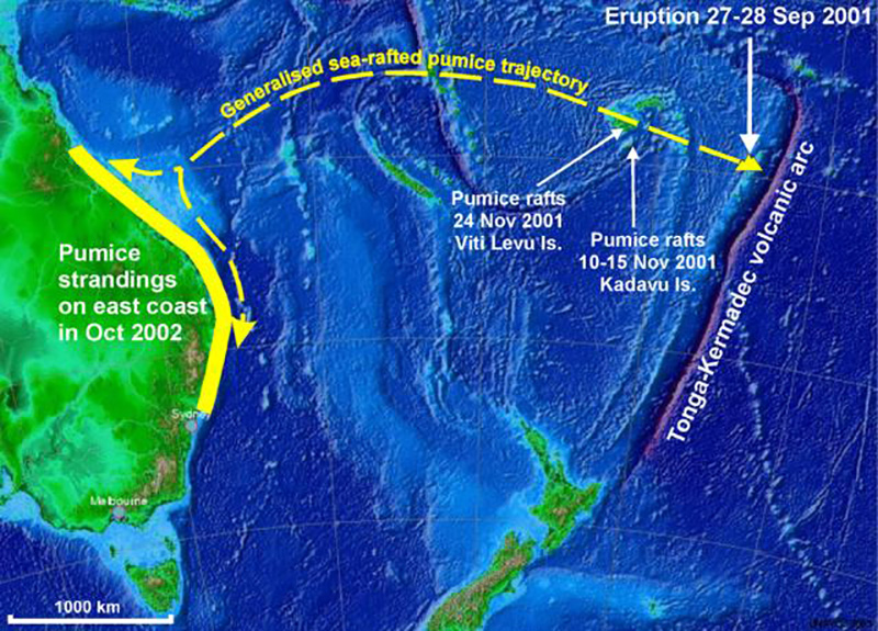 |
Figure 4. Map of the southwest Pacific Ocean showing the location of the unnamed volcano in the Tofua volcanic arc that erupted in September-October 2001 producing the pumice rafts. The general dispersal trajectory of the sea-rafted pumice is shown by the dashed line, and the pumice reached the eastern Australian coastline ~ 1 year after the eruption. Courtesy of Scott Bryan. |
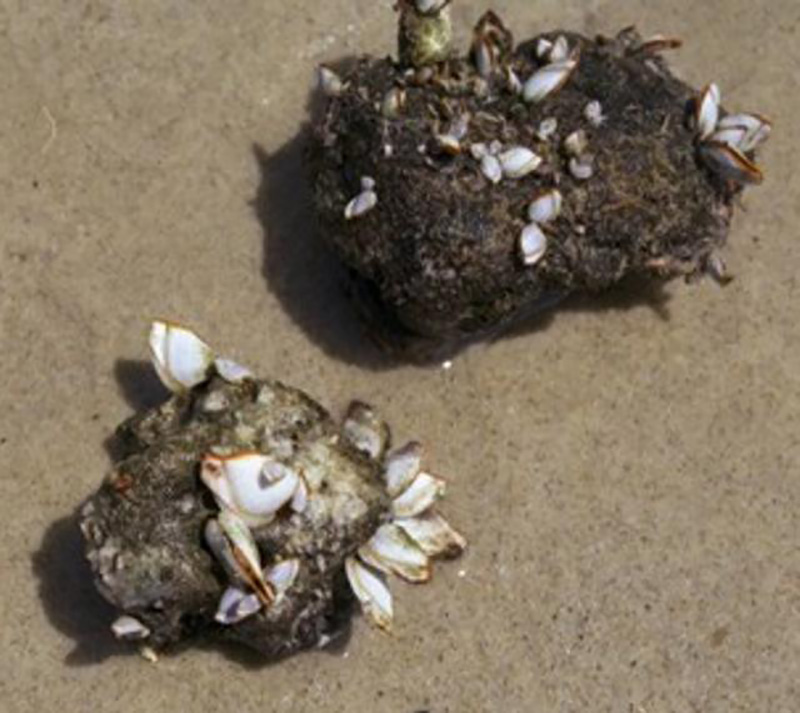 |
Figure 5. Closeup of beached pumice clasts from the unnamed volcano in the Tofua volcanic arc fouled by algae and goose barnacles (Lepas pectinata). Courtesy of Scott Bryan. |
The pumice have a low phenocryst content (< 5% modal) with the phenocryst assemblage consisting of calcic plagioclase (An88-74), pigeonite (En45 Fs46 Wo9), augite (En35 Fs29 Wo36), and titanomagnetite. Preliminary petrographic observations in dicate that the pumice is compositionally homogenous, although there is considerable variation in vesicularity within and between clasts. Tubed pumice is a minor but distinctive clast type. The pumice, like previously stranded pumice on the Great Barrier Reef (Bryan, 1968, 1971), is low-K dacite in composition (table 2), characterized by low alkalis and high iron and silica. This composition is similar to other pumice-forming eruptions from the Tonga region (Bryan, 1968).
Table 2. Major element data on sea-rafted pumice clasts from eastern Australia, 2002. Samples HI1 and GC1: major element data for whole pumice clasts determined by the atomic absorption method of silicate rock analysis using Inductively-Coupled Plasma-Atomic Emission Spectroscopy (ICP-AES) at the University of Queensland. Samples P1 and P2 (n=3 for both): averaged pumice glass compositions analysed at the Centre for Microscopy & Microanalysis, University of Queensland, using a JEOL 8800-L (wavelength dispersive) electron microprobe. Analyses were performed with an accelerating voltage of 15 kV and with a probe current of 15 nA and a probe diameter of 10 microns to avoid volatilisation of alkali elements. Courtesy of Scott Bryan and Alex Cook.
| Element | HI1 | GC1 | P1 | P2 |
| SiO2 | 71.30 | 65.90 | 66.84 | 67.33 |
| TiO2 | 0.36 | 0.58 | 0.51 | 0.50 |
| Al2O3 | 12.80 | 12.31 | 12.29 | 12.16 |
| Fe2O3^T | 5.50 | 9.88 | -- | -- |
| FeO^T | -- | -- | 8.05 | 8.04 |
| MnO | 0.10 | 0.18 | 0.16 | 0.15 |
| MgO | 1.07 | 1.43 | 0.93 | 0.92 |
| CaO | 4.34 | 5.77 | 5.40 | 5.23 |
| Na2O | 3.45 | 3.20 | 2.71 | 2.80 |
| K2O | 0.90 | 0.60 | 0.71 | 0.72 |
| P2O5 | 0.18 | 0.15 | 0.18 | 0.20 |
| BaO | -- | -- | 0.03 | 0.05 |
| SrO | -- | -- | 0.17 | 0.16 |
| LOI | 0.92 | 1.87 | -- | -- |
| Raw Total | 99.50 | 99.80 | 97.99 | 98.27 |
References. Bryan, W.B., 1968, Low-potash dacite drift pumice from the Coral Sea: Geological Magazine, v. 105, p. 431-439.
Bryan, W.B., 1971, Coral Sea drift pumice stranded on Eua Island, Tonga, in 1969: Geological Society of America Bulletin, v. 82, p. 2799-2812.
Information Contacts: Scott Bryan, Department of Geology & Geophysics, Yale University, PO Box 208109, New Haven CT 06520 8109 USA; Alex Cook, Queensland Museum, PO Box 3300, South Brisbane, Queensland 4101 Australia.
Bathymetric survey locates vent area and maps 2001 pumice deposits
An echo sounding depth survey of a recently active unnamed volcanic seamount (volcano number 0403-091) ~50 km NW of Vava'u was undertaken on 23 February 2007. The seamount is located within a roughly N-S segment of the submerged Tofua volcanic arc on a relatively broad plateau of less than 1,000 m depth, upon which five other seamounts rising to depths of 100 m are indicated on current bathymetric maps. One seamount indicated to shoal to depths of ~270 m, based on a reported spot depth recording in 1965, may correspond to this volcano.
No depth soundings were recorded at the previously described location of this volcano, with reported depths greater than 91 m. About 1.85 km (~1 nautical mile) to the NW, an area of shallow water (61-40 m) was mapped (figure 6). A relatively flat-topped seamount occurs with a maximum length of ~1.2 km (NW-SE) and 0.83 km width (NE-SW); much of the summit region is at or above 53 m below sea level. Two domal peaks cap the seamount and flank a depression on the E side. In profile, the seamount is steep-flanked, descending to water depths below 61 m over very short horizontal distances.
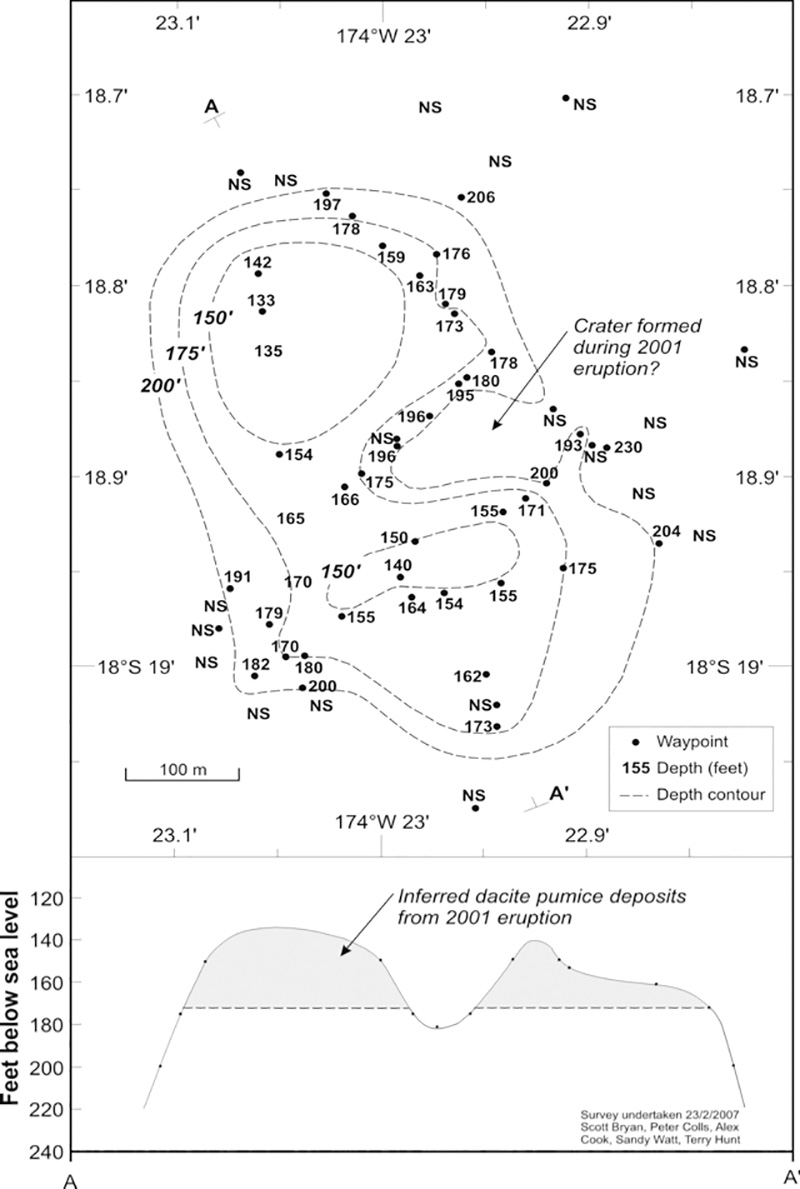 |
Figure 6. Bathymetric map and cross section of the unnamed Tongan seamount (volcano number 0403-091). NS: no depth sounding (ie. beyond depth-sounder range). Courtesy of Scott Bryan. |
Two peaked areas on the seamount summit are inferred to represent pumice and other juvenile dacitic deposits from the 2001 eruption (BGVN 26:11 and 27:01). The broader domal area on the NW side would be consistent with maximum pumice deposition in response to NW-directed wind and ocean currents at the time of eruption and the dispersal of pumice rafts. Based on the summit profiles, at least 12 m of juvenile material erupted during the 2001 eruption may have accumulated on the summit. The prominent depression on the E side of the summit may therefore correspond to the vent area of the 2001 eruption, where crater floor depths are more than 61 m below sea level. The bathymetric survey indicates that the 2001 submarine dacitic explosive eruption occurred in shallow water depths (< 100 m).
General References. Bryan, S.E., 2007, Preliminary Report: Field investigation of Home Reef volcano and Unnamed Seamount 0403-091: Unpublished Report for Ministry of Lands, Survey, Natural Resources and Environment, Tonga, 9 p.
Bryan, S.E., Cook, A., Evans, J., Colls, P., Lawrence, M., Wells, M., Jell, J.S., Greig, A., and Leslie, R., 2004, Pumice rafting and faunal dispersion during 2001-2002 in the southwest Pacific: record of a dacitic submarine explosive eruption from Tonga: Earth and Planetary Science Letters, v. 227, p. 135-154.
Taylor, P.W., 2002, Volcanic hazards assessment following the September-October 2001 eruption of a previously unrecognised submarine volcano W of Vava'u, Kingdom of Tonga: Australian Volcanological Investigations, AVI Occasional Report No. 02/01, p. 1-7.
Information Contacts: Scott Bryan, School of Earth Sciences & Geography, Kingston Univ., Kingston Upon Thames, Surrey KT1 2EL, United Kingdom; Peter Colls, School of Physical Sciences, Univ. of Queensland, St Lucia, Queensland 4072, Australia.
Submarine eruption in early August creates pumice rafts that drifted west to Fiji
Large areas of floating pumice, termed rafts, were encountered by sailors in the northern Tonga region approximately 80 km NW of Vava'u starting around 9 August 2019; the pumice reached the western islands of Fiji by 9 October (figure 7). Pumice rafts are floating masses of individual clasts ranging from millimeters to meters in diameter. The pumice clasts form when silicic magma is degassing, forming bubbles as it rises to the surface, which then rapidly cools to form solid rock. The isolated vesicles formed by the bubbles provide buoyancy to the rock and in turn, the entire pumice raft. These rafts are spread and carried by currents across the ocean; rafts originating in the Tonga area can eventually reach Australia. This report summarizes the pumice raft eruption from early August 2019 using witness accounts and satellite images (acquisition dates are given in UTC). Pending further research, the presumed source is the unnamed Tongan seamount (volcano number 243091) about 45 km NW of Vava'u, the origin of an earlier pumice raft produced during an eruption in 2001.
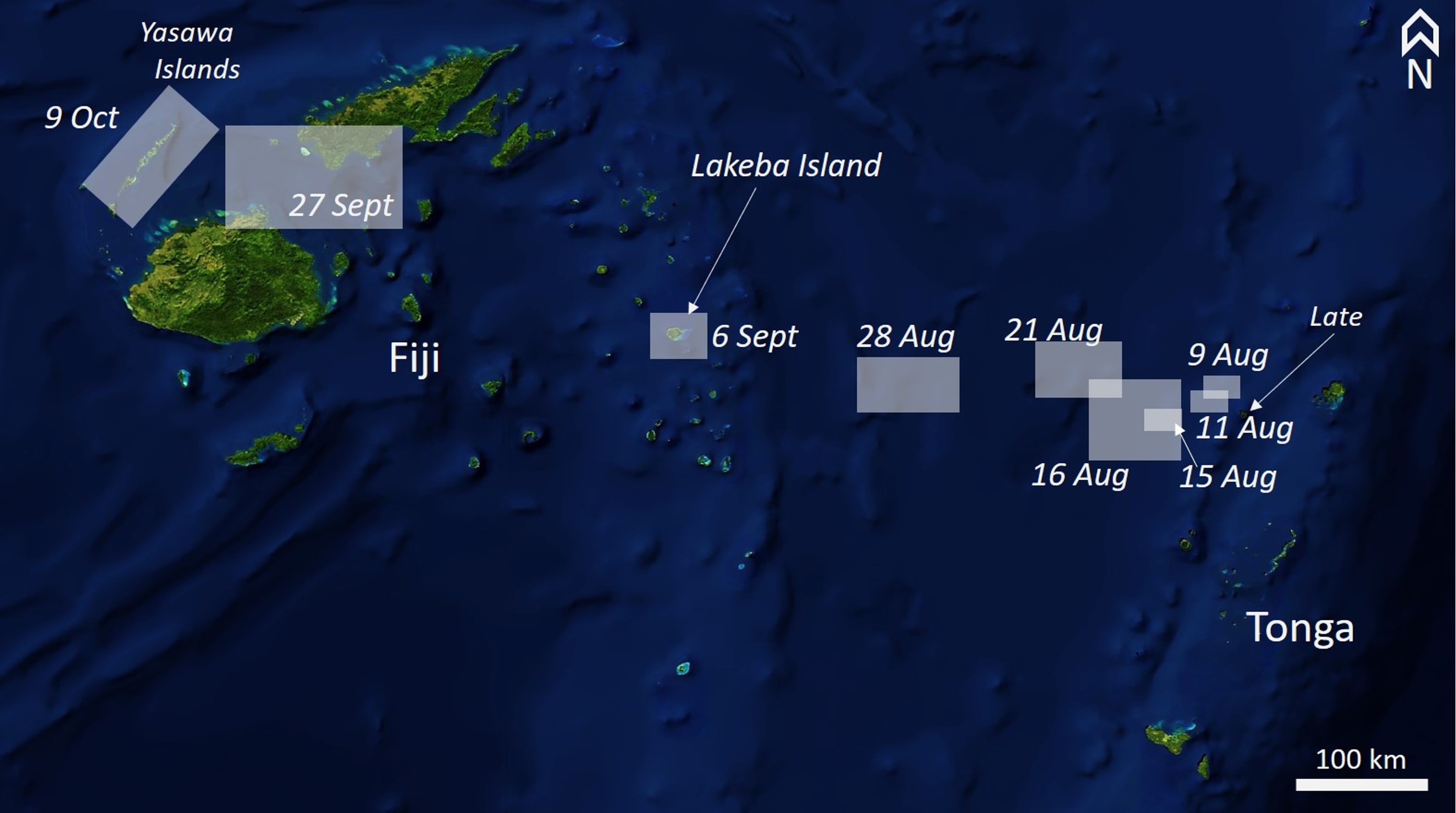 |
Figure 7. The path of the pumice from the unnamed Tongan seamount from 9 August to 9 October 2019 based on eye-witness accounts and satellite data discussed below, as well as additional Aqua/MODIS satellite images from NASA Worldview. Blue Marble MODIS/NASA Earth Observatory base map courtesy of NASA Worldview. |
The first sighting of pumice was around 1430 on 9 August NW of Vava'u in Tonga (18° 22.068' S, 174° 50.800' W), when Shannon Lenz and Tom Whitehead on board SV Finely Finished initially encountered isolated rocks and smaller streaks of pumice clasts. The area covered by rock increasing to a raft with an estimated thickness of at least 15 cm that extended to the horizon in different directions, and which took 6-8 hours to cross (figure 8). There was no sulfur smell and the sound was described as a "cement mixer, especially below deck." There was also no plume or incandescence observed. Their video, posted to YouTube on 17 August, showed a thin surface layer of cohesive interconnected irregular streaks of pumice with the ocean surface still visible between them. Later footage showed a continuous, undulating mass of pumice entirely covering the ocean surface. Larger clasts are visible scattered throughout the raft. The pumice raft was visible in satellite imagery on this day NW of Late Island (figure 9). By 11 August the raft had evolved into a largely linear feature with smaller rafts to the SW (figure 10). Approximately four hours later, about 15 km to the WSW, Rachel Mackie encountered the pumice. Initially the pumice was "ribbons several hundred meters long and up to 20m wide. It was quite fine and like a slick across the surface of the water." By 2130 they were surrounded by the pumice, and around 25 km away the smell of sulfur was noted.
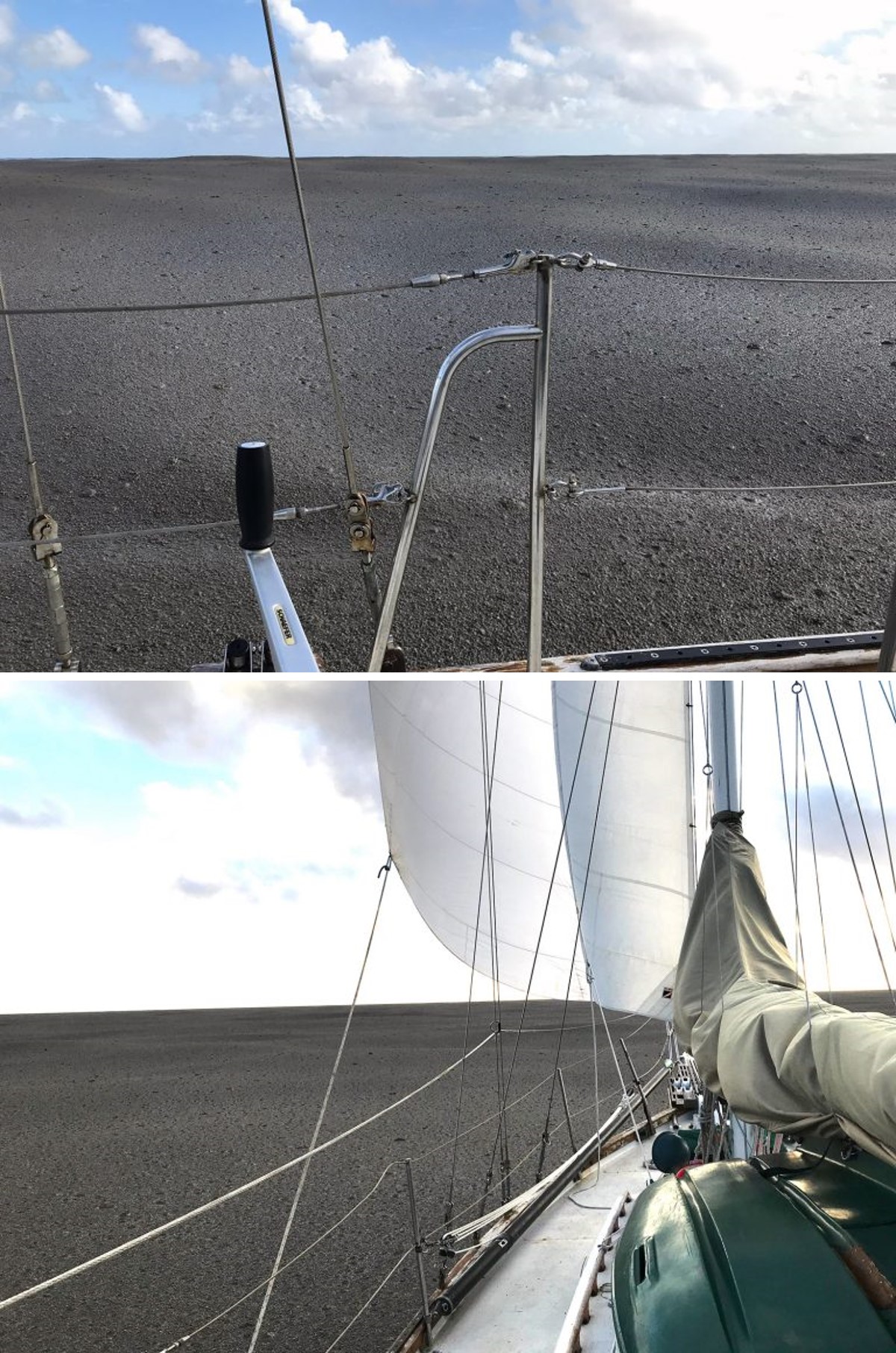 |
Figure 8. The pumice raft from the unnamed Tongan seamount on 9 August 2019 taken by Shannon Lenz and Tom Whitehead on board SV Finely Finished. The photos show the pumice raft extending to the horizon in different directions. Scattered larger clasts protrude from the relatively smooth surface that entirely obscures the ocean surface. Courtesy of Shannon Lenz and Tom Whitehead via noonsite. |
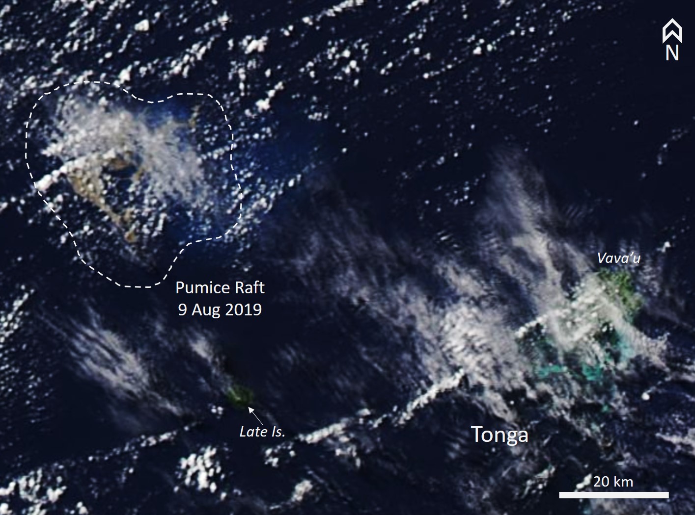 |
Figure 9. The pumice raft from the unnamed Tongan seamount on 9 August 2019 (UTC) can be seen NW of Late Island of Tonga in this Aqua/MODIS satellite image. The dashed white line encompasses the visible pumice. The location of the pumice in this image is shown in figure 7. Courtesy of NASA WorldView. |
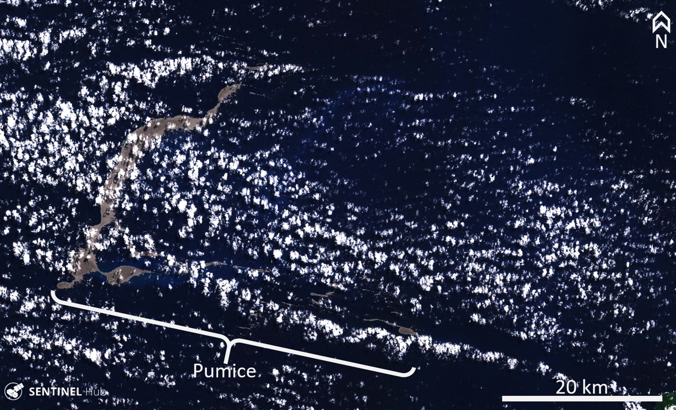 |
Figure 10. The Sentinel-2 satellite first imaged the pumice from the unnamed Tongan seamount on 11 August 2019 (UTC). This image indicates the pumice distribution with the main raft towards the W and the easternmost area of pumice approximately 45 km away. The eastern tip of the pumice area is located approximately 30 km WNW of Lake islands in Tonga. The location of the pumice in this image is shown in figure 7. Natural color (bands 4, 3, 2) Sentinel-2 satellite image courtesy of Sentinel Hub Playground. |
Michael and Larissa Hoult aboard the catamaran ROAM encountered the raft on 15 August (figure 11). They initially saw isolated clasts ranging from marble to tennis ball size (15-70 mm) at 18° 46′S, 174° 55'W. At around 0700 UTC (1900 local time) they noted the smell of sulfur at 18° 55′S, 175° 21′W, and by 0800 UTC they were immersed in the raft with visible clasts ranging from marble to basketball (25 cm) sizes. At this point the raft was entirely obscuring the ocean surface. On 16 and 21 August the pumice continued to disperse and drift NW (figures 12 and 13). On 20 August Scott Bryan calculated an average drift rate of around 13 km/day, with the pumice on this date about 164 km W of the unnamed seamount.
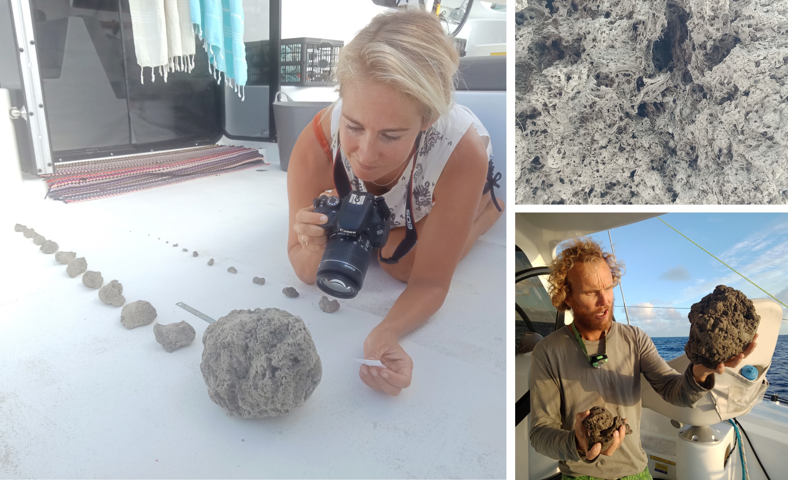 |
Figure 11. Images of pumice from the unnamed Tongan seamount encountered by Michael and Larissa Hoult aboard the catamaran Roam on 15 August. Left: Larissa takes photographs with scale of pumice clasts; top right: a closeup of a pumice clast showing the vesicle network preserving the degassing structures of the magma; bottom left: Michael holding several larger pumice clasts. The location of their encounter with the pumice is shown in figure 7. Courtesy of SailSurfROAM. |
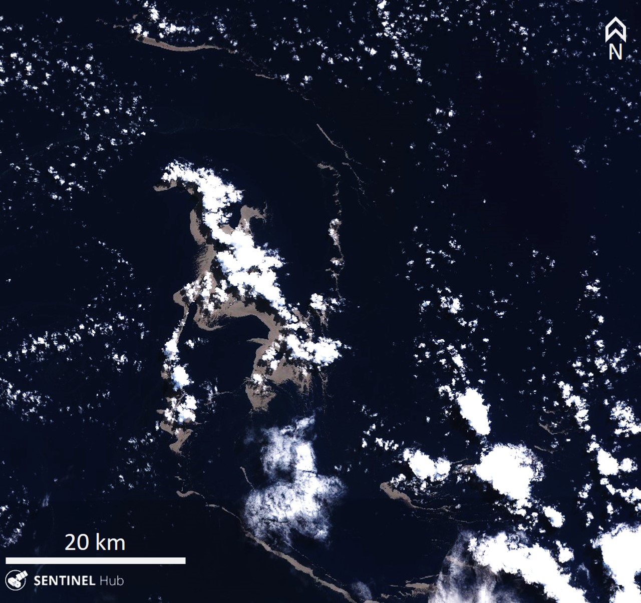 |
Figure 12. The pumice from the unnamed Tongan seamount (volcano number 243091) on 16 August 2019 UTC. The location of the pumice in this image is shown in figure 7. Natural color (bands 4, 3, 2) Sentinel-2 satellite image courtesy of Sentinel Hub Playground. |
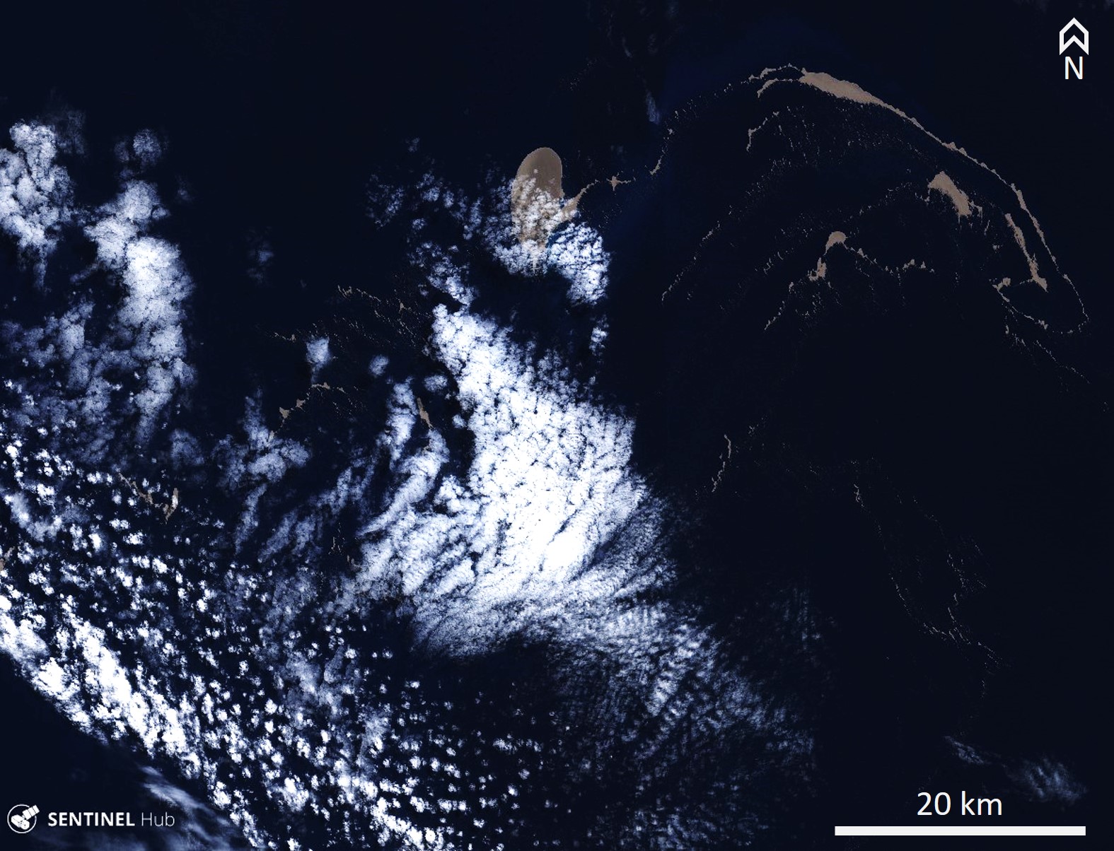 |
Figure 13. On 21 August 2019 (UTC) the pumice from the unnamed Tongan seamount (volcano number 243091) had drifted at least 120 km WNW of Late Island in Tonga. The location of the pumice in this image is shown in figure 7. Natural color (bands 4, 3, 2) Sentinel-2 satellite image courtesy of Sentinel Hub Playground. |
An online article published by Brad Scott at GeoNet on 9 September reported the preliminary size of the raft to be 60 km2, significantly smaller than the 2012 Havre seamount pumice raft that was 400 km2. Satellite identification of pumice-covered areas by GNS scientists showed the material moving SSW through 14 August (figure 14).
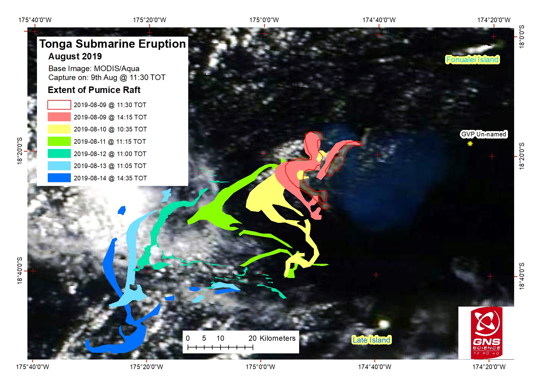 |
Figure 14. A compilation of mapped pumice raft extents from 9 August (red line) through to 14 August (dark blue) from Suomi NPP, Terra, Aqua, and Sentinel-2 satellite images. The progression of the pumice raft is towards the SW. Courtesy of Salman Ashraf, GNS Science. |
On 5 September the Maritime Safety Authority of Fiji (MSAF) issued a notice to mariners stating that the pumice was sighted in the vicinity of Lakeba, Oneata, and Aiwa Islands and was moving to the W. On 6 September a Planet Labs satellite image shows pumice encompassing the Fijian island of Lakeba over 450 km W of the Tongan islands (figure 15). The pumice entered the lagoon within the barrier reef and drifted around the island to continue towards the W. The pumice was imaged by the Landsat 8 satellite on 26 September as it moved through the Fijian islands, approximately 760 km away from its source (figure 16). The pumice is segmented into numerous smaller rafts of varying sizes that stretch over at least 140 km. On 12 September the Fiji Sun reported that the pumice had reached some of the Lau islands and was thick enough near the shore for people to stand on it.
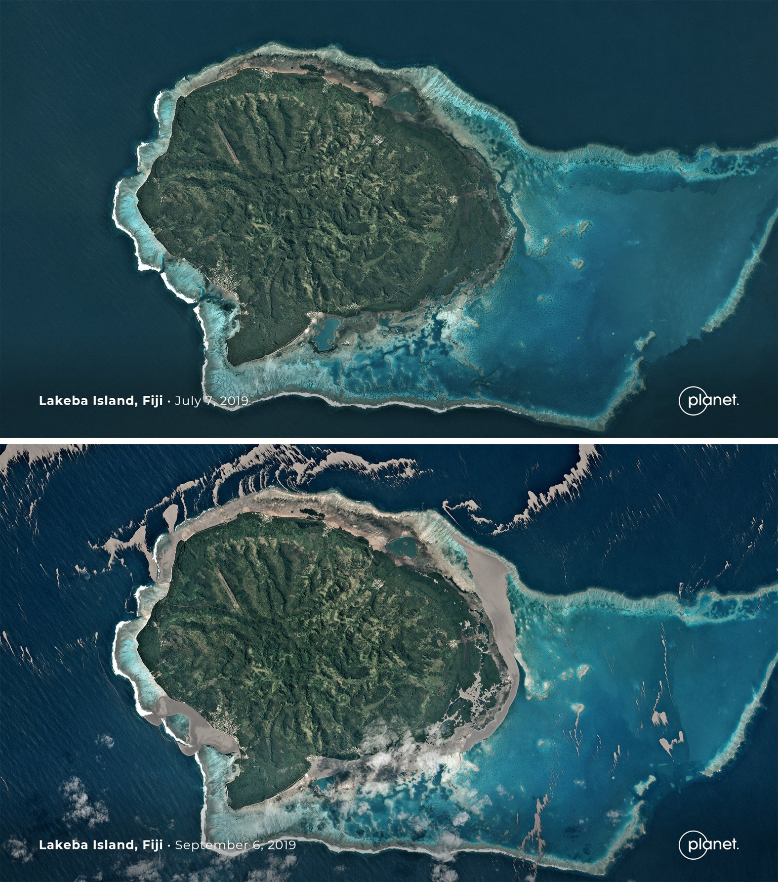 |
Figure 15. Planet Labs satellite images show Lakeba Island to the E of the larger Viti Levu Island in the Fiji archipelago. The top image shows the island on 7 July 2019 prior to the pumice raft from the unnamed Tongan seamount. The bottom image shows pumice on the sea surface almost entirely encompassing the island on 6 September. The location of the pumice in this image is shown in figure 7. Courtesy of Planet Labs. |
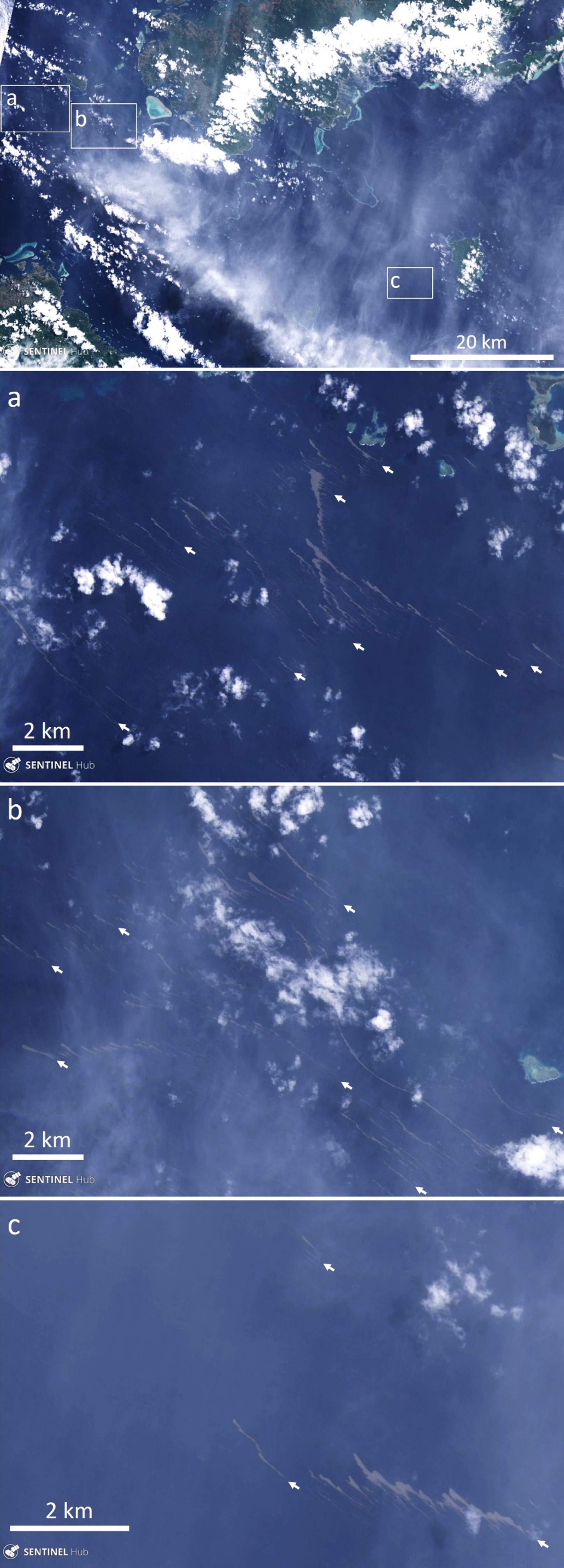 |
Figure 16. Landsat 8 satellite images show the visible extent of the unnamed seamount pumice on 26 September 2019 (UTC), up to approximately 760 km from the Tongan islands. The pumice seen here extends over a distance of 140 km. The top image shows the locations of the other three images in the white boxes, with a, b, and c indicating the locations. White arrows point to examples of the light brown pumice rafts in these images, seen through light cloud cover. The island in the lower right is Koro Island, the island to the lower left is Viti Levu, and the island to the top right is Vanua Levu. The location of the pumice in this image is shown in figure 7. Landsat 8 true color-pansharpened satellite images courtesy of Sentinel Hub. |
Pumice had reached the Yasawa islands in western Fiji by 29 September and was beginning to fill the eastern bays (figure 17). By 9 October bays had been filled out to 500-600 m from the shore, and pumice had also passed through the islands to continue towards the W (figure 18). At this point the pumice beyond the islands had broken up into linear segments that continued towards the NW.
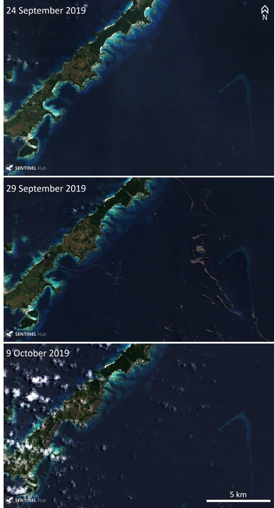 |
Figure 17. These Sentinel-2 satellite images show the pumice from the unnamed Tongan seamount drifting towards the Yasawa islands of Fiji. The 24 September 2019 (UTC) image shows the beaches without the pumice, the 29 September image shows pumice drifting westward towards the islands, and the 9 October image shows the bays partly filled with pumice out to a maximum of 500-600 m from the shore. These islands are approximately 850 km from the Tongan islands. The Yasawa islands coastline impacted by the pumice shown in these images stretches approximately 48 km. The location of the pumice in this image is shown in figure 7. Sentinel-2 natural color (bands 4, 3, 2) satellite images courtesy of Sentinel Hub. |
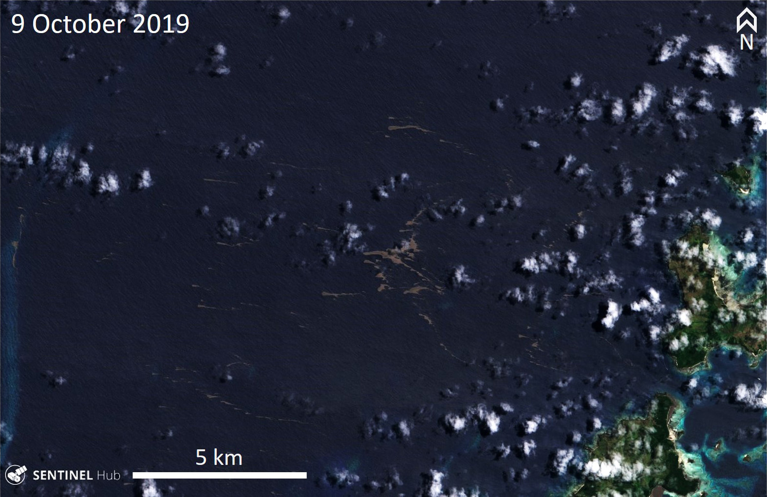 |
Figure 18. This Sentinel-2 satellite image acquired on 9 October 2019 (UTC) shows expanses of pumice from the unnamed Tongan seamount that passed through the Yasawa islands of Fiji and was continuing NWW, seen in the center of the image. The location of the pumice in this image is shown in figure 7. Sentinel-2 natural color (bands 4, 3, 2) satellite images courtesy of Sentinel Hub. |
Information Contacts: GNS Science, Wairakei Research Centre, Private Bag 2000, Taupo 3352, New Zealand (URL: http://www.gns.cri.nz/); Salman Ashraf, GNS Science, Wairakei Research Centre, Private Bag 2000, Taupo 3352, New Zealand (URL: http://www.gns.cri.nz/, https://www.geonet.org.nz/news/8RnSKdhaWOEABBIh0bHDj); Brad Scott, New Zealand GeoNet Project, a collaboration between the Earthquake Commission and GNS Science, Wairakei Research Centre, Private Bag 2000, Taupo 3352, New Zealand (URL: http://www.geonet.org.nz/, https://www.geonet.org.nz/news/8RnSKdhaWOEABBIh0bHDj); Scott Bryan, School of Earth, Environmental & Biological Sciences, Science and Engineering Faculty, Queensland University of Technology, R Block Level 2, 204, Gardens Point (URL: https://staff.qut.edu.au/staff/scott.bryan); Shannon Lenz and Tom Whitehead, SV Finely Finished (URL: https://www.noonsite.com/news/south-pacific-tonga-to-fiji-navigation-alert-dangerous-slick-of-volcanic-rubble/, YouTube: https://www.youtube.com/watch?v=PEsHLSFFQhQ); Michael and Larissa Hoult, Sail Surf ROAM (URL: https://www.facebook.com/sailsurfroam/); Rachel Mackie, OLIVE (URL: http://www.oliveocean.com/, https://www.facebook.com/rachel.mackie.718); Sentinel Hub Playground (URL: https://www.sentinel-hub.com/explore/sentinel-playground); Planet Labs, Inc. (URL: https://www.planet.com/); Fiji Sun (URL: https://fijisun.com.fj/2019/09/12/pumice-menace-hits-parts-of-lau-group/).
Additional details and pumice raft drift maps from the August 2019 submarine eruption
In the northern Tonga region, approximately 80 km NW of Vava’u, large areas of floating pumice, termed rafts, were observed starting as early as 7 August 2019. The area of these andesitic pumice rafts was initially 195 km2 with the layers measuring 15-30 cm thick and were produced 200 m below sea level (Jutzeler et al. 2020). The previous report (BGVN 44:11) described the morphology of the clasts and the rafts, and their general westward path from 9 August to 9 October 2019, with the first sighting occurring on 9 August NW of Vava’u in Tonga. This report updates details regarding the submarine pumice raft eruption in early August 2019 using new observations and data from Brandl et al. (2019) and Jutzeler et al. (2020).
The NoToVE-2004 (Northern Tonga Vents Expedition) research cruise on the RV Southern Surveyor (SS11/2004) from the Australian CSIRO Marine National Facility traveled to the northern Tonga Arc and discovered several submarine basalt-to-rhyolite volcanic centers (Arculus, 2004). One of these volcanic centers 50 km NW of Vava’u was the unnamed seamount (volcano number 243091) that had erupted in 2001 and again in 2019, unofficially designated “Volcano F” for reference purposes by Arculus (2004) and also used by Brandl et al. (2019). It is a volcanic complex that rises more than 1 km from the seafloor with a central 6 x 8.7 km caldera and a volcanic apron measuring over 50 km in diameter (figures 19 and 20). Arculus (2004) described some of the dredged material as “fresh, black, plagioclase-bearing lava with well-formed, glassy crusts up to 2cm thick” from cones by the eastern wall of the caldera; a number of apparent flows, lava or debris, were observed draping over the northern wall of the caldera.
|
Figure 19. Visualization of the unnamed submarine Tongan volcano (marked “Volcano F”) using bathymetric data to show the site of the 6-8 August 2020 eruption and the rest of the cone complex. Courtesy of Philipp Brandl via GEOMAR. |
|
Figure 20. Map of the unnamed submarine Tongan volcano using satellite imagery, bathymetric data, with shading from the NW. The yellow circle indicates the location of the August 2019 activity. Young volcanic cones are marked “C” and those with pit craters at the top are marked with “P.” Courtesy of Brandl et al. (2019). |
The International Seismological Centre (ISC) Preliminary Bulletin listed a particularly strong (5.7 Mw) earthquake at 2201 local time on 5 August, 15 km SSW of the volcano at a depth of 10 km (Brandl et al. 2019). This event was followed by six slightly lower magnitude earthquakes over the next two days.
Sentinel-2 satellite imagery showed two concentric rings originating from a point source (18.307°S 174.395°W) on 6 August (figure 21), which could be interpreted as small weak submarine plumes or possibly a series of small volcanic cones, according to Brandl et al. (2019). The larger ring is about 1.2 km in diameter and the smaller one measures 250 m. By 8 August volcanic activity had decreased, but the pumice rafts that were produced remained visible through at least early October (BGVN 44:11). Brandl et al. (2019) states that, due to the lack of continued observed activity rising from this location, the eruption was likely a 2-day-long event during 6-8 August.
|
Figure 21. Sentinel-2 satellite image of possible gas/vapor emissions (streaks) on 6 August 2019 drifting NW, which is the interpreted site for the unnamed Tongan seamount. The larger ring is about 1.2 km in diameter and the smaller one measures 250 m. Image using False Color (urban) rendering (bands 12, 11, 4); courtesy of Sentinel Hub Playground. |
The pumice was first observed on 9 August occurred up to 56 km from the point of origin, according to Jutzeler et al. (2020). By calculating the velocity (14 km/day) of the raft using three satellites, Jutzeler et al. (2020) determined the pumice was erupted immediately after the satellite image of the submarine plumes on 6 August (UTC time). Minor activity at the vent may have continued on 8 and 11 August (UTC time) with pale blue-green water discoloration (figure 22) and a small (less than 1 km2) diffuse pumice raft 2-5 km from the vent.
|
Figure 22. Sentinel-2 satellite image of the last visible activity occurring W of the unnamed submarine Tongan volcano on 8 August 2019, represented by slightly discolored blue-green water. Image using Natural Color rendering (bands 4, 3, 2) and enhanced with color correction; courtesy of Sentinel Hub Playground. |
Continuous observations using various satellite data and observations aboard the catamaran ROAM tracked the movement and extent of the pumice raft that was produced during the submarine eruption in early August (figure 23). The first visible pumice raft was observed on 8 August 2019, covering more than 136.7 km2 between the volcanic islands of Fonualei and Late and drifting W for 60 km until 9 August (Brandl et al. 2019; Jutzeler 2020). The next day, the raft increased to 167.2-195 km2 while drifting SW for 74 km until 14 August. Over the next three days (10-12 August) the size of the raft briefly decreased in size to less than 100 km2 before increasing again to 157.4 km2 on 14 August; at least nine individual rafts were mapped and identified on satellite imagery (Brandl et al. 2019). On 15 August sailing vessels observed a large pumice raft about 75 km W of Late Island (see details in BGVN 44:11), which was the same one as seen in satellite imagery on 8 August.
|
Figure 23. Map of the extent of discolored water and the pumice raft from the unnamed submarine Tongan volcano between 8 and 14 August 2019 using imagery from NASA’s MODIS, ESA’s Sentinel-2 satellite, and observations from aboard the catamaran ROAM (BGVN 44:11). Back-tracing the path of the pumice raft points to a source location at the unnamed submarine Tongan volcano. Courtesy of Brandl et al. (2019). |
By 17 August high-resolution satellite images showed an area of large and small rafts measuring 222 km2 and were found within a field of smaller rafts for a total extent of 1,350 km2, which drifted 73 km NNW through 22 August before moving counterclockwise for three days (figure f; Jutzeler et al., 2020). Small pumice ribbons encountered the Oneata Lagoon on 30 August, the first island that the raft came into contact (Jutzeler et al. 2020). By 2 September, the main raft intersected with Lakeba Island (460 km from the source) (figure 24), breaking into smaller ribbons that started to drift W on 8 September. On 19 September the small rafts (less than 100 m x less than 2 km) entered the strait between Viti Levu and Vanua Levu, the two main islands of Fiji, while most of the others were stranded 60 km W in the Yasawa Islands for more than two months (Jutzeler et al., 2020).
|
Figure 24. Time-series map of the raft dispersal from the unnamed submarine Tongan volcano using multiple satellite images. A) Map showing the first days of the raft dispersal starting on 7 August 2019 and drifting SW from the vent (marked with a red triangle). Precursory seismicity that began on 5 August is marked with a white star. By 15-17 August the raft was entrained in an ocean loop or eddy. The dashed lines represent the path of the sailing vessels. B) Map of the raft dispersal using high-resolution Sentinel-2 and -3 imagery. Two dispersal trails (red and blue dashed lines) show the daily dispersal of two parts of the raft that were separated on 17 August 2019. Courtesy of Jutzeler et al. (2020). |
References: Arculus R J, SS2004/11 shipboard scientists, 2004. SS11/2004 Voyage Summary: NoToVE-2004 (Northern Tonga Vents Expedition): submarine hydrothermal plume activity and petrology of the northern Tofua Arc, Tonga. https://www.cmar.csiro.au/data/trawler/survey_details.cfm?survey=SS200411
Brandl P A, Schmid F, Augustin N, Grevemeyer I, Arculus R J, Devey C W, Petersen S, Stewart M , Kopp K, Hannington M D, 2019. The 6-8 Aug 2019 eruption of ‘Volcano F’ in the Tofua Arc, Tonga. Journal of Volcanology and Geothermal Research: https://doi.org/10.1016/j.jvolgeores.2019.106695
Jutzeler M, Marsh R, van Sebille E, Mittal T, Carey R, Fauria K, Manga M, McPhie J, 2020. Ongoing Dispersal of the 7 August 2019 Pumice Raft From the Tonga Arc in the Southwestern Pacific Ocean. AGU Geophysical Research Letters: https://doi.orh/10.1029/2019GL086768.
Information Contacts: Jan Steffen, Communication and Media, GEOMAR Helmholtz Centre for Ocean Research, Kiel, Germany; Sentinel Hub Playground (URL: https://www.sentinel-hub.com/explore/sentinel-playground).
|
|
||||||||||||||||||||||||||
There is data available for 2 confirmed eruptive periods.
2019 Aug 6 - 2019 Aug 8 Confirmed Eruption (Explosive / Effusive) VEI: 3
| Episode 1 | Eruption (Explosive / Effusive) | |||||||||||||||||||
|---|---|---|---|---|---|---|---|---|---|---|---|---|---|---|---|---|---|---|---|
| 2019 Aug 6 - 2019 Aug 8 | Evidence from Observations: Satellite (visual) | ||||||||||||||||||
| Large pumice rafts were encountered by sailors in the northern Tonga region approximately 80 km NW of Vava'u starting around 9 August 2019. One sailing vessel took 6-8 hours to cross a raft with an estimated thickness of at least 15 cm that extended to the horizon in different directions. Sailors on a catamaran described pumice clasts ranging from 15 mm to 25 cm in diameter on 15 August. One analysis suggested that the raft covered an area of 60 km2. By early September pumice had traveled 450 km W to Lakeba Island, Fiji. | |||||||||||||||||||
|
List of 2 Events for Episode 1
|
|||||||||||||||||||
2001 Sep 27 - 2001 Sep 28 (?) Confirmed Eruption (Explosive / Effusive) VEI: 2
| Episode 1 | Eruption (Explosive / Effusive) | |||||||||||||||||||||||||||||
|---|---|---|---|---|---|---|---|---|---|---|---|---|---|---|---|---|---|---|---|---|---|---|---|---|---|---|---|---|---|
| 2001 Sep 27 - 2001 Sep 28 (?) | Evidence from Observations: Reported | ||||||||||||||||||||||||||||
| The site of the eruption is along a NNE-SSW-trending submarine plateau south of Fonualei with an approximate depth of 300 m. T-phase waves were recorded on 27-28 September 2001, and on the 27th local fishermen observed an ash-rich eruption column that rose above the ocean surface. No eruptive activity was reported after the 28th, but water discoloration was documented during the following month. In early November pumice rafts and strandings were reported along the coast of Kadavu and Viti Levu in the Fiji Islands, and a year after the eruption pumice reached the eastern shore of Australia. | |||||||||||||||||||||||||||||
|
List of 4 Events for Episode 1
|
|||||||||||||||||||||||||||||
The Global Volcanism Program has no synonyms or subfeatures listed for Unnamed.
The Global Volcanism Program has no photographs available for Unnamed.
The following 1 samples associated with this volcano can be found in the Smithsonian's NMNH Department of Mineral Sciences collections, and may be availble for research (contact the Rock and Ore Collections Manager). Catalog number links will open a window with more information.
| Catalog Number | Sample Description | Lava Source | Collection Date |
|---|---|---|---|
| NMNH 117278 | Drift Pumice | -- | -- |
| Copernicus Browser | The Copernicus Browser replaced the Sentinel Hub Playground browser in 2023, to provide access to Earth observation archives from the Copernicus Data Space Ecosystem, the main distribution platform for data from the EU Copernicus missions. |
| MIROVA | Middle InfraRed Observation of Volcanic Activity (MIROVA) is a near real time volcanic hot-spot detection system based on the analysis of MODIS (Moderate Resolution Imaging Spectroradiometer) data. In particular, MIROVA uses the Middle InfraRed Radiation (MIR), measured over target volcanoes, in order to detect, locate and measure the heat radiation sourced from volcanic activity. |
| MODVOLC Thermal Alerts | Using infrared satellite Moderate Resolution Imaging Spectroradiometer (MODIS) data, scientists at the Hawai'i Institute of Geophysics and Planetology, University of Hawai'i, developed an automated system called MODVOLC to map thermal hot-spots in near real time. For each MODIS image, the algorithm automatically scans each 1 km pixel within it to check for high-temperature hot-spots. When one is found the date, time, location, and intensity are recorded. MODIS looks at every square km of the Earth every 48 hours, once during the day and once during the night, and the presence of two MODIS sensors in space allows at least four hot-spot observations every two days. Each day updated global maps are compiled to display the locations of all hot spots detected in the previous 24 hours. There is a drop-down list with volcano names which allow users to 'zoom-in' and examine the distribution of hot-spots at a variety of spatial scales. |
|
WOVOdat
Single Volcano View Temporal Evolution of Unrest Side by Side Volcanoes |
WOVOdat is a database of volcanic unrest; instrumentally and visually recorded changes in seismicity, ground deformation, gas emission, and other parameters from their normal baselines. It is sponsored by the World Organization of Volcano Observatories (WOVO) and presently hosted at the Earth Observatory of Singapore.
GVMID Data on Volcano Monitoring Infrastructure The Global Volcano Monitoring Infrastructure Database GVMID, is aimed at documenting and improving capabilities of volcano monitoring from the ground and space. GVMID should provide a snapshot and baseline view of the techniques and instrumentation that are in place at various volcanoes, which can be use by volcano observatories as reference to setup new monitoring system or improving networks at a specific volcano. These data will allow identification of what monitoring gaps exist, which can be then targeted by remote sensing infrastructure and future instrument deployments. |
| Volcanic Hazard Maps | The IAVCEI Commission on Volcanic Hazards and Risk has a Volcanic Hazard Maps database designed to serve as a resource for hazard mappers (or other interested parties) to explore how common issues in hazard map development have been addressed at different volcanoes, in different countries, for different hazards, and for different intended audiences. In addition to the comprehensive, searchable Volcanic Hazard Maps Database, this website contains information about diversity of volcanic hazard maps, illustrated using examples from the database. This site is for educational purposes related to volcanic hazard maps. Hazard maps found on this website should not be used for emergency purposes. For the most recent, official hazard map for a particular volcano, please seek out the proper institutional authorities on the matter. |
| IRIS seismic stations/networks | Incorporated Research Institutions for Seismology (IRIS) Data Services map showing the location of seismic stations from all available networks (permanent or temporary) within a radius of 0.18° (about 20 km at mid-latitudes) from the given location of Unnamed. Users can customize a variety of filters and options in the left panel. Note that if there are no stations are known the map will default to show the entire world with a "No data matched request" error notice. |
| UNAVCO GPS/GNSS stations | Geodetic Data Services map from UNAVCO showing the location of GPS/GNSS stations from all available networks (permanent or temporary) within a radius of 20 km from the given location of Unnamed. Users can customize the data search based on station or network names, location, and time window. Requires Adobe Flash Player. |
| DECADE Data | The DECADE portal, still in the developmental stage, serves as an example of the proposed interoperability between The Smithsonian Institution's Global Volcanism Program, the Mapping Gas Emissions (MaGa) Database, and the EarthChem Geochemical Portal. The Deep Earth Carbon Degassing (DECADE) initiative seeks to use new and established technologies to determine accurate global fluxes of volcanic CO2 to the atmosphere, but installing CO2 monitoring networks on 20 of the world's 150 most actively degassing volcanoes. The group uses related laboratory-based studies (direct gas sampling and analysis, melt inclusions) to provide new data for direct degassing of deep earth carbon to the atmosphere. |
| Large Eruptions of Unnamed | Information about large Quaternary eruptions (VEI >= 4) is cataloged in the Large Magnitude Explosive Volcanic Eruptions (LaMEVE) database of the Volcano Global Risk Identification and Analysis Project (VOGRIPA). |
| EarthChem | EarthChem develops and maintains databases, software, and services that support the preservation, discovery, access and analysis of geochemical data, and facilitate their integration with the broad array of other available earth science parameters. EarthChem is operated by a joint team of disciplinary scientists, data scientists, data managers and information technology developers who are part of the NSF-funded data facility Integrated Earth Data Applications (IEDA). IEDA is a collaborative effort of EarthChem and the Marine Geoscience Data System (MGDS). |

