Submarine volcanism and lava flows on the Northeast Lau Spreading Center
The following is the first Bulletin report about this submarine volcanic area in the S part of the Northeast Lau Spreading Center (NELSC) (figure 1). An informal paper by Resing and others (2009) reported that two recent eruption sites were discovered in the NE Lau Basin during a November 2008 scientific expedition aboard the research vessel RV Thompson. The first eruption site discovered was within the NELSC and contained two active submarine volcanoes, Tafu and Maka (figure 2). During the expedition a conductivity/temperature/depth (CTD)/rosette package was used to measure the physical and chemical nature of hydrothermal systems, and the Thompson's multibeam sonar provided high resolution bathymetry and seafloor backscatter imagery. Another expedition in May 2009 revealed fresh lava flows near the Maka cone.
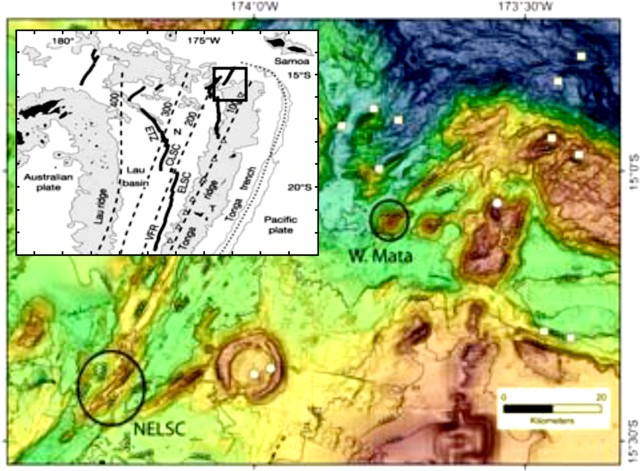 |
Figure 1. Bathymetric map of NE Lau area showing two eruption areas (circled) discovered during the 2009 expedition, West Mata and NELSC where volcanoes Tafu and Maka are located. Contour interval 500 m. Inset location map shows the Fiji Islands (~ 860 km WNW) and Samoa (~ 270 km NE), along with the East Lau Spreading Center (ELSC), Central Lau Spreading Center (CLSC), and Fonulalei Spreading Center (FSC). Courtesy of Resing and others (2009). |
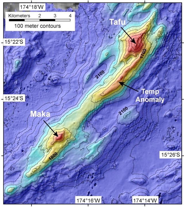 |
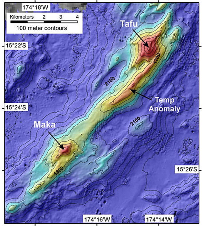
Figure 2. Multibeam bathymetry of the Tafu-Maka ridge eruption site along the southern segment of the Northeast Lau Spreading Center (NELSC). Contour interval 100 m. Courtesy of Resing and others (2009). |
Expedition during 13-28 November 2008. The Tafu-Maka eruption site was discovered on the neovolcanic zone of the southernmost segment of the NELSC at a depth of ~1,650 m depth (figure 1). Plumes characterized by high levels of turbidity, concentrations of volcanic glass shards, large temperature anomalies, pH anomalies, hydrogen, and methane were detected up to 800 m above the seafloor at several locations above this ridge between the Tafu and Maka features (figure 2). Volcanic glass and other clastic material were present in filtered particulate samples from the plume. Such high-rising plumes in this type of hydrographic setting have been reliable indicators of massive hydrothermal discharge associated with seafloor eruptions. The observed levels of hydrogen in plumes have only been associated with the interaction of molten rock and seawater. In addition, near-bottom temperature anomalies of ~0.5°C, measured with the CTDO (conductivity/temperature/depth/oxygen) package, coincided with high levels of H2 and CH4 on the neovolcanic ridge north of Maka.
Prior work in the area (German and others, 2006) had located an intense hydrothermal plume over Maka, and this plume was relocated and sampled in 2008. According to Resing, a survey in August 2008 using a commercial ROV funded by Nautilus Minerals, Inc., discovered a very active black smoker field underlying this plume. The vent was apparently at the boiling temperature, based on video observations. The 2008 dive found no hydrothermal activity during a traverse of the presumed eruption site on the ridge axis. There were also plumes at depths below the neovolcanic ridge. Many of these plumes were probably formed by fallout and/or bottom gravity flows of volcaniclastic material such as described from the erupting submarine volcano NW Rota-1 in the Mariana arc (BGVN 31:05 and 33:02).
Ed Baker, another scientist on the 2008 expedition, observed that many more plumes were found, and much higher above the seafloor, than expected. Instruments that were lowered above the summit of Tafu, the larger of the two (which rises some 500 m above the ridge, to a depth of ~ 1,400 m), found scant evidence of activity. Above Maka, with a summit 150 m deeper at, there was a plume found at a depth of 700 m. Instruments identified distinct layers, each chemical rich, some thick, some thin, until the instruments stopped at 1,560 m depth just above the summit.
Expedition during 5-13 May 2009. Inspection with the ROV Jason during another cruise in May 2009 documented a lava flow along the NELSC, draped and folded over the seafloor near Maka, that scientists named "Puipui," meaning "curtain" in Tongan. In a blog posting on the expedition website, K. H. Rubin noted that the combination of steep topography, gas-rich fluid magma, and an apparently very fast lava effusion event, created a range of lava forms over a short spatial distance. The pre-eruption land surface strongly controlled where and how the young lava flowed. Ridges of old rock less than 2 m high dammed the flow in places, where it flowed in thin flat sheets between the high ground. Nearer the volcanic vents, which appear to be located along a narrow ridge, lava cascaded 10 m or more down steep rock faces, forming lava sheets. Rubin also reported that in other places the lava ponded, crusted over, and then drained out, leaving collapse pits and revealing chambers with lava shells held up by pillars of fresh rock.
References. Falloon, T.J., Danyushevsky, L.V., Crawford, T.J., Maas, R.W., Eggins, S.M., Bloomer, S.H., Wright, D.J., Zlobin, S.K., and Stacey, A.R., 2007, Multiple mantle plume components involved in the petrogenesis of subduction-related lavas from the northern termination of the Tonga Arc and northern Lau Basin: Evidence from the geochemistry of arc and backarc submarine volcanics: Geochemistry, Geophysics, Geosystems, v. 8, Q09003, doi:10.1029/2007GC001619.
German, C.R., Baker, E.T., Connelly, D.P., Lupton, J.E.. Resing, J., Prien, R.D., Walker, S.L., Edmonds, H.N., and Langmuir, C.H., 2006, Hydrothermal exploration of the Fonualei Rift and spreading center and the North East Lau Spreading Center: Geochemistry, Geophysics, Geosystems, v. 7, Q11022, doi: 10.1029/2006GC001324.
Resing, J., Lupton, J., Embley, R., Baker, E., and Lilley, M. (compilers), 2009, Preliminary findings from the North Lau eruption sites, informal report, 2/5/09 (URL: http://www.ridge2000.org/science/downloads/email/Nlaupreliminaryfindings25.pdf).
Information Contacts: 2008 Expedition to Lau Basin (website), NOAA/PMEL VENTS Program, Hatfield Marine Science Center, 2115 S.E. OSU Dr., Newport, OR 97365, USA (URL: https://www.pmel.noaa.gov/eoi/laubasin.html); 2009 Lau Basin Eruption Exploration Expedition (blog), NOAA/PMEL VENTS Program (URL: http://laueruptions.blogspot.com/).
The Global Volcanism Program has no Weekly Reports available for Tafu-Maka.
Reports are organized chronologically and indexed below by Month/Year (Publication Volume:Number), and include a one-line summary. Click on the index link or scroll down to read the reports.
Submarine volcanism and lava flows on the Northeast Lau Spreading Center
The following is the first Bulletin report about this submarine volcanic area in the S part of the Northeast Lau Spreading Center (NELSC) (figure 1). An informal paper by Resing and others (2009) reported that two recent eruption sites were discovered in the NE Lau Basin during a November 2008 scientific expedition aboard the research vessel RV Thompson. The first eruption site discovered was within the NELSC and contained two active submarine volcanoes, Tafu and Maka (figure 2). During the expedition a conductivity/temperature/depth (CTD)/rosette package was used to measure the physical and chemical nature of hydrothermal systems, and the Thompson's multibeam sonar provided high resolution bathymetry and seafloor backscatter imagery. Another expedition in May 2009 revealed fresh lava flows near the Maka cone.
|
Figure 1. Bathymetric map of NE Lau area showing two eruption areas (circled) discovered during the 2009 expedition, West Mata and NELSC where volcanoes Tafu and Maka are located. Contour interval 500 m. Inset location map shows the Fiji Islands (~ 860 km WNW) and Samoa (~ 270 km NE), along with the East Lau Spreading Center (ELSC), Central Lau Spreading Center (CLSC), and Fonulalei Spreading Center (FSC). Courtesy of Resing and others (2009). |
|
Figure 2. Multibeam bathymetry of the Tafu-Maka ridge eruption site along the southern segment of the Northeast Lau Spreading Center (NELSC). Contour interval 100 m. Courtesy of Resing and others (2009). |
Expedition during 13-28 November 2008. The Tafu-Maka eruption site was discovered on the neovolcanic zone of the southernmost segment of the NELSC at a depth of ~1,650 m depth (figure 1). Plumes characterized by high levels of turbidity, concentrations of volcanic glass shards, large temperature anomalies, pH anomalies, hydrogen, and methane were detected up to 800 m above the seafloor at several locations above this ridge between the Tafu and Maka features (figure 2). Volcanic glass and other clastic material were present in filtered particulate samples from the plume. Such high-rising plumes in this type of hydrographic setting have been reliable indicators of massive hydrothermal discharge associated with seafloor eruptions. The observed levels of hydrogen in plumes have only been associated with the interaction of molten rock and seawater. In addition, near-bottom temperature anomalies of ~0.5°C, measured with the CTDO (conductivity/temperature/depth/oxygen) package, coincided with high levels of H2 and CH4 on the neovolcanic ridge north of Maka.
Prior work in the area (German and others, 2006) had located an intense hydrothermal plume over Maka, and this plume was relocated and sampled in 2008. According to Resing, a survey in August 2008 using a commercial ROV funded by Nautilus Minerals, Inc., discovered a very active black smoker field underlying this plume. The vent was apparently at the boiling temperature, based on video observations. The 2008 dive found no hydrothermal activity during a traverse of the presumed eruption site on the ridge axis. There were also plumes at depths below the neovolcanic ridge. Many of these plumes were probably formed by fallout and/or bottom gravity flows of volcaniclastic material such as described from the erupting submarine volcano NW Rota-1 in the Mariana arc (BGVN 31:05 and 33:02).
Ed Baker, another scientist on the 2008 expedition, observed that many more plumes were found, and much higher above the seafloor, than expected. Instruments that were lowered above the summit of Tafu, the larger of the two (which rises some 500 m above the ridge, to a depth of ~ 1,400 m), found scant evidence of activity. Above Maka, with a summit 150 m deeper at, there was a plume found at a depth of 700 m. Instruments identified distinct layers, each chemical rich, some thick, some thin, until the instruments stopped at 1,560 m depth just above the summit.
Expedition during 5-13 May 2009. Inspection with the ROV Jason during another cruise in May 2009 documented a lava flow along the NELSC, draped and folded over the seafloor near Maka, that scientists named "Puipui," meaning "curtain" in Tongan. In a blog posting on the expedition website, K. H. Rubin noted that the combination of steep topography, gas-rich fluid magma, and an apparently very fast lava effusion event, created a range of lava forms over a short spatial distance. The pre-eruption land surface strongly controlled where and how the young lava flowed. Ridges of old rock less than 2 m high dammed the flow in places, where it flowed in thin flat sheets between the high ground. Nearer the volcanic vents, which appear to be located along a narrow ridge, lava cascaded 10 m or more down steep rock faces, forming lava sheets. Rubin also reported that in other places the lava ponded, crusted over, and then drained out, leaving collapse pits and revealing chambers with lava shells held up by pillars of fresh rock.
References. Falloon, T.J., Danyushevsky, L.V., Crawford, T.J., Maas, R.W., Eggins, S.M., Bloomer, S.H., Wright, D.J., Zlobin, S.K., and Stacey, A.R., 2007, Multiple mantle plume components involved in the petrogenesis of subduction-related lavas from the northern termination of the Tonga Arc and northern Lau Basin: Evidence from the geochemistry of arc and backarc submarine volcanics: Geochemistry, Geophysics, Geosystems, v. 8, Q09003, doi:10.1029/2007GC001619.
German, C.R., Baker, E.T., Connelly, D.P., Lupton, J.E.. Resing, J., Prien, R.D., Walker, S.L., Edmonds, H.N., and Langmuir, C.H., 2006, Hydrothermal exploration of the Fonualei Rift and spreading center and the North East Lau Spreading Center: Geochemistry, Geophysics, Geosystems, v. 7, Q11022, doi: 10.1029/2006GC001324.
Resing, J., Lupton, J., Embley, R., Baker, E., and Lilley, M. (compilers), 2009, Preliminary findings from the North Lau eruption sites, informal report, 2/5/09 (URL: http://www.ridge2000.org/science/downloads/email/Nlaupreliminaryfindings25.pdf).
Information Contacts: 2008 Expedition to Lau Basin (website), NOAA/PMEL VENTS Program, Hatfield Marine Science Center, 2115 S.E. OSU Dr., Newport, OR 97365, USA (URL: https://www.pmel.noaa.gov/eoi/laubasin.html); 2009 Lau Basin Eruption Exploration Expedition (blog), NOAA/PMEL VENTS Program (URL: http://laueruptions.blogspot.com/).
|
|
||||||||||||||||||||||||||
There is data available for 1 confirmed eruptive period.
2008 Nov 16 (?) ± 15 days - 2008 Nov 16 (?) ± 15 days Confirmed Eruption (Explosive / Effusive) VEI: 0
| Episode 1 | Eruption (Explosive / Effusive) | Maka | ||||||||||||||||||
|---|---|---|---|---|---|---|---|---|---|---|---|---|---|---|---|---|---|---|---|
| 2008 Nov 16 (?) ± 15 days - 2008 Nov 16 (?) ± 15 days | Evidence from Observations: Reported | ||||||||||||||||||
|
List of 2 Events for Episode 1 at Maka
|
|||||||||||||||||||
This compilation of synonyms and subsidiary features may not be comprehensive. Features are organized into four major categories: Cones, Craters, Domes, and Thermal Features. Synonyms of features appear indented below the primary name. In some cases additional feature type, elevation, or location details are provided.
Synonyms |
||||
| NE Lau Speading Center | ||||
Craters |
||||
| Feature Name | Feature Type | Elevation | Latitude | Longitude |
| Maka | Submarine crater | -1560 m | ||
| Tafu | Submarine crater | -1400 m | ||
 A bathymetric map prepared during a NOAA Vents Program expedition in November 2008 shows two submarine volcanoes, Tafu (Tongan for "source of fire") and Maka (Tongan for "rock"). The volcanoes lie along a NE-SW-trending ridge on the southern part of the back-arc NE Lau Spreading Center (NELSC). The November 2008 expedition discovered submarine hydrothermal plumes consistent with recent (maybe days to weeks) submarine lava effusion from Maka volcano.
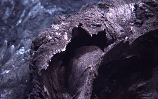 Young curtain lava flow draped and folded over the landscape originated from the Puipui eruption of Maka volcano along the NE Lau Spreading Center, as photographed during a 2009 NOAA Vents Program expedition. A previous expedition documented submarine hydrothermal plumes from Maka volcano on 21 November 2008. The chemistry of water samples suggested that these fluids could be warmed by a recent (days or weeks?) eruption of lava onto the seafloor. A return visit in May 2009 showed fresh lava flows, but without gas emission.
There are no samples for Tafu-Maka in the Smithsonian's NMNH Department of Mineral Sciences Rock and Ore collection.
| Copernicus Browser | The Copernicus Browser replaced the Sentinel Hub Playground browser in 2023, to provide access to Earth observation archives from the Copernicus Data Space Ecosystem, the main distribution platform for data from the EU Copernicus missions. |
| MIROVA | Middle InfraRed Observation of Volcanic Activity (MIROVA) is a near real time volcanic hot-spot detection system based on the analysis of MODIS (Moderate Resolution Imaging Spectroradiometer) data. In particular, MIROVA uses the Middle InfraRed Radiation (MIR), measured over target volcanoes, in order to detect, locate and measure the heat radiation sourced from volcanic activity. |
| MODVOLC Thermal Alerts | Using infrared satellite Moderate Resolution Imaging Spectroradiometer (MODIS) data, scientists at the Hawai'i Institute of Geophysics and Planetology, University of Hawai'i, developed an automated system called MODVOLC to map thermal hot-spots in near real time. For each MODIS image, the algorithm automatically scans each 1 km pixel within it to check for high-temperature hot-spots. When one is found the date, time, location, and intensity are recorded. MODIS looks at every square km of the Earth every 48 hours, once during the day and once during the night, and the presence of two MODIS sensors in space allows at least four hot-spot observations every two days. Each day updated global maps are compiled to display the locations of all hot spots detected in the previous 24 hours. There is a drop-down list with volcano names which allow users to 'zoom-in' and examine the distribution of hot-spots at a variety of spatial scales. |
|
WOVOdat
Single Volcano View Temporal Evolution of Unrest Side by Side Volcanoes |
WOVOdat is a database of volcanic unrest; instrumentally and visually recorded changes in seismicity, ground deformation, gas emission, and other parameters from their normal baselines. It is sponsored by the World Organization of Volcano Observatories (WOVO) and presently hosted at the Earth Observatory of Singapore.
GVMID Data on Volcano Monitoring Infrastructure The Global Volcano Monitoring Infrastructure Database GVMID, is aimed at documenting and improving capabilities of volcano monitoring from the ground and space. GVMID should provide a snapshot and baseline view of the techniques and instrumentation that are in place at various volcanoes, which can be use by volcano observatories as reference to setup new monitoring system or improving networks at a specific volcano. These data will allow identification of what monitoring gaps exist, which can be then targeted by remote sensing infrastructure and future instrument deployments. |
| Volcanic Hazard Maps | The IAVCEI Commission on Volcanic Hazards and Risk has a Volcanic Hazard Maps database designed to serve as a resource for hazard mappers (or other interested parties) to explore how common issues in hazard map development have been addressed at different volcanoes, in different countries, for different hazards, and for different intended audiences. In addition to the comprehensive, searchable Volcanic Hazard Maps Database, this website contains information about diversity of volcanic hazard maps, illustrated using examples from the database. This site is for educational purposes related to volcanic hazard maps. Hazard maps found on this website should not be used for emergency purposes. For the most recent, official hazard map for a particular volcano, please seek out the proper institutional authorities on the matter. |
| IRIS seismic stations/networks | Incorporated Research Institutions for Seismology (IRIS) Data Services map showing the location of seismic stations from all available networks (permanent or temporary) within a radius of 0.18° (about 20 km at mid-latitudes) from the given location of Tafu-Maka. Users can customize a variety of filters and options in the left panel. Note that if there are no stations are known the map will default to show the entire world with a "No data matched request" error notice. |
| UNAVCO GPS/GNSS stations | Geodetic Data Services map from UNAVCO showing the location of GPS/GNSS stations from all available networks (permanent or temporary) within a radius of 20 km from the given location of Tafu-Maka. Users can customize the data search based on station or network names, location, and time window. Requires Adobe Flash Player. |
| DECADE Data | The DECADE portal, still in the developmental stage, serves as an example of the proposed interoperability between The Smithsonian Institution's Global Volcanism Program, the Mapping Gas Emissions (MaGa) Database, and the EarthChem Geochemical Portal. The Deep Earth Carbon Degassing (DECADE) initiative seeks to use new and established technologies to determine accurate global fluxes of volcanic CO2 to the atmosphere, but installing CO2 monitoring networks on 20 of the world's 150 most actively degassing volcanoes. The group uses related laboratory-based studies (direct gas sampling and analysis, melt inclusions) to provide new data for direct degassing of deep earth carbon to the atmosphere. |
| Large Eruptions of Tafu-Maka | Information about large Quaternary eruptions (VEI >= 4) is cataloged in the Large Magnitude Explosive Volcanic Eruptions (LaMEVE) database of the Volcano Global Risk Identification and Analysis Project (VOGRIPA). |
| EarthChem | EarthChem develops and maintains databases, software, and services that support the preservation, discovery, access and analysis of geochemical data, and facilitate their integration with the broad array of other available earth science parameters. EarthChem is operated by a joint team of disciplinary scientists, data scientists, data managers and information technology developers who are part of the NSF-funded data facility Integrated Earth Data Applications (IEDA). IEDA is a collaborative effort of EarthChem and the Marine Geoscience Data System (MGDS). |

