According to news articles, sulfur gas poisoning from one of Salak's fume-filled craters was suspected in the deaths of six teenagers on 7 July. Several more poisoned students were taken to a nearby hospital for treatment. The students were part of a group camping on the volcano for the weekend.
Sources: Reuters, Deutsche Presse-Agentur
Six gas-related fatalities during July 2007
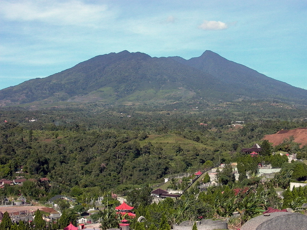
The last eruption at Salak, a stratovolcano near the W end of Java (figure 1), was in 1938, and the volcano remains in repose. According to news articles, sulfur-gas poisoning from a fume-filled crater was suspected in the deaths of six teenagers on 7 July 2007. The victims, who were between the ages of 14 and 16, were part of a group of about 50 students camping on the volcano for the weekend. Several more poisoned students were taken to a nearby hospital for treatment.
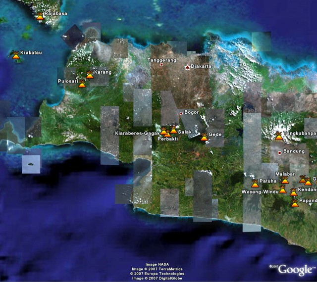 |
Figure 1. Satellite imagery from Google Earth showing Salak (center, ~60 km SSW of Jakarta) and other volcanoes of western Java. Courtesy of Google Earth. |
Information Contacts: Reuters (URL: http://www.reuters.com/); Asia-Pacific News (URL: http://www.asiapacificnews.com/); Associated Press (URL: http://www.ap.org/); Deutsche-Presse Agentur (URL: http://www.dpa.de/).
2007: July
According to news articles, sulfur gas poisoning from one of Salak's fume-filled craters was suspected in the deaths of six teenagers on 7 July. Several more poisoned students were taken to a nearby hospital for treatment. The students were part of a group camping on the volcano for the weekend.
Sources: Reuters; Deutsche Presse-Agentur
Reports are organized chronologically and indexed below by Month/Year (Publication Volume:Number), and include a one-line summary. Click on the index link or scroll down to read the reports.
Six gas-related fatalities during July 2007
The last eruption at Salak, a stratovolcano near the W end of Java (figure 1), was in 1938, and the volcano remains in repose. According to news articles, sulfur-gas poisoning from a fume-filled crater was suspected in the deaths of six teenagers on 7 July 2007. The victims, who were between the ages of 14 and 16, were part of a group of about 50 students camping on the volcano for the weekend. Several more poisoned students were taken to a nearby hospital for treatment.
|
Figure 1. Satellite imagery from Google Earth showing Salak (center, ~60 km SSW of Jakarta) and other volcanoes of western Java. Courtesy of Google Earth. |
Information Contacts: Reuters (URL: http://www.reuters.com/); Asia-Pacific News (URL: http://www.asiapacificnews.com/); Associated Press (URL: http://www.ap.org/); Deutsche-Presse Agentur (URL: http://www.dpa.de/).
|
|
||||||||||||||||||||||||||
There is data available for 5 confirmed eruptive periods.
1938 Jan 31 ± 5 days Confirmed Eruption (Explosive / Effusive) VEI: 2
| Episode 1 | Eruption (Explosive / Effusive) | Kawah Cikaluwung Putri | |||||||||||||||||||||||
|---|---|---|---|---|---|---|---|---|---|---|---|---|---|---|---|---|---|---|---|---|---|---|---|---|
| 1938 Jan 31 ± 5 days - Unknown | Evidence from Observations: Reported | |||||||||||||||||||||||
|
List of 3 Events for Episode 1 at Kawah Cikaluwung Putri
|
||||||||||||||||||||||||
1935 Feb Confirmed Eruption (Explosive / Effusive) VEI: 2
| Episode 1 | Eruption (Explosive / Effusive) | Kawah Cikaluwung Putri | ||||||||||||||||||
|---|---|---|---|---|---|---|---|---|---|---|---|---|---|---|---|---|---|---|---|
| 1935 Feb - Unknown | Evidence from Observations: Reported | ||||||||||||||||||
|
List of 2 Events for Episode 1 at Kawah Cikaluwung Putri
|
|||||||||||||||||||
1919 Confirmed Eruption (Explosive / Effusive) VEI: 2
| Episode 1 | Eruption (Explosive / Effusive) | Kawah Ratu | ||||||||||||||||||
|---|---|---|---|---|---|---|---|---|---|---|---|---|---|---|---|---|---|---|---|
| 1919 - Unknown | Evidence from Observations: Reported | ||||||||||||||||||
|
List of 2 Events for Episode 1 at Kawah Ratu
|
|||||||||||||||||||
1902 - 1903 Confirmed Eruption (Explosive / Effusive) VEI: 2
| Episode 1 | Eruption (Explosive / Effusive) | Kawah Ratu | ||||||||||||||||||
|---|---|---|---|---|---|---|---|---|---|---|---|---|---|---|---|---|---|---|---|
| 1902 - 1903 | Evidence from Observations: Reported | ||||||||||||||||||
|
List of 2 Events for Episode 1 at Kawah Ratu
|
|||||||||||||||||||
1780 Confirmed Eruption (Explosive / Effusive) VEI: 2
| Episode 1 | Eruption (Explosive / Effusive) | Kawah Ratu | ||||||||||||||||||
|---|---|---|---|---|---|---|---|---|---|---|---|---|---|---|---|---|---|---|---|
| 1780 - Unknown | Evidence from Observations: Reported | ||||||||||||||||||
|
List of 2 Events for Episode 1 at Kawah Ratu
|
|||||||||||||||||||
[ 1699 Jan 5 ] Uncertain Eruption
| Episode 1 | Eruption (Explosive / Effusive) | Salak 3 | ||||||||||||||||||||||||||||
|---|---|---|---|---|---|---|---|---|---|---|---|---|---|---|---|---|---|---|---|---|---|---|---|---|---|---|---|---|---|
| 1699 Jan 5 - Unknown | Evidence from Unknown | ||||||||||||||||||||||||||||
|
List of 4 Events for Episode 1 at Salak 3
|
|||||||||||||||||||||||||||||
This compilation of synonyms and subsidiary features may not be comprehensive. Features are organized into four major categories: Cones, Craters, Domes, and Thermal Features. Synonyms of features appear indented below the primary name. In some cases additional feature type, elevation, or location details are provided.
Synonyms |
||||
| Satak | ||||
Craters |
||||
| Feature Name | Feature Type | Elevation | Latitude | Longitude |
| Cangkuang
Tjiangkuang |
Crater | |||
Thermal |
||||
| Feature Name | Feature Type | Elevation | Latitude | Longitude |
| Cibodas, Kawah
Tjibodas, Kawah |
Thermal | |||
| Cigamea, Kawah
Tjigamea, Kawah |
Thermal | |||
| Cihideung, Cipanas
Tjihideung, Tjipanas |
Thermal | |||
| Cikaluwung Putri, Kawah
Tjikaluwung Putri, Kawah |
Thermal | |||
| Cipanas, Kawah
Tjipanas, Kawah |
Thermal | |||
| Cisalada, Cipanas
Tjisalada, Tjipanas |
Thermal | |||
| Cisalada, Kawah
Tjisalada, Kawah |
Thermal | |||
| Hirup, Kawah | Thermal | |||
| Idup, Kawah | Thermal | |||
| Paeh, Kawah | Thermal | |||
| Ratu, Kawah | Thermal | |||
| Susah, Kawah | Thermal | |||
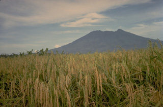 The eroded Gunung Salak volcano lies at the NE end of a dissected volcanic range in western Java. Historical eruptions have been restricted to craters in solfataric areas on Its western flank.
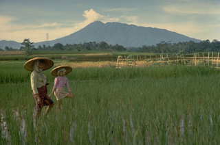 Salak is a strongly eroded volcano in western Java with flank cones on the SW flank and northern foot. Its summit crater is dormant and historical eruptions have been restricted to phreatic explosions from craters in a solfataric area at 1400 m on the western flank.
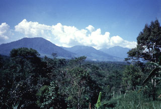 The deeply eroded Gunung Perbakti (center) rises above forests to its N, flanked by Gunung Endut (left) and Gunung Salak (right) volcanoes. Perbakti and Endut are part of the Perbatkti-Gagak volcanic complex. The summit ridge of Perbakti is elongated in a NW-SE direction, and Endut volcano rises to the SW of Perbakti. Phreatic explosions have occurred during historical time at the Perbakti-Gagak complex as well as geothermal activity.
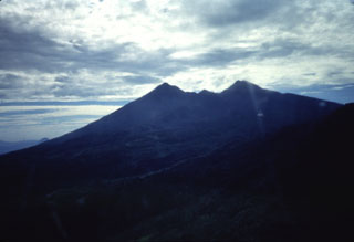 An aerial view from the west shows the profile eroded Salak volcano. Two craters trending SW and NE truncate the summit of the volcano.
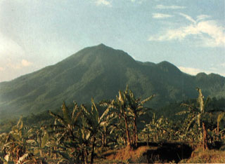 Gunung Salak is seen here from a village on the NE flank. Smaller cones are on the SW flank and at the northern foot of the forested, extensively eroded volcano. Two large breached craters are at the summit. Historical eruptions from have consisted of phreatic explosions from craters on the western flank. Salak volcano has been the site of extensive geothermal exploration.
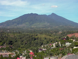 Two large breached craters truncate the summit of Gunung Salak. Historical eruptions from have consisted of phreatic explosions from craters on the western flank. Salak volcano has been the site of extensive geothermal exploration.
The following 1 samples associated with this volcano can be found in the Smithsonian's NMNH Department of Mineral Sciences collections, and may be availble for research (contact the Rock and Ore Collections Manager). Catalog number links will open a window with more information.
| Catalog Number | Sample Description | Lava Source | Collection Date |
|---|---|---|---|
| NMNH 86577 | Rhyolite | -- | -- |
| Copernicus Browser | The Copernicus Browser replaced the Sentinel Hub Playground browser in 2023, to provide access to Earth observation archives from the Copernicus Data Space Ecosystem, the main distribution platform for data from the EU Copernicus missions. |
| MIROVA | Middle InfraRed Observation of Volcanic Activity (MIROVA) is a near real time volcanic hot-spot detection system based on the analysis of MODIS (Moderate Resolution Imaging Spectroradiometer) data. In particular, MIROVA uses the Middle InfraRed Radiation (MIR), measured over target volcanoes, in order to detect, locate and measure the heat radiation sourced from volcanic activity. |
| MODVOLC Thermal Alerts | Using infrared satellite Moderate Resolution Imaging Spectroradiometer (MODIS) data, scientists at the Hawai'i Institute of Geophysics and Planetology, University of Hawai'i, developed an automated system called MODVOLC to map thermal hot-spots in near real time. For each MODIS image, the algorithm automatically scans each 1 km pixel within it to check for high-temperature hot-spots. When one is found the date, time, location, and intensity are recorded. MODIS looks at every square km of the Earth every 48 hours, once during the day and once during the night, and the presence of two MODIS sensors in space allows at least four hot-spot observations every two days. Each day updated global maps are compiled to display the locations of all hot spots detected in the previous 24 hours. There is a drop-down list with volcano names which allow users to 'zoom-in' and examine the distribution of hot-spots at a variety of spatial scales. |
|
WOVOdat
Single Volcano View Temporal Evolution of Unrest Side by Side Volcanoes |
WOVOdat is a database of volcanic unrest; instrumentally and visually recorded changes in seismicity, ground deformation, gas emission, and other parameters from their normal baselines. It is sponsored by the World Organization of Volcano Observatories (WOVO) and presently hosted at the Earth Observatory of Singapore.
GVMID Data on Volcano Monitoring Infrastructure The Global Volcano Monitoring Infrastructure Database GVMID, is aimed at documenting and improving capabilities of volcano monitoring from the ground and space. GVMID should provide a snapshot and baseline view of the techniques and instrumentation that are in place at various volcanoes, which can be use by volcano observatories as reference to setup new monitoring system or improving networks at a specific volcano. These data will allow identification of what monitoring gaps exist, which can be then targeted by remote sensing infrastructure and future instrument deployments. |
| Volcanic Hazard Maps | The IAVCEI Commission on Volcanic Hazards and Risk has a Volcanic Hazard Maps database designed to serve as a resource for hazard mappers (or other interested parties) to explore how common issues in hazard map development have been addressed at different volcanoes, in different countries, for different hazards, and for different intended audiences. In addition to the comprehensive, searchable Volcanic Hazard Maps Database, this website contains information about diversity of volcanic hazard maps, illustrated using examples from the database. This site is for educational purposes related to volcanic hazard maps. Hazard maps found on this website should not be used for emergency purposes. For the most recent, official hazard map for a particular volcano, please seek out the proper institutional authorities on the matter. |
| IRIS seismic stations/networks | Incorporated Research Institutions for Seismology (IRIS) Data Services map showing the location of seismic stations from all available networks (permanent or temporary) within a radius of 0.18° (about 20 km at mid-latitudes) from the given location of Salak. Users can customize a variety of filters and options in the left panel. Note that if there are no stations are known the map will default to show the entire world with a "No data matched request" error notice. |
| UNAVCO GPS/GNSS stations | Geodetic Data Services map from UNAVCO showing the location of GPS/GNSS stations from all available networks (permanent or temporary) within a radius of 20 km from the given location of Salak. Users can customize the data search based on station or network names, location, and time window. Requires Adobe Flash Player. |
| DECADE Data | The DECADE portal, still in the developmental stage, serves as an example of the proposed interoperability between The Smithsonian Institution's Global Volcanism Program, the Mapping Gas Emissions (MaGa) Database, and the EarthChem Geochemical Portal. The Deep Earth Carbon Degassing (DECADE) initiative seeks to use new and established technologies to determine accurate global fluxes of volcanic CO2 to the atmosphere, but installing CO2 monitoring networks on 20 of the world's 150 most actively degassing volcanoes. The group uses related laboratory-based studies (direct gas sampling and analysis, melt inclusions) to provide new data for direct degassing of deep earth carbon to the atmosphere. |
| Large Eruptions of Salak | Information about large Quaternary eruptions (VEI >= 4) is cataloged in the Large Magnitude Explosive Volcanic Eruptions (LaMEVE) database of the Volcano Global Risk Identification and Analysis Project (VOGRIPA). |
| EarthChem | EarthChem develops and maintains databases, software, and services that support the preservation, discovery, access and analysis of geochemical data, and facilitate their integration with the broad array of other available earth science parameters. EarthChem is operated by a joint team of disciplinary scientists, data scientists, data managers and information technology developers who are part of the NSF-funded data facility Integrated Earth Data Applications (IEDA). IEDA is a collaborative effort of EarthChem and the Marine Geoscience Data System (MGDS). |

