Small phreatic explosion
A small phreatic explosion took place on 29 July from one of the pools of hot water in the Naglagbong thermal area, Tiwi geothermal field, at the E foot of Malinao. The explosion ejected hot mud and blocks up to 2/3 m in diameter. The ejecta reached heights of 150 m and fell as much as 350 m from the vent. One person received second-degree burns and two buildings were damaged, one a COMVOL seismic station.
Before the explosion the pool was 15 m in diameter and 4.3 m deep, with clear emerald-green water at a temperature of 85°C. As early as 6 July, the seismograph recorded unusual microseisms. Two hours before the explosion, geysering of muddy water was observed.
[The minor explosion from the Naglabong thermal area that ejected blocks in 1980 was probably due to water drawdown during development of the Tiwi geothermal field (Newhall, 1994, pers. comm.).]
Information Contacts: O. Peña, COMVOL, Quezon City.
The Global Volcanism Program has no Weekly Reports available for Malinao.
Reports are organized chronologically and indexed below by Month/Year (Publication Volume:Number), and include a one-line summary. Click on the index link or scroll down to read the reports.
Reports of tremors and rumblings
Card 0919 (27 April 1970) Reports of tremors and rumblings
Father Hennessey reports by cable that there is a 'report (that) Mount Malinao, an extinct volcano 20 km NNW of Mayon, is becoming active.' Earth tremors 'ranging from Intensity 1 to 5' have occurred and 'deep rumblings' have been heard.
W. Ward cabled the following: 'Mount Malinao acting up, no eruption since prehistoric times.'
Malinao is located in southeastern Luzon. It is a stratovolcano with crescentic center of which the northern wall is failing. The inner crater walls are bare. There are two hot wells, Jigabo and Naglabong. At the latter well, the fumaroles had a highest temperature of 108°C in 1903.
Information Contacts: Rev. J.J. Hennessey, Manila Observatory, Manila, Philippines; W.T.T. Ward, U.S. 13th Air Force Historical Office, Clark Air Force Base, Manila, Philippines.
Small phreatic explosion
A small phreatic explosion took place on 29 July from one of the pools of hot water in the Naglagbong thermal area, Tiwi geothermal field, at the E foot of Malinao. The explosion ejected hot mud and blocks up to 2/3 m in diameter. The ejecta reached heights of 150 m and fell as much as 350 m from the vent. One person received second-degree burns and two buildings were damaged, one a COMVOL seismic station.
Before the explosion the pool was 15 m in diameter and 4.3 m deep, with clear emerald-green water at a temperature of 85°C. As early as 6 July, the seismograph recorded unusual microseisms. Two hours before the explosion, geysering of muddy water was observed.
[The minor explosion from the Naglabong thermal area that ejected blocks in 1980 was probably due to water drawdown during development of the Tiwi geothermal field (Newhall, 1994, pers. comm.).]
Information Contacts: O. Peña, COMVOL, Quezon City.
|
|
||||||||||||||||||
The Global Volcanism Program is not aware of any Holocene eruptions from Malinao. If this volcano has had large eruptions (VEI >= 4) prior to 12,000 years ago, information might be found on the Malinao page in the LaMEVE (Large Magnitude Explosive Volcanic Eruptions) database, a part of the Volcano Global Risk Identification and Analysis Project (VOGRIPA).
This compilation of synonyms and subsidiary features may not be comprehensive. Features are organized into four major categories: Cones, Craters, Domes, and Thermal Features. Synonyms of features appear indented below the primary name. In some cases additional feature type, elevation, or location details are provided.
Synonyms |
||||
| Buhi | Takit | ||||
Thermal |
||||
| Feature Name | Feature Type | Elevation | Latitude | Longitude |
| Jigabo | Thermal | |||
| Naglagbong
Naglegbeng |
Thermal | |||
| Tiwi | Thermal | 13° 28' 0.00" N | 123° 39' 0.00" E | |
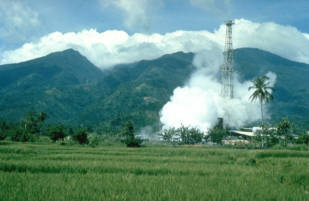
 Malinao is forested with a summit crater that opens towards the east. The Tiwi geothermal field, seen here with the volcano in the background, is located on the E flank. The geothermal field is located near Luzon's largest fumarole field, which includes siliceous sinter deposits at Naglabong.
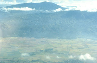 Malinao is seen here in the background of this aerial view looking to the NE with the small town of Polangui in the foreground. It contains a summit crater that opens towards the N. The ridge in the center of the photo is the W flank of Masaraga volcano.
There are no samples for Malinao in the Smithsonian's NMNH Department of Mineral Sciences Rock and Ore collection.
| Copernicus Browser | The Copernicus Browser replaced the Sentinel Hub Playground browser in 2023, to provide access to Earth observation archives from the Copernicus Data Space Ecosystem, the main distribution platform for data from the EU Copernicus missions. |
|
WOVOdat
Single Volcano View Temporal Evolution of Unrest Side by Side Volcanoes |
WOVOdat is a database of volcanic unrest; instrumentally and visually recorded changes in seismicity, ground deformation, gas emission, and other parameters from their normal baselines. It is sponsored by the World Organization of Volcano Observatories (WOVO) and presently hosted at the Earth Observatory of Singapore.
GVMID Data on Volcano Monitoring Infrastructure The Global Volcano Monitoring Infrastructure Database GVMID, is aimed at documenting and improving capabilities of volcano monitoring from the ground and space. GVMID should provide a snapshot and baseline view of the techniques and instrumentation that are in place at various volcanoes, which can be use by volcano observatories as reference to setup new monitoring system or improving networks at a specific volcano. These data will allow identification of what monitoring gaps exist, which can be then targeted by remote sensing infrastructure and future instrument deployments. |
| IRIS seismic stations/networks | Incorporated Research Institutions for Seismology (IRIS) Data Services map showing the location of seismic stations from all available networks (permanent or temporary) within a radius of 0.18° (about 20 km at mid-latitudes) from the given location of Malinao. Users can customize a variety of filters and options in the left panel. Note that if there are no stations are known the map will default to show the entire world with a "No data matched request" error notice. |
| UNAVCO GPS/GNSS stations | Geodetic Data Services map from UNAVCO showing the location of GPS/GNSS stations from all available networks (permanent or temporary) within a radius of 20 km from the given location of Malinao. Users can customize the data search based on station or network names, location, and time window. Requires Adobe Flash Player. |
| Large Eruptions of Malinao | Information about large Quaternary eruptions (VEI >= 4) is cataloged in the Large Magnitude Explosive Volcanic Eruptions (LaMEVE) database of the Volcano Global Risk Identification and Analysis Project (VOGRIPA). |
| EarthChem | EarthChem develops and maintains databases, software, and services that support the preservation, discovery, access and analysis of geochemical data, and facilitate their integration with the broad array of other available earth science parameters. EarthChem is operated by a joint team of disciplinary scientists, data scientists, data managers and information technology developers who are part of the NSF-funded data facility Integrated Earth Data Applications (IEDA). IEDA is a collaborative effort of EarthChem and the Marine Geoscience Data System (MGDS). |

