Philippines Volcanoes
Philippines has 23 Holocene volcanoes. Note that as a scientific organization we provide these listings for informational purposes only, with no international legal or policy implications. Volcanoes will be included on this list if they are within the boundaries of a country, on a shared boundary or area, in a remote territory, or within a maritime Exclusive Economic Zone. Bolded volcanoes have erupted within the past 20 years. Suggestions and data updates are always welcome ().
| Volcano Name | Last Eruption | Volcanic Region | Primary Landform |
|---|---|---|---|
| Babuyan Claro | 1924 CE | Luzon Volcanic Arc | Composite |
| Banahaw | Unknown - Evidence Credible | Luzon Volcanic Arc | Composite |
| Biliran | 1939 CE | Eastern Philippine Volcanic Arc | Composite |
| Bulusan | 2025 CE | Eastern Philippine Volcanic Arc | Composite |
| Cabalían | 1820 CE | Eastern Philippine Volcanic Arc | Composite |
| Cagua | 1860 CE | Luzon Volcanic Arc | Composite |
| Camiguin | 1953 CE | Mindanao Volcanic Province | Composite |
| Camiguin de Babuyanes | 1857 CE | Luzon Volcanic Arc | Composite |
| Didicas | 1978 CE | Luzon Volcanic Arc | Composite |
| Iraya | 1454 CE | Luzon Volcanic Arc | Composite |
| Iriga | Unknown - Evidence Credible | Eastern Philippine Volcanic Arc | Composite |
| Isarog | 3500 BCE | Eastern Philippine Volcanic Arc | Composite |
| Kanlaon | 2025 CE | Negros-Sulu Volcanic Arc | Composite |
| Leonard Range | 80 CE | Eastern Philippine Volcanic Arc | Cluster |
| Makaturing | 1882 CE | Mindanao Volcanic Province | Composite |
| Matutum | 1290 CE | Mindanao Volcanic Province | Composite |
| Mayon | 2024 CE | Eastern Philippine Volcanic Arc | Composite |
| Melebingoy | 1641 CE | Mindanao Volcanic Province | Composite |
| Musuan | Unknown - Evidence Uncertain | Mindanao Volcanic Province | Minor (Silicic) |
| Pinatubo | 2021 CE | Luzon Volcanic Arc | Composite |
| Ragang | 1916 CE | Mindanao Volcanic Province | Composite |
| San Pablo Volcanic Field | 1350 CE | Luzon Volcanic Arc | Cluster |
| Taal | 2025 CE | Luzon Volcanic Arc | Caldera |
Chronological listing of known Holocene eruptions (confirmed or uncertain) from volcanoes in Philippines. Bolded eruptions indicate continuing activity.
| Volcano Name | Start Date | Stop Date | Certainty | VEI | Evidence |
|---|---|---|---|---|---|
| Mayon | [2025 Nov 24] | [2025 Nov 28] | Uncertain | ||
| Bulusan | 2025 Apr 28 | 2025 Apr 29 | Confirmed | Observations: Reported | |
| Kanlaon | 2024 Oct 19 | 2025 Dec 17 (continuing) | Confirmed | 2 | Observations: Reported |
| Kanlaon | 2024 Jun 3 | 2024 Jun 3 | Confirmed | 3 | Observations: Reported |
| Mayon | 2024 May 30 | 2024 Jul 18 | Confirmed | 1 | Observations: Reported |
| Taal | 2024 Apr 12 | 2025 Dec 17 (continuing) | Confirmed | 2 | Observations: Reported |
| Mayon | 2023 Apr 27 ± 2 days | 2024 Feb 4 | Confirmed | 2 | Observations: Reported |
| Taal | 2022 Oct 5 | 2022 Oct 29 | Confirmed | 1 | Observations: Reported |
| Mayon | 2022 Jun 6 | 2022 Oct 7 | Confirmed | 0 | Observations: Reported |
| Bulusan | 2022 Jun 5 | 2022 Jun 12 | Confirmed | 2 | Observations: Reported |
| Pinatubo | 2021 Nov 30 | 2021 Nov 30 | Confirmed | 1 | Observations: Reported |
| Taal | 2021 Nov 15 | 2022 Apr 1 | Confirmed | 2 | Observations: Reported |
| Taal | 2021 Jul 1 | 2021 Jul 9 | Confirmed | 1 | Observations: Reported |
| Taal | 2020 Jan 12 | 2020 Jan 22 | Confirmed | 4 | Observations: Reported |
| Mayon | 2018 Jan 13 | 2019 Jul 31 ± 30 days | Confirmed | 3 | Observations: Reported |
| Kanlaon | 2017 Dec 9 | 2017 Dec 9 | Confirmed | 2 | Observations: Reported |
| Bulusan | 2017 Jun 5 | 2017 Jun 5 | Confirmed | 1 | Observations: Reported |
| Bulusan | 2016 Jun 10 | 2016 Dec 29 | Confirmed | 2 | Observations: Reported |
| Bulusan | 2016 Feb 22 | 2016 Feb 22 | Confirmed | 2 | Observations: Reported |
| Kanlaon | 2015 Nov 24 | 2016 Jun 18 | Confirmed | 2 | Observations: Reported |
| Bulusan | 2015 May 1 | 2015 Jul 17 | Confirmed | 2 | Observations: Reported |
| Mayon | 2014 Aug 12 | 2014 Oct 19 | Confirmed | 0 | Observations: Reported |
| Mayon | 2013 May 7 | 2013 May 7 | Confirmed | 1 | Observations: Reported |
| Bulusan | 2010 Nov 6 | 2011 May 13 | Confirmed | 2 | Observations: Reported |
| Mayon | 2009 Sep 15 | 2010 Jan 1 (?) | Confirmed | 2 | Observations: Reported |
| Mayon | 2008 Aug 10 | 2008 Aug 10 | Confirmed | 1 | Observations: Reported |
| Bulusan | 2006 Oct 10 | 2007 Oct 4 | Confirmed | 2 | Observations: Reported |
| Mayon | 2006 Jul 13 | 2006 Oct 1 | Confirmed | 1 | Observations: Reported |
| Kanlaon | 2006 Jun 3 | 2006 Jul 25 | Confirmed | 2 | Observations: Reported |
| Bulusan | 2006 Mar 21 | 2006 Jun 28 | Confirmed | 2 | Observations: Reported |
| Mayon | 2006 Feb 21 | 2006 Feb 23 | Confirmed | 1 | Observations: Reported |
| Mayon | 2005 Aug 17 (on or before) | Unknown | Confirmed | 0 | Observations: Reported |
| Kanlaon | 2005 Jan 25 | 2005 May 25 | Confirmed | 2 | Observations: Reported |
| Mayon | 2004 Jun 3 | 2004 Sep 12 (?) | Confirmed | 1 | Observations: Reported |
| Mayon | [2003 Oct 8] | [2003 Oct 11 (?)] | Uncertain | ||
| Mayon | 2003 Mar 17 | 2003 May 14 | Confirmed | 2 | Observations: Reported |
| Kanlaon | 2003 Mar 7 | 2003 Jul 23 | Confirmed | 1 | Observations: Reported |
| Kanlaon | 2002 Nov 28 | 2002 Nov 28 | Confirmed | 1 | Observations: Reported |
| Mayon | 2002 Oct 11 | 2002 Oct 11 | Confirmed | 1 | Observations: Reported |
| Mayon | 2001 Jan 8 | 2001 Aug 8 | Confirmed | 3 | Observations: Reported |
| Mayon | 2000 Jul 16 | 2000 Aug 31 | Confirmed | 2 | Observations: Reported |
| Mayon | 1999 Jun 22 | 2000 Mar 19 | Confirmed | 3 | Observations: Reported |
| Kanlaon | 1996 Aug 10 | 1996 Aug 10 | Confirmed | 2 | Observations: Reported |
| Bulusan | 1994 Nov 27 | 1995 Jan 28 (on or after) | Confirmed | 2 | Observations: Reported |
| Kanlaon | 1993 Aug 25 | 1993 Sep 3 | Confirmed | 2 | Observations: Reported |
| Pinatubo | 1993 Feb 16 ± 15 days | 1993 Jul 16 (?) ± 15 days | Confirmed | 1 | Observations: Reported |
| Mayon | 1993 Feb 2 | 1993 Apr 4 | Confirmed | 2 | Observations: Reported |
| Pinatubo | 1992 Jul 9 (on or before) | 1992 Oct 30 | Confirmed | 1 | Observations: Reported |
| Kanlaon | 1992 Jun 10 | 1992 Jun 10 | Confirmed | 2 | Observations: Reported |
| Kanlaon | 1992 Jan 8 | 1992 Jan 8 | Confirmed | 1 | Observations: Reported |
| Pinatubo | 1991 Apr 2 | 1991 Sep 2 | Confirmed | 6 | Observations: Reported |
| Kanlaon | 1991 Feb 14 | 1991 Feb 14 | Confirmed | 2 | Observations: Reported |
| Kanlaon | 1989 Oct 25 | 1989 Dec 13 (on or after) | Confirmed | 2 | Observations: Reported |
| Kanlaon | 1988 Jun 21 | 1988 Jul 2 | Confirmed | 1 | Observations: Reported |
| Bulusan | 1988 Feb 20 | 1988 Mar 8 | Confirmed | 2 | Observations: Reported |
| Kanlaon | 1987 Mar 30 (?) | 1987 Jul 2 | Confirmed | 1 | Observations: Reported |
| Kanlaon | 1986 Jun 3 | 1986 Aug 18 | Confirmed | 2 | Observations: Reported |
| Kanlaon | 1985 Oct 5 | 1985 Dec 7 | Confirmed | 1 | Observations: Reported |
| Kanlaon | 1985 Mar 13 | 1985 Mar 14 | Confirmed | 1 | Observations: Reported |
| Mayon | 1984 Sep 9 | 1984 Oct 6 | Confirmed | 3 | Observations: Reported |
| Bulusan | 1983 Jun 25 | 1983 Jun 29 | Confirmed | 2 | Observations: Reported |
| Bulusan | 1981 Apr 9 | 1981 Apr 27 | Confirmed | 3 | Observations: Reported |
| Kanlaon | 1980 Aug 8 | Unknown | Confirmed | 2 | Observations: Reported |
| Bulusan | 1979 Dec 27 | 1980 Sep 28 | Confirmed | 3 | Observations: Reported |
| Bulusan | 1978 Jul 29 | 1978 Aug 14 | Confirmed | 2 | Observations: Reported |
| Kanlaon | 1978 Jun 27 | 1978 Sep 2 | Confirmed | 2 | Observations: Reported |
| Mayon | 1978 Mar 7 | 1978 Sep 16 (?) ± 15 days | Confirmed | 2 | Observations: Reported |
| Didicas | 1978 Jan 6 | 1978 Jan 9 | Confirmed | 2 | Observations: Reported |
| Taal | 1977 Oct 3 | 1977 Nov 12 (?) | Confirmed | 2 | Observations: Reported |
| Taal | 1976 Sep 3 | 1976 Oct 17 | Confirmed | 2 | Observations: Reported |
| Taal | 1970 Nov 9 | 1970 Nov 13 | Confirmed | 1 | Observations: Reported |
| Kanlaon | 1970 Jun 5 | 1970 Aug 24 | Confirmed | 1 | Observations: Reported |
| Taal | 1969 Oct 29 | 1969 Dec 10 | Confirmed | 2 | Observations: Reported |
| Kanlaon | 1969 Oct 10 | 1969 Oct 29 | Confirmed | 2 | Observations: Reported |
| Didicas | 1969 Mar 21 | 1969 Jun 16 ± 15 days | Confirmed | 2 | Observations: Reported |
| Mayon | 1968 Apr 21 | 1968 May 20 | Confirmed | 3 | Observations: Reported |
| Taal | 1968 Jan 31 | 1968 Apr 2 | Confirmed | 2 | Observations: Reported |
| Taal | 1967 Aug 16 | 1967 Aug 19 | Confirmed | 1 | Observations: Reported |
| Taal | 1966 Jul 5 | 1966 Aug 4 | Confirmed | 3 | Observations: Reported |
| Taal | 1965 Sep 28 | 1965 Sep 30 | Confirmed | 4 | Observations: Reported |
| Didicas | 1952 Mar 16 (on or before) | 1953 Jul 2 (?) ± 182 days | Confirmed | 2 | Observations: Reported |
| Camiguin | 1948 Sep 1 | 1953 Jul 16 ± 15 days | Confirmed | 3 | Observations: Reported |
| Mayon | 1947 Jan 8 | 1947 Feb | Confirmed | 2 | Observations: Reported |
| Mayon | 1943 | Unknown | Confirmed | 1 | Observations: Reported |
| Mayon | 1941 Sep 13 | Unknown | Confirmed | 1 | Observations: Reported |
| Biliran | 1939 Sep 26 | Unknown | Confirmed | 1 | Observations: Reported |
| Mayon | 1939 Aug 21 | Unknown | Confirmed | 1 | Observations: Reported |
| Mayon | 1938 Jun 5 | Unknown | Confirmed | 2 | Observations: Reported |
| Bulusan | 1933 Dec 25 | Unknown | Confirmed | 2 | Observations: Reported |
| Kanlaon | 1932 Dec | 1933 Jan | Confirmed | 2 | Observations: Reported |
| Bulusan | 1928 Jun | Unknown | Confirmed | 2 | Observations: Reported |
| Mayon | 1928 Jan (?) | 1928 Aug 26 ± 5 days | Confirmed | 3 | Observations: Reported |
| Kanlaon | 1927 Mar 20 | Unknown | Confirmed | 2 | Observations: Reported |
| Babuyan Claro | 1924 | Unknown | Confirmed | 2 | Observations: Reported |
| Babuyan Claro | 1919 May | Unknown | Confirmed | 2 | Observations: Reported |
| Bulusan | 1918 Oct | 1922 May | Confirmed | 2 | Observations: Reported |
| Babuyan Claro | 1918 May 17 | 1918 May 19 | Confirmed | 2 | Observations: Reported |
| Babuyan Claro | 1917 | Unknown | Confirmed | 2 | Observations: Reported |
| Ragang | 1916 Jul 16 ± 15 days | Unknown | Confirmed | Unknown | |
| Bulusan | 1916 Jan 18 | 1916 Jan 22 | Confirmed | 2 | Observations: Reported |
| Ragang | [1915] | [Unknown] | Uncertain | ||
| Babuyan Claro | [1913] | [Unknown] | Uncertain | ||
| Matutum | [1911 Mar 7] | [Unknown] | Uncertain | ||
| Taal | 1911 Jan 27 | 1911 Feb 8 | Confirmed | 3 | Observations: Reported |
| Banahaw | [1909] | [Unknown] | Uncertain | ||
| Babuyan Claro | 1907 | Unknown | Confirmed | 2 | Observations: Reported |
| Kanlaon | 1905 Nov 6 | 1906 Jan 16 (on or after) | Confirmed | 2 | Observations: Reported |
| Taal | 1904 Apr | 1904 Jul 15 ± 5 days | Confirmed | 1 | Observations: Reported |
| Kanlaon | 1904 | Unknown | Confirmed | 2 | Observations: Reported |
| Taal | 1903 Apr | Unknown | Confirmed | 2 | Observations: Reported |
| Kanlaon | 1902 Jan 31 | Unknown | Confirmed | 2 | Observations: Reported |
| Mayon | 1902 | Unknown | Confirmed | 1 | Observations: Reported |
| Mayon | 1900 Mar 1 | 1900 Mar 6 | Confirmed | 2 | Observations: Reported |
| Didicas | 1900 | Unknown | Confirmed | 0 | Observations: Reported |
| Mayon | 1897 May 23 (on or before) | 1897 Jul 23 | Confirmed | 4 | Observations: Reported |
| Mayon | 1896 Aug 31 | 1896 Sep 27 | Confirmed | 2 | Observations: Reported |
| Mayon | 1895 Jul 20 | 1895 Nov 26 | Confirmed | 2 | Observations: Reported |
| Kanlaon | 1894 May | 1894 Jun | Confirmed | 2 | Observations: Reported |
| Bulusan | 1894 | Unknown | Confirmed | 2 | Observations: Reported |
| Mayon | 1893 Oct 3 (?) | 1893 Oct 31 | Confirmed | 1 | Observations: Reported |
| Kanlaon | 1893 Jul | Unknown | Confirmed | 2 | Observations: Reported |
| Bulusan | 1892 | Unknown | Confirmed | 2 | Observations: Reported |
| Mayon | 1891 Oct 3 | 1892 Feb 29 | Confirmed | 2 | Observations: Reported |
| Mayon | 1890 Sep 10 | 1890 Sep 30 | Confirmed | 2 | Observations: Reported |
| Bulusan | 1889 | Unknown | Confirmed | Observations: Reported | |
| Mayon | 1888 Dec 15 | Unknown | Confirmed | 1 | Observations: Reported |
| Musuan | [1886 Dec 31 ± 365 days] | [Unknown] | Uncertain | ||
| Mayon | 1886 Jul 8 | 1887 Mar 10 | Confirmed | 3 | Observations: Reported |
| Bulusan | 1886 | Unknown | Confirmed | 2 | Observations: Reported |
| Mayon | 1885 Nov 21 | 1885 Dec 2 | Confirmed | 2 | Observations: Reported |
| Taal | [1885] | [Unknown] | Uncertain | ||
| Kanlaon | [1884 May] | [1884 Jun] | Uncertain | ||
| Kanlaon | [1883 Jul] | [Unknown] | Uncertain | ||
| Makaturing | 1882 | Unknown | Confirmed | Observations: Reported | |
| Mayon | 1881 Jul 6 | 1882 Aug | Confirmed | 3 | Observations: Reported |
| Taal | 1878 Nov 12 | 1878 Nov 15 | Confirmed | 2 | Observations: Reported |
| Mayon | 1876 Nov 26 | 1876 Nov 26 | Confirmed | 1 | Observations: Reported |
| Mayon | 1876 Apr | Unknown | Confirmed | 1 | Observations: Reported |
| Taal | 1874 Jul 19 | Unknown | Confirmed | 2 | Observations: Reported |
| Mayon | 1873 Jun 20 | 1873 Jul 22 | Confirmed | 2 | Observations: Reported |
| Ragang | 1873 Jan 16 | 1873 Apr | Confirmed | 2 | Observations: Reported |
| Taal | 1873 | Unknown | Confirmed | 2 | Observations: Reported |
| Mayon | 1872 Sep 5 | 1872 Sep 9 | Confirmed | 1 | Observations: Reported |
| Mayon | 1871 Dec 8 | 1872 Jan | Confirmed | 3 | Observations: Reported |
| Ragang | 1871 Dec 8 (on or before) | Unknown | Confirmed | 2 | Observations: Reported |
| Camiguin | 1871 Apr 30 | 1875 | Confirmed | 2 | Observations: Reported |
| Mayon | 1868 Dec 17 | Unknown | Confirmed | 2 | Observations: Reported |
| Kanlaon | 1866 | Unknown | Confirmed | 2 | Observations: Reported |
| Makaturing | 1865 | Unknown | Confirmed | 2 | Observations: Reported |
| Mayon | [1863 May 30] | [Unknown] | Uncertain | ||
| Camiguin | 1862 | Unknown | Confirmed | 2 | Observations: Reported |
| Mayon | 1862 | Unknown | Confirmed | 2 | Observations: Reported |
| Mayon | 1861 | Unknown | Confirmed | 1 | Observations: Reported |
| Cagua | 1860 Oct | Unknown | Confirmed | 2 | Observations: Reported |
| Babuyan Claro | 1860 | Unknown | Confirmed | 2 | Observations: Reported |
| Mayon | 1860 | Unknown | Confirmed | Observations: Reported | |
| Mayon | 1859 | Unknown | Confirmed | Observations: Reported | |
| Ragang | 1858 Feb 18 | Unknown | Confirmed | 2 | Observations: Reported |
| Mayon | 1858 Jan | 1858 Dec | Confirmed | 2 | Observations: Reported |
| Makaturing | [1858] | [Unknown] | Uncertain | ||
| Mayon | 1857 | Unknown | Confirmed | 2 | Observations: Reported |
| Camiguin de Babuyanes | 1857 (in or before) | Unknown | Confirmed | 2 | Observations: Reported |
| Ragang | 1856 Nov 1 | Unknown | Confirmed | 2 | Observations: Reported |
| Didicas | 1856 Sep 30 ± 30 days | 1860 Oct (?) | Confirmed | 2 | Observations: Reported |
| Makaturing | [1856] | [Unknown] | Uncertain | ||
| Mayon | 1855 Mar 22 | Unknown | Confirmed | 2 | Observations: Reported |
| Mayon | 1853 Jul 13 | 1853 Aug 26 | Confirmed | 3 | Observations: Reported |
| Bulusan | [1852] | [Unknown] | Uncertain | ||
| Mayon | 1851 May 26 | 1851 Jun | Confirmed | 1 | Observations: Reported |
| Mayon | 1846 May 11 | 1846 May 11 | Confirmed | 3 | Observations: Reported |
| Mayon | 1845 Jan 20 ± 1 days | 1845 Jan 30 ± 1 days | Confirmed | 3 | Observations: Reported |
| Banahaw | [1843] | [Unknown] | Uncertain | ||
| Taal | 1842 | Unknown | Confirmed | 2 | Observations: Reported |
| Ragang | 1840 Jan 20 | 1840 Apr 5 | Confirmed | 2 | Observations: Reported |
| Mayon | 1839 | Unknown | Confirmed | 2 | Observations: Reported |
| Mayon | 1834 | 1835 May | Confirmed | 3 | Observations: Reported |
| Ragang | 1834 | Unknown | Confirmed | 2 | Observations: Reported |
| Mayon | 1827 Jun 27 | 1828 Feb 28 | Confirmed | 2 | Observations: Reported |
| Camiguin | 1827 | Unknown | Confirmed | 2 | Observations: Reported |
| Taal | 1825 | Unknown | Confirmed | 2 | Observations: Reported |
| Cabalían | 1820 ± 30 years | Unknown | Confirmed | Isotopic: 14C (uncalibrated) | |
| Mayon | 1814 Feb 1 | 1814 Feb 15 (on or after) | Confirmed | 4 | Observations: Reported |
| Mayon | [1811 Oct 5] | [1811 Oct 6] | Uncertain | ||
| Taal | 1808 Feb | 1808 Apr | Confirmed | 2 | Observations: Reported |
| Mayon | 1800 Oct 30 | 1800 Oct 31 | Confirmed | 2 | Observations: Reported |
| Taal | 1790 | Unknown | Confirmed | 2 | Observations: Reported |
| Didicas | [1773 Oct] | [Unknown] | Uncertain | ||
| Mayon | 1766 Jul 20 | 1766 Jul 25 | Confirmed | 3 | Observations: Reported |
| Ragang | 1756 | Unknown | Confirmed | 2 | Observations: Reported |
| Taal | 1754 May 15 | 1754 Dec 4 | Confirmed | 4 | Observations: Reported |
| Taal | 1749 Aug 11 (?) | 1749 Sep | Confirmed | 4 | Observations: Reported |
| Banahaw | [1743 (?)] | [Unknown] | Uncertain | ||
| Taal | 1731 | Unknown | Confirmed | 2 | Observations: Reported |
| Banahaw | [1730] | [Unknown] | Uncertain | ||
| Taal | 1729 | Unknown | Confirmed | 2 | Observations: Reported |
| Taal | 1716 Sep 24 | 1716 Sep 27 | Confirmed | 4 | Observations: Reported |
| Taal | 1715 | Unknown | Confirmed | 2 | Observations: Reported |
| Taal | 1709 | Unknown | Confirmed | 2 | Observations: Reported |
| Taal | 1707 | Unknown | Confirmed | 2 | Observations: Reported |
| Babuyan Claro | 1652 | Unknown | Confirmed | 3 | Observations: Reported |
| Taal | 1645 | Unknown | Confirmed | 3 | Observations: Reported |
| Taal | 1641 | Unknown | Confirmed | 3 | Observations: Reported |
| Melebingoy | 1640 Dec 26 ± 5 days | 1641 Jan 4 | Confirmed | 5 | Observations: Reported |
| Taal | 1635 | Unknown | Confirmed | 3 | Observations: Reported |
| Taal | 1634 | Unknown | Confirmed | 3 | Observations: Reported |
| Mayon | 1616 Feb 19 | 1616 Feb 23 | Confirmed | 3 | Observations: Reported |
| Taal | 1608 ± 3 years | Unknown | Confirmed | 2 | Observations: Reported |
| Taal | 1591 | Unknown | Confirmed | 3 | Observations: Reported |
| Taal | 1572 | Unknown | Confirmed | 3 | Observations: Reported |
| Iraya | 1454 (?) | Unknown | Confirmed | Observations: Reported | |
| Pinatubo | 1450 ± 50 years | Unknown | Confirmed | 5 | Isotopic: 14C (calibrated) |
| Melebingoy | 1380 ± 75 years | Unknown | Confirmed | 4 | Isotopic: 14C (calibrated) |
| San Pablo Volcanic Field | 1350 ± 100 years | Unknown | Confirmed | Correlation: Anthropology | |
| Matutum | 1290 ± 40 years | Unknown | Confirmed | Isotopic: 14C (uncalibrated) | |
| Bulusan | 0950 (?) | Unknown | Confirmed | Isotopic: 14C (uncalibrated) | |
| Iraya | 0470 ± 50 years | Unknown | Confirmed | Isotopic: 14C (uncalibrated) | |
| Mayon | 0470 ± 75 years | Unknown | Confirmed | Isotopic: 14C (uncalibrated) | |
| Iraya | 0250 ± 200 years | Unknown | Confirmed | Isotopic: 14C (uncalibrated) | |
| Leonard Range | 0080 ± 60 years | Unknown | Confirmed | Isotopic: 14C (uncalibrated) | |
| Leonard Range | 0077 BCE ± 54 years | Unknown | Confirmed | Isotopic: 14C (uncalibrated) | |
| Matutum | 0170 BCE ± 80 years | Unknown | Confirmed | Isotopic: 14C (uncalibrated) | |
| Matutum | 0400 BCE ± 60 years | Unknown | Confirmed | Isotopic: 14C (uncalibrated) | |
| Pinatubo | 1050 BCE ± 500 years | Unknown | Confirmed | 6 | Isotopic: 14C (calibrated) |
| Melebingoy | 1920 BCE ± 40 years | Unknown | Confirmed | 4 | Isotopic: 14C (uncalibrated) |
| Mariveles | [2050 BCE (?)] | [Unknown] | Uncertain | ||
| Bulusan | 3050 BCE (?) | Unknown | Confirmed | Isotopic: 14C (uncalibrated) | |
| Mayon | 3100 BCE ± 300 years | Unknown | Confirmed | Isotopic: 14C (uncalibrated) | |
| Isarog | 3500 BCE ± 125 years | Unknown | Confirmed | Isotopic: 14C (calibrated) | |
| Pinatubo | 3550 BCE (?) | Unknown | Confirmed | 6 | Isotopic: 14C (calibrated) |
| Taal | 3580 BCE ± 200 years | Unknown | Confirmed | 6 | Isotopic: 14C (uncalibrated) |
| Leonard Range | 4092 BCE ± 122 years | Unknown | Confirmed | Isotopic: 14C (uncalibrated) | |
| Pinatubo | 7030 BCE ± 300 years | Unknown | Confirmed | Isotopic: 14C (calibrated) | |
| Pinatubo | 7460 BCE ± 150 years | Unknown | Confirmed | 6 | Isotopic: 14C (calibrated) |
Philippines has 51 Pleistocene volcanoes. Note that as a scientific organization we provide these listings for informational purposes only, with no international legal or policy implications. Volcanoes will be included on this list if they are within the boundaries of a country, on a shared boundary or area, in a remote territory, or within a maritime Exclusive Economic Zone. Suggestions and data updates are always welcome ().
| Volcano Name | Volcanic Region | Primary Landform |
|---|---|---|
| Alto | Eastern Philippine Volcanic Arc | Composite |
| Amorong Group | Luzon Volcanic Arc | Cluster |
| Ampiro | Mindanao Volcanic Province | Composite |
| Anilao Hill | Luzon Volcanic Arc | Minor |
| Apo | Mindanao Volcanic Province | Composite |
| Arayat | Luzon Volcanic Arc | Composite |
| Balatukan | Mindanao Volcanic Province | Composite |
| Balintang | Luzon Volcanic Arc | Composite |
| Balut | Mindanao Volcanic Province | Composite |
| Blit | Mindanao Volcanic Province | Unknown |
| Cancajanag | Eastern Philippine Volcanic Arc | Minor |
| Cariliao | Luzon Volcanic Arc | Composite |
| Cone-Culasi | Eastern Philippine Volcanic Arc | Cluster |
| Corregidor | Luzon Volcanic Arc | Caldera |
| Cuernos de Negros | Negros-Sulu Volcanic Arc | Composite |
| Dagit-Dagitan | Luzon Volcanic Arc | Composite |
| Diogo | Luzon Volcanic Arc | Composite |
| Gate Mountains | Eastern Philippine Volcanic Arc | Unknown |
| Hingatungan | Eastern Philippine Volcanic Arc | Composite |
| Ilihan | Eastern Philippine Volcanic Arc | Unknown |
| Imbing | Negros-Sulu Volcanic Arc | Composite |
| Jolo | Negros-Sulu Volcanic Arc | Cluster |
| Kaladis | Negros-Sulu Volcanic Arc | Composite |
| Kalatungan | Mindanao Volcanic Province | Composite |
| Kitabud | Mindanao Volcanic Province | Unknown |
| Labo | Eastern Philippine Volcanic Arc | Composite |
| Laguna Caldera | Luzon Volcanic Arc | Caldera |
| Latukan | Mindanao Volcanic Province | Composite |
| Lobi | Eastern Philippine Volcanic Arc | Composite |
| Mabudis-Siayan | Luzon Volcanic Arc | Composite |
| Mahagnao | Eastern Philippine Volcanic Arc | Composite |
| Malepunyo | Luzon Volcanic Arc | Composite |
| Malinao | Eastern Philippine Volcanic Arc | Composite |
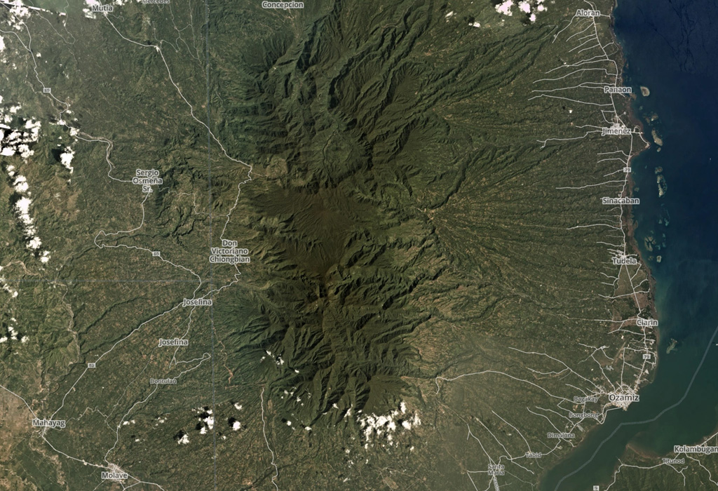
| Malindang | Mindanao Volcanic Province | Composite |
| Malindig | Luzon Volcanic Arc | Composite |
| Mandalagan | Negros-Sulu Volcanic Arc | Composite |
| Maripipi | Eastern Philippine Volcanic Arc | Unknown |
| Mariveles | Luzon Volcanic Arc | Composite |
| Masaraga | Eastern Philippine Volcanic Arc | Composite |
| Matarem | Luzon Volcanic Arc | Composite |
| Natib | Luzon Volcanic Arc | Composite |
| Nelangaapan | Eastern Philippine Volcanic Arc | Unknown |
| Pacdahauan | Eastern Philippine Volcanic Arc | Unknown |
| Paco-Maniayao | Eastern Philippine Volcanic Arc | Composite |
| Panay | Luzon Volcanic Arc | Composite |
| Pocdol Mountains | Eastern Philippine Volcanic Arc | Composite |
| Quezon | Mindanao Volcanic Province | Minor |
| Sangay | Eastern Philippine Volcanic Arc | Unknown |
| Santo Tomas | Luzon Volcanic Arc | Composite |
| Silay | Negros-Sulu Volcanic Arc | Composite |
| Y'Ami-North | Luzon Volcanic Arc | Composite |
There are 147 photos available for volcanoes in Philippines.
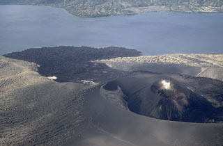 An eruption that began on 31 January 1968 produced the Mt. Tabaro scoria cone on Volcano Island in the Taal caldera. The lava flow forming the lava delta was emplaced during this eruption, which lasted until 2 April. This December 1968 aerial view from the lava flow traveled to the lake within the crater produced during the major 1965 eruption.
Photo by Kurt Frederickson, 1968 (Smithsonian Institution).
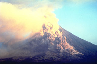
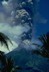
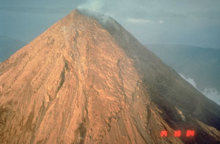
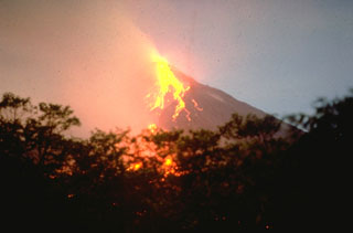 Incandescent blocks roll down the SW flanks of Mayon on 18 May 1978, seen from near Camalig on the SW flank. During the eruption a lava flow traveled a distance of more than 4 km over the top of the 1968 lava flow to about 550 m elevation. The 1978 eruption began on 7 March and continued through the summer.
Photo by Chris Newhall, 1978 (U.S. Geological Survey).
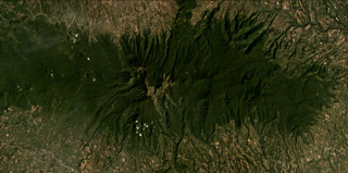 Kalatungan forms the E-W trending volcanic ridge across this November 2019 Planet Labs satellite image monthly mosaic (N is at the top; this image is approximately 25 km across). Extensive erosion has formed ridge-and-gully topography across the flanks.
Satellite image courtesy of Planet Labs Inc., 2020 (https://www.planet.com/).
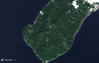 Mount Panay is a low andesitic stratovolcano occupying the elongated Calumpang Peninsula between Balayan Bay (left) and Batangas Bay (right). It is considered to be Pleistocene in age, and has current geothermal activity.
Satellite image courtesy of Copernicus Sentinel Data, 2019.
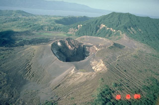
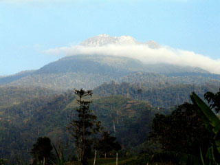
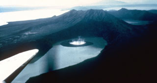
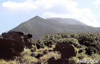
 Frequent eruptions have been recorded since the mid-19th century and have kept the summit of Bulusan volcano unvegetated. The principal summit crater is 300 m wide and 50 m deep, with two craters are located on the lower SE flank, the lower of which contains a crater lake.
Photo by Chris Newhall (U.S. Geological Survey).
 The southern wall is the most prominent segment of the 11-km-wide Irosin caldera, and overlooks the flat caldera floor below the active Bulusan volcano. The northern caldera rim has been buried by the flanks of Bulusan and other post-caldera cones.
Photo by Chris Newhall (U.S. Geological Survey).
 A gas-and-steam plume rises from the summit of Mayon volcano in this May 1968 view from Legaspi City on the SSE flank. The smaller plume on the lower left flank is from the lava flow front that descended 4 km from the summit.
Photo by Jim Moore, 1968 (U.S. Geological Survey).
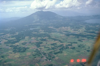
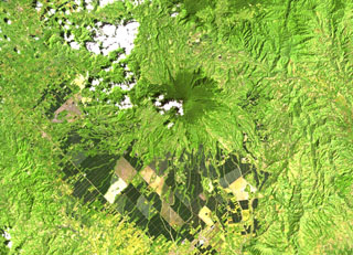 Matutum rises above farmlands in southern Mindanao. A well-preserved 320-m-wide and 120-m-deep crater has a densely forested floor. Widespread pyroclastic flow deposits surround the volcano.
 NASA Landsat image, 2000 (courtesy of Hawaii Synergy Project, Univ. of Hawaii Institute of Geophysics & Planetology).
 This 400-m-wide crater formed during an eruption of Taal in 1976. That eruption modified cones and craters that had been constructed during yearly eruptions from 1966 to 1970 within a larger crater that formed during the 1965 eruption. This 1984 photo from the SW also shows the small 1977 crater along the margin of the flat bench at the upper right side of the 1976 crater.
Photo by Chris Newhall, 1989 (U.S. Geological Survey).
 The broad light-colored areas are thick pyroclastic flow deposits from the 15 June 1991 Pinatubo eruption. This 29 June photo taken two weeks after the eruption is looking towards the east with Clark Air Base just beyond the margin of the pyroclastic flow fan. Debris flows or lahars have remobilized significant volumes of the unconsolidated pumice and ash since 1991. Mount Arayat is visible at the upper left.
Photo by Ed Wolfe, 1991 (U.S. Geological Survey).
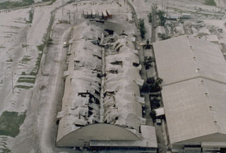 Heavy ashfall from the 15 June 1991 eruption of Pinatubo volcano caused the roof of this warehouse at Clark Air Base to collapse. The base had been evacuated prior to the major explosion on the 15th.
Photo by R. Batalon, 1991 (U.S. Air Force).
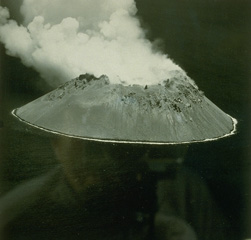 Didicas volcano forms a small, 1.4-km wide island in the Philippines, north of Luzon Island. Prior to 1952, when a lava dome formed, the volcano was submarine. A 5-acre island was first seen on March 16; this June 17 view shows the new steaming lava dome. Submarine eruptions were reported in 1773, during 1856-1860 (when an ephemeral island was formed), and around 1900.
 From the collection of Maurice and Katia Krafft.
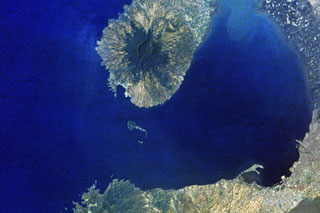
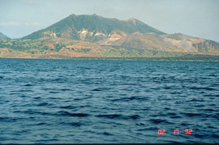
 Mt. Vulcan (left) and Hibok-Hibok (right) are two historically active lava domes on Camiguin Island. These two domes were active in the 19th and 20th centuries, with Mt. Vulcan forming in 1871. Several historical eruptions have occurred at Hibok-Hibok with the most recent during 1948-1953, when pyroclastic flows devastated island villages. The 20-km-long Camiguin Island lies just off the coast of north-central Mindanao Island and consists of four overlapping volcanoes and flank lava domes.
Photo by Juny La Putt, 2002.
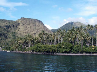
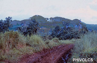
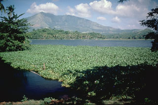
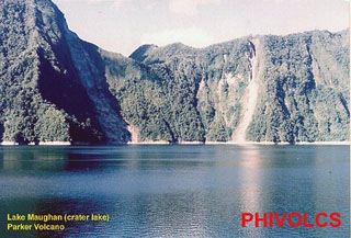 Lake Maughan occupies the steep-sided walls of the 2.9-km-wide Parker summit caldera of , also known locally as Falen. This vegetated edifice overlooks Sarangani Bay near the southern tip of Mindanao Island and is surrounded by extensive, young pyroclastic flow deposits. This volcano was the source of a major explosive eruption in 1641.
Photo courtesy of PHIVOLCS.
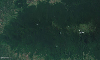
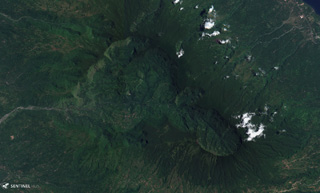
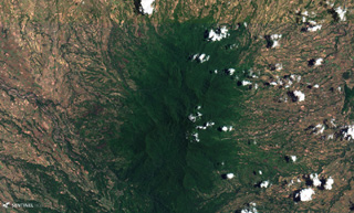
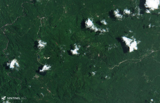 The Mahagnao volcanic complex is in the center of this 20 August 2018 Sentinel-2 satellite image (N is at the top), which is approximately 10 km across. The complex includes the Kasiboi and Danan cones and has current geothermal activity.
Satellite image courtesy of Copernicus Sentinel Data, 2018.
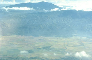
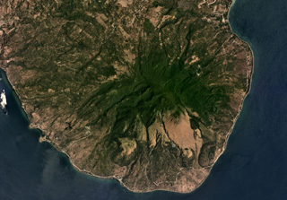
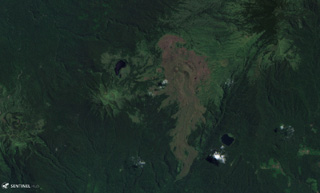
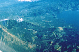 Collapses at the summit or flanks of volcanoes during major volcanic landslides can create large horseshoe-shaped craters that open in the direction of the landslide, like this 2.1 x 3.5 km crater at Iriga in the Philippines. It was produced by a massive landslide during the Holocene. The resulting debris avalanche traveled more than 10 km to the SE and flowed into Lake Buhi at the upper right. This view is from the south, with the summit to the left.
Photo by Chris Newhall (U.S. Geological Survey).
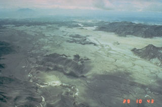
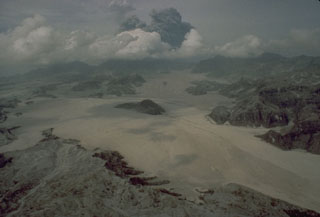
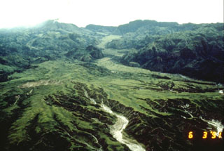
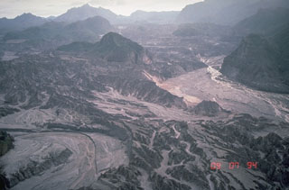 Thick pyroclastic flow deposits from the 1991 eruption of Pinatubo were rapidly eroded in the years following the eruption. This 7 September 1994 view of the upper Marella River valley from the SW, with the caldera rim on the skyline, shows the effects of the erosion of well over 100 m of pyroclastic flow deposits. Light-colored deposits in the channels at the middle right and lower left are post-1991 lahar deposits.
Photo by Chris Newhall, 1994 (U.S. Geological Survey).
 This ash-covered newsstand on Clark Air Base holds a newspaper with the headline “Mt. Pinatubo showers Clark.” Powerful eruptions of Pinatubo volcano in June 1991 forced closure of the base.
Photo by Val Gempis, 1991 (U.S. Air Force).
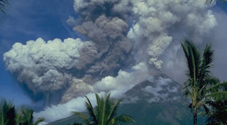
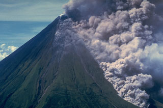 An ash plume rises above a pyroclastic flow traveling down the Buang valley on the upper NW flank of Mayon volcano in the Philippines on 12 September 1984. The front of the advancing pyroclastic flow is visible at the lower right. These pyroclastic flows traveled down to 100 m elevation at rates of about 20 m/s.
Photo by Olimpio Pena, 1984 (Philippine Institute of Volcanology and Seismology).
 An alignment of craters is visible in this 10 August 2019 Sentinel-2 satellite image (N is at the top) showing Makaturing volcano in central Mindanao. The width of this image is approximately 28 km. The summit is near the center of the image.
Satellite image courtesy of Copernicus Sentinel Data, 2019.
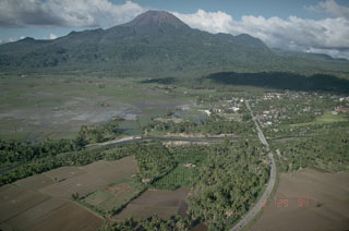
 Malinao is seen here in the background of this aerial view looking to the NE with the small town of Polangui in the foreground. It contains a summit crater that opens towards the N. The ridge in the center of the photo is the W flank of Masaraga volcano.
Photo by Chris Newhall (U.S. Geological Survey).
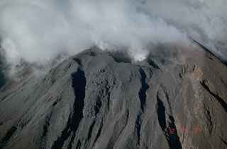
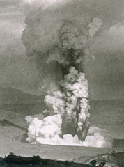
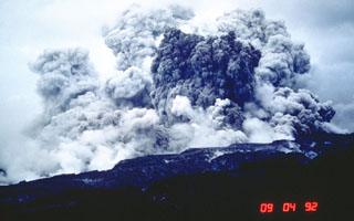 An ash plume rises several kilometers above the west flank of Pinatubo on 4 September 1992. This was not the result of an eruption, but of secondary explosions produced when water contacted still-hot pyroclastic flow deposits of the 1991 eruption. This can occur either when channel banks eroded into the deposits collapse into streams, or when groundwater invades hot deposits along buried stream channels. Ash plumes as high as 18 km were produced by these events, as well as pyroclastic flows.
Photo by Chris Newhall, 1992 (U.S. Geological Survey).
 Taal caldera, seen here from its NW rim, is a 15 x 20 km caldera of Pleistocene and Holocene age. Volcano Island, in the north-central part of Lake Taal, is constructed of coalescing small tuff and scoria cones. Powerful phreatomagmatic explosive eruptions from several locations on the 5-km-wide island have produced deadly pyroclastic surges.
Photo by Chris Newhall, 1978 (U.S. Geological Survey).
 Voluminous pyroclastic flows on 15 June 1991 descended all sides of Mount Pinatubo in the Philippines. The flat, light-colored areas in the foreground are pyroclastic flow deposits that filled the Marella River valley on Pinatubo's SW flank to a depth of 200 m. The dark hill at the center was completely surrounded by pyroclastic flows that traveled 14 km down this valley.
Photo by Rick Hoblitt, 1991 (U.S. Geological Survey).
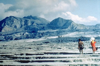 An Aeta couple returns to inspect their land along the Maraunot River on the NW flank of Pinatubo following the catastrophic eruption of 15 June 1991. At least 10,000 members of the nomadic Aeta peoples, whose native lands were on the slopes of Pinatubo, were displaced by the eruption.
Photo by Ray Punongbayan (Philippine Institute of Volcanology and Seismology).
 Malindig (or Marlanga) volcano is located in southern Marinduque island, shown in this April 2019 Planet Labs satellite image monthly mosaic (N is at the top; this image is approximately 13 km across). The irregular summit shows evidence of lava dome emplacement, possible flank collapse or landslide scarps, and extensive erosion.
Satellite image courtesy of Planet Labs Inc., 2019 (https://www.planet.com/).
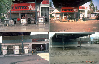 Owners of a service station in the city of Bacolor, 38 km SE of Pinatubo in the Philippines, adapted to ongoing lahars over many years; note the garage door opening at right and the height of the canopy in each photo. On 12 September 1991 (upper left), 10 days after the end of the 1991 eruption, they dug out gas pumps buried by 1-m-thick lahar deposits. By 30 November 1991 (upper right) they had raised the pumps to the new ground level. Three years later, in September 1994 (bottom left), the pumps had again been raised, to a ground surface now half the height of the original garage opening. A year later (bottom right) a 5-m-high lahar deposit filled the garage, and the station had been abandoned.
Photos by Chris Newhall, 1991-1995 (U.S. Geological Survey).
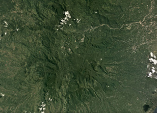
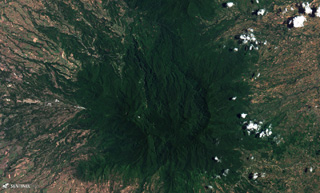
 Balatukan (also known as Balatocan) is part of the central Mindano volcanic arc in the Philippines, seen here in this 10 August 2019 Sentinel-2 satellite image (N is at the top). The edifice is deeply eroded and geothermal activity occurs in the area.
Satellite image courtesy of Copernicus Sentinel Data, 2019.
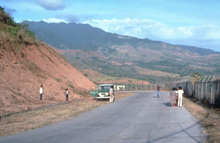
 The northernmost active volcano in Luzon is Mount Cagua at the NE tip of the island. A phreatic explosion in 1860 may have been accompanied by a pyroclastic flow. Thermal areas are located near the summit crater and on the NW to NNE flanks.
Photo courtesy of PHIVOLCS.
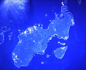
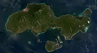
 Camiguin Island, just off the coast of north-central Mindanao Island (lower right), consists of four overlapping cones. Cloud-covered Mt. Mambajao forms the high point of the island. The youngest volcano, Hibok-Hibok (also known as Catarman) at the NW end of the island, has been historically active. Major eruptions during 1871-75 and 1948-53 formed flank lava domes at Hibok-Hibok and produced pyroclastic flows that devastated coastal villages.
NASA Landsat image, 2002 (courtesy of Hawaii Synergy Project, Univ. of Hawaii Institute of Geophysics & Planetology).
 Cuernos de Negros is a large volcano composed of multiple edifices including Mount Talines, Mount Guinsayawan, and Guintabon Dome, seen in this June 2017 Planet Labs satellite image monthly mosaic (N is at the top; this image is approximately 24 km across). The Magaso summit crater contains active fumaroles and the Palinpinon geothermal field is on a N flank.
Satellite image courtesy of Planet Labs Inc., 2017 (https://www.planet.com/).
 Mount Isarog is seen in the background to the NW beyond the lower flanks of Iriga volcano in the foreground. It occupies the broad isthmus between Lagonoy Gulf and San Miguel Bay. The summit contains a large crater with a deep and narrow notch on the lower eastern flank.
Photo by Chris Newhall (U.S. Geological Survey).
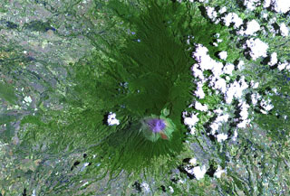 Kanlaon is the most active volcano of the central Philippines and the highest point on the island of Negros, lies at the southern end of the summit ridge and overlooks a 15 km2 caldera to the N. Five major vents are aligned NNE within the smaller active crater. Eruptions recorded since 1866 have typically consisted of small-to-moderate phreatic explosions that produce minor ashfalls near the volcano.
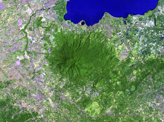
NASA Landsat image, 2003 (courtesy of Hawaii Synergy Project, Univ. of Hawaii Institute of Geophysics & Planetology).
 Apo volcano, the highest peak in the Philippines, rises SW of the coastal city of Davao. The SW peak is the highest point and contains a 500-m-wide crater with a small lake. The youngest crater is on the northern peak of the volcano, whose name means “master” or “grandfather.”
Photo by Paul Boscher, 2005.
 Silay is the northernmost volcano on Negros Island in the Philippines and is shown in this 25 April 2019 Sentinel-2 satellite image (N is at the top), which is approximately 23 km across.
Satellite image courtesy of Copernicus Sentinel Data, 2019.
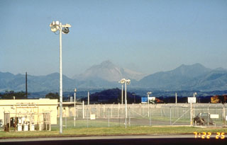 Pinatubo is seen here from Clark Air Base on the ENE the day before the catastrophic 14 June 1991 eruption that formed a caldera. The evacuation of Clark Air Base was completed on 10 June. The peak in the center is the former 1,745 m summit, which is covered with ash from activity that had begun on 2 April and intensified strongly on 12 June. The high dark ridge to the right is the NE rim of the 4 x 5 km Tayawan caldera of ancestral Pinatubo volcano.
Photo by Rick Hoblitt, 1991 (U.S. Geological Survey).
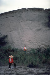
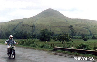 The grass-covered Musuan volcano, also known as Calayo, is an isolated lava dome and tuff cone that rises more than 600 m above flat farmland in the province of Bukidnon in central Mindanao.
Photo courtesy of PHIVOLCS.
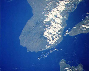
 The low-profile Mariveles volcano forms the southern end of the Bataan Peninsula, on the W side of Manila Bay, and contains a 4-km-wide caldera that opens to the N. A Holocene eruption has been radiocarbon dated at 4,000 years before present. The city of Manila at the lower right lies 50 km across the bay from the volcano.
NASA Space Shuttle image, 1992 (http://eol.jsc.nasa.gov/).
 A lava flow descends the Bonga valley on the east flank of Mayon in March 1993. The lava flow had descended 4.5 km by 26 March and partially filled the deep Bonga valley, which was excavated by pyroclastic flows during the 1984 eruption.
Photo by Philippine Institute of Volcanology and Seismology, 1993.
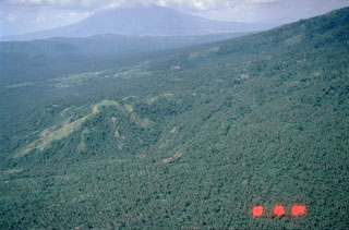
 Poorly known Latukan volcano (right of center) lies in the middle of a chain of young E-W-trending volcanoes in NW Mindanao, SE of Lake Lanao (out of view to the upper left). Latukan is flanked on the west by Makaturing volcano (left-center) and closely on the east by the historically active Ragang volcano.
 NASA Landsat image, 2003 (courtesy of Hawaii Synergy Project, Univ. of Hawaii Institute of Geophysics & Planetology).
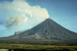
 Mayon in SE Luzon is one of the most active volcanoes in the Philippines. It rises above the Albay Gulf and is the result of eruptions from a single central conduit. Frequent eruptions have been recorded since 1616 and have typically included powerful explosive activity accompanied by pyroclastic flows, lahars, and lava flows that descended to the lower flanks.
Photo by Kurt Fredrickson, 1968 (Smithsonian Institution).
 A light-colored plume rises above the summit of Mayon volcano on 14 September 1984, seen here from Cagsawa on the SSE flank. The darker and denser column to its left is an ash plume rising from the pyroclastic flow moving down the SW flank.
Photo by Ernesto Corpuz, 1984 (Philippine Institute of Volcanology and Seismology).
 Magaso, also known as Cuernos de Negros, is a large stratovolcano that anchors the SE tip of Negros Island. The volcano is located just right of center in the cloud-covered portion of SE Negros Island in this Space Shuttle image (with north to the upper right), directly across the channel and in line with the SW tip of Cebu Island at the right side of the image. No historical eruptions are known from Magaso, but the summit crater is fumarolically active, and the Palinpinon geothermal field are located at its base.
NASA Space Shuttle image STS61-40-74, 1985 (http://eol.jsc.nasa.gov/).
 The deeply eroded Mandalagan volcanic complex on northern Negros Island is seen here in this 25 April 2019 Sentinel-2 satellite image (N is at the top). Seven volcanic centers have been identified and geothermal activity continues. This image is approximately 23 km across.
Satellite image courtesy of Copernicus Sentinel Data, 2019.
 Mount Natib is located at the northern end of the Bataan Peninsula, S of Pinatubo. The summit of the volcano, seen here from the WNW, is truncated by a 6 x 7 km caldera. The age of the latest eruption is not known, but is considered to be late Pleistocene or Holocene. Five thermal areas are found in the summit region.
Photo by Chris Newhall, 1989 (U.S. Geological Survey).
 The eroded Malindang edifice is shown in this February 2018 Planet Labs image (N is at the top), near Iligan Bay in Mindanao.
Satellite image courtesy of Planet Labs Inc., 2018 (https://www.planet.com/).
 Geologists investigate a thick pyroclastic flow deposit on the ENE side of Parker volcano in southern Mindanao. Preliminary investigation of the eruptive deposits of this volcano revealed many similarities to those of Pinatubo. The flanks of both volcanoes are blanketed with thick pyroclastic flow deposits produced by powerful explosive eruptions.
Photo courtesy of Chris Newhall (U.S. Geological Survey).
 Mount Tabaro on Volcano Island at Taal is seen here from the west in 1992. The sloping ridge extending across the photo from the lower right shoreline is the rim of the elongate 1965 vent system. The dark lava flow along the coastline was erupted in 1968 from a scoria cone that formed in the 1965 vent. This and other overlapping scoria cones and craters at the right-center formed during 1966 to 1977 eruptions.
Photo by Chris Newhall (U.S. Geological Survey).
 The dumbbell-shaped, E-W-trending Jolo island contains numerous pyroclastic cones and craters, some of which are visible in this Space Shuttle image with north to the upper left. The island is about 60 km wide in an E-W direction; its largest city, Jolo, lies on the northern coast (left-center). The isolated location of Jolo at the SW end of the Philippines archipelago as well as political unrest have inhibited geological studies of the volcano.
 NASA Space Shuttle image STS50-99-94, 1992 (http://eol.jsc.nasa.gov/).
 A small pyroclastic flow descends the Bonga valley on the E flank of Mayon in March 1993. Collapse of a lava flow front traveling down the valley produced many small pyroclastic flows during the 1993 eruption. A large pyroclastic flow on 2 February, the first day of the eruption, traveled 6 km down this same valley and killed 75 people.
Photo by Philippine Institute of Volcanology and Seismology, 1993.
 The flat, lighter-green, vegetated deposit that winds down the valley at the top center of the photo is a pyroclastic flow fan from the last major eruption of Pinatubo prior to 1991, about 500 years ago. This photo, taken on 3 June 1991, shows the pre-eruption profile of the upper Marella River valley.
 Photo by Rick Hoblitt, 1991 (U.S. Geological Survey).
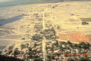 Lahars produced devastating social and economic disruption for many years after the 1991 eruption of Pinatubo in the Philippines. The towns of Barangay Manibaug Pasig in the foreground of this 26 February 1994 view, and Mancatian in the distance, were progressively buried over several years. Construction of lahar levees provided only temporary protection from the massive downstream redistribution of ash and pumice from the 1991 eruption.
Photo by Ray Punongbayan, 1994 (Philippine Institute of Volcanology and Seismology).
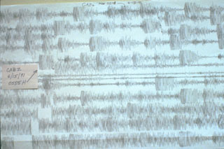 The seismogram for 15 June 1991 shows the intense seismicity accompanying the catastrophic eruption of Mount Pinatubo in the Philippines. This seismic record shows earthquakes over a two-hour period beginning at 0508 hours. The arrow points to the earthquake accompanying a major explosion at 0555, which was preceded by long-period earthquakes. At about 0640 continuous overlapping long-period earthquakes or tremor began, and much of the following record was saturated so that individual earthquakes could not be distinguished.
 Photo by Ed Wolfe, 1991 (U.S. Geological Survey).
 The small tuff cone in the center of this photo was produced towards the end of a powerful 1965 explosive eruption of Taal in the Philippines. The eruption from 28 to 30 September originated from a fissure on the SE flank of Volcano Island and produced devastating pyroclastic surges when lake water gained access to the vent. The vent is filled by an inlet of Lake Taal in this 1965 post-eruption photo from the S. Eruptions the following year almost completely filled this new inlet.
Photo by Jim Moore, 1965 (U.S. Geological Survey).
 An ash plume rises to 12.5 km above the summit of Mayon volcano on 13 September 1984, seen here from Santa Misericordia on the E flank. This marked the peak of the first phase of the eruption which began on 9 September. The first phase lasted until 18 September and included the eruption of pyroclastic flow that traveled down the NNW flank and lava flows down the SW.
Photo by N.B. Gallegos, 1984 (Philippine Institute of Volcanology and Seismology).
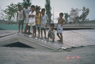 Children stand on top of a school building buried to its roof on 12 October 1991. The school was initially partially buried by lahars from Pinatubo along the Bambam River on 24 August. Successive lahars along this NE-flank valley had traveled 50 km by the end of 1991.
Photo by Chris Newhall, 1991 (U.S. Geological Survey).
 Bulusan, seen here from the W, is the southernmost volcano on the island of Luzon. It has formed within the 11-km-wide Irosin caldera along with other cones and domes. Frequent moderate explosive eruptions have been recorded since the mid-19th century from craters at the summit.
Photo by Chris Newhall, 1984 (U.S. Geological Survey).
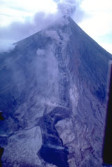
 The upper flanks of the symmetrical Mayon are exceptionally steep, averaging 35-40 degrees. They are covered with solidified lava agglutinate, the molten ejecta of lava fountains. This 1984 photo from the WSW shows a 250-m-deep, 3-km-long gully in the shadow at the right that was eroded by pyroclastic flows during the 1984 eruption.
Photo by Chris Newhall, 1984 (U.S. Geological Survey).
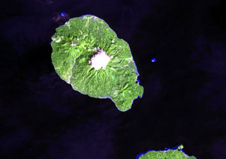
 Babuyan Claro is one of five Pleistocene-to-Holocene volcanic centers occupying Babuyan de Claro Island north of Luzon. The largest edifice is Mt. Pangasun with two summit craters 300 and 400 m in diameter. Adjacent edifices include Mount Cayonan, Mount Naydi, and Mount Dionisio; the youngest volcano on the island is Smith volcano. Askedna Hot Spring is located at the southern base of Babuyan Claro.
Photo courtesy of PHIVOLCS.
 Volcanic ash is composed of heavy pulverized rock. Ashfall from the 15 June 1991 eruption of Pinatubo in the Philippines accumulated on this this World Airways DC-10, shifting the center of gravity and causing the nose to tip up. About 4 km3 of ash was erupted on 15 June. It accumulated to depths of 10-15 cm at this airfield at the Cubi Point Naval Air Station, 40 km SSW of Pinatubo.
Photo by R.L. Rieger, 1991 (U.S. Navy).
 The entire foreground area in this view of Iriga volcano is a massive 1.5 km3 debris avalanche deposit formed by a Holocene landslide. This view from the SE shows the typical hummocky debris avalanche topography. Many of the darker areas are tree-covered hummocks; the irregular topography of the also creates many small ponds.
Photo by Chris Newhall (U.S. Geological Survey).
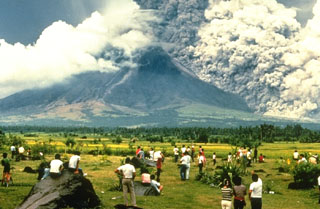 A crowd of spectators watches a pyroclastic flow sweeping down the SE flank of Mayon volcano on 24 September 1984. They stand on the surface of a deposit from a large lahar emplaced during an eruption in 1814. The pyroclastic flow seen here traveled about 6 km. Strong explosions the previous day created notches in the SE and east crater rims that funneled pyroclastic flows down ravines in those directions.
Photo by Norm Banks, 1984 (U.S. Geological Survey).
 The 61-km-long Jolo island contains numerous cones and craters, some of which are visible in this August 2019 Planet Labs satellite image monthly mosaic (N is at the top). The 1.3-km-diameter lake-filled crater visible in the center of the island is Mount Panamao.
Satellite image courtesy of Planet Labs Inc., 2019 (https://www.planet.com/).
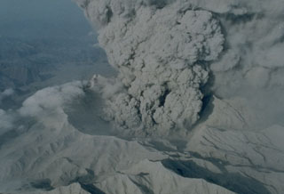 An ash plume rises from the new caldera of Pinatubo volcano on 22 June 1991. The 2.5-km-wide caldera, seen here from the N, was formed by collapse of the summit following a Plinian eruption on 15 June. Ash plumes continued for about a month before becoming intermittent prior to the end of the eruption on 2 September. Light-colored ash deposits cover the flanks of the formerly forest-covered volcano.
Photo by R. Batalon, 1991 (U.S. Air Force).
 The Latukan summit is the lighter green area near the center of this 10 August 2019 Sentinel-2 satellite image (N is at the top). Located in NW Mindanao, Makaturing volcano is W and Ragang is NE.
Satellite image courtesy of Copernicus Sentinel Data, 2019.
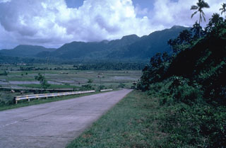
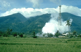 Malinao is forested with a summit crater that opens towards the east. The Tiwi geothermal field, seen here with the volcano in the background, is located on the E flank. The geothermal field is located near Luzon's largest fumarole field, which includes siliceous sinter deposits at Naglabong.
Photo by Chris Newhall (U.S. Geological Survey).
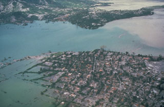 Floodwaters back up over the villages of Aglao and Dalanawan on the SW flank of Pinatubo volcano in the Philippines. Lake Mapanuepe was formed when lahars from the 1991 eruption traveled down the Marella River and dammed its tributary; several villages were submerged by the rising water. The lake was stabilized in late 1992 at about this level after excavation of a trench through bedrock, seen in the background. This prevented catastrophic rapid draining of the lake.
Photo by Chris Newhall, 1991 (U.S. Geological Survey).
 An ash plume rises above a vent on the SW side of Volcano Island at Taal on 30 September 1965, during a two-day eruption that began on the 28th. The white plume at the bottom is a horizontally moving base surge. The devastating pyroclastic surges caused 150 fatalities.
Photo by L.E. Andrews, 1965 (courtesy of Jim Moore, U.S. Geological Survey).
 Mount Iriga has a horseshoe-shaped crater opening to the SE that resulted from a large flank collapse during a Holocene eruption. The hummocky terrain in the foreground encloses small ponds on the surface of the debris avalanche deposit.
Photo by Chris Newhall (U.S. Geological Survey).
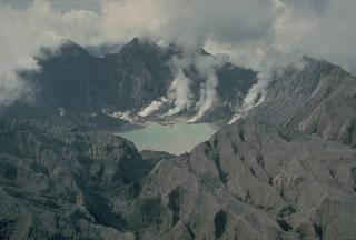 The major explosive eruption on 15 June 1991 created a 2.5-km-wide caldera at the summit of Pinatubo. The elevation of the caldera floor is more than 900 m below that of the pre-eruption summit. Plumes rise from fumaroles on the caldera floor in this 4 October 1991 photo taken from the N. The outer flanks of the caldera are stripped of vegetation and covered with ash and pyroclastic surge deposits.
Photo by Chris Newhall, 1991 (U.S. Geological Survey).
 The forested Maquiling volcano (center) rises south of Laguna de Bay (top) and is the highest point of the San Pablo volcanic field. It has a deep crater whose floor is 480 m below its N rim and several cones, maars, and numerous thermal areas at its northern base, and other maars and scoria cones of the San Pablo volcanic field lie to the E. The prominent dark-colored maar along the shore of Laguna de Bay north of Maquiling is Alligator Lake.
NASA Landsat image, 2002 (courtesy of Hawaii Synergy Project, Univ. of Hawaii Institute of Geophysics & Planetology).
 Bulusan, seen here from the south, rises above the low-lying floor of Irosin caldera and is the youngest of several cones and lava domes constructed within the caldera. The city of Irosin is the largest community within the caldera, which formed more than 36,000 years ago. Historical eruptions of Bulusan have occurred at summit vents and flank vents also are found low on the SE side.
Photo by Chris Newhall (U.S. Geological Survey).
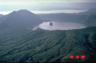 A 3-km-wide caldera is located at the center of Volcano Island, in the Philippines' southern Luzon Island. The 5-km-wide Volcano Island lies within the much larger 15 x 20 km Taal caldera, of which the western wall is seen across Lake Taal in the distance. The small island in the center of the photo is a remnant of historical eruptions on Volcano Island and is an island in a lake, on an island in a lake, on an island.
Photo by Chris Newhall, 1989 (U.S. Geological Survey).
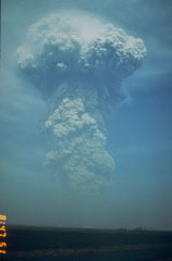 A large ash plume rises above the NW flank of Pinatubo at 0841 on 13 June 1991. Weather radar indicated that the plume reached an altitude of at least 24 km. Pyroclastic flows from this eruption extended 4-5 km down the Maraunot drainage on the NW flank. At the end of this eruption the NW-flank lava dome that had begun growing on 7 June was still intact.
Photo by Rick Hoblitt, 1991 (U.S. Geological Survey).
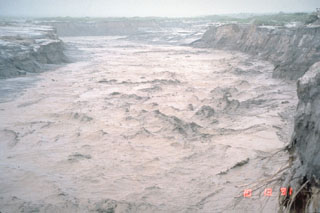 A lahar, or volcanic mudflow, fills the banks of the Pasig-Potrero River on the east side of Pinatubo volcano in the Philippines on 13 October 1991. The lahar moved at a velocity of 3-5 m/s and carried a few meter-sized boulders. This lahar was not directly produced by an eruption, but was triggered by minor rainfall that remobilized thick deposits of ash and pumice that blanketed the landscape. Devastating lahars occurred at Pinatubo for years after the catastrophic 1991 eruption.
Photo by Chris Newhall, 1991 (U.S. Geological Survey).
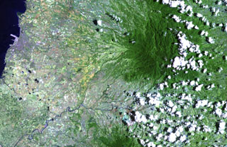 The deeply eroded, forested Mandalagan volcano on northern Negros Island contains a highly altered domed structure. The Bago River at the bottom of the image cuts across the lowlands between Mandalagan and Kanlaon volcano, whose vegetated flanks are visible at the bottom center.
NASA Landsat image, 2003 (courtesy of Hawaii Synergy Project, Univ. of Hawaii Institute of Geophysics & Planetology).
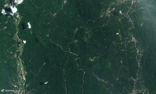 The Paco-Maniayao volcanic complex is located on the peninsula forming the NE tip of Mindanao and is seen here in this 15 August 2019 Sentinel-2 satellite image (N is at the top). The complex contains several craters and lava domes. This image is approximately 10 km across.
Satellite image courtesy of Copernicus Sentinel Data, 2019.
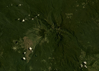 Ragang volcano in central Mindanao is in the center of this August 2019 Planet Labs satellite image monthly mosaic (N is at the top; this image is approximately 24 km across). Latukan is to the SW, past lava flows with visible levees and pressure ridges that appear to have erupted from flank vents.
Satellite image courtesy of Planet Labs Inc., 2019 (https://www.planet.com/).
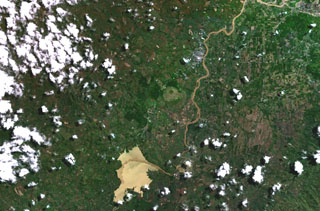 The small, circular light-green area just left of the river in this NASA Landsat image (with north to the top) is Musuan volcano. This andesitic-to-dacitic lava dome and tuff cone, also known as Calayo, rises more than 600 m above flat farmland in the province of Bukidnon in central Mindanao Island in the southern Philippines.
NASA Landsat 7 image (worldwind.arc.nasa.gov)
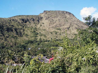 Mt. Vulcan, a lava dome on the NW flank of the Hibok-Hibok lava-dome complex, formed during the 1871-1875 eruption. Following earthquakes beginning in January 1871, an explosion occurred on 30 April from a vent on the NW flank near the coast, destroying an area with a 3 km radius. Explosive activity continued for about a week, after which lava effusion began. Dome growth lasted for four years, producing by 1875 a dome about 1.6 km in diameter.
 Photo by Juny La Putt, 2002.
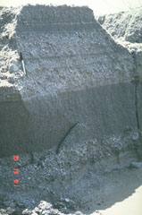 These relatively fine-grained layers are lahar deposits produced by successive overflows of dikes along the Bambam River, about 35 km NE of Pinatubo volcano in the Philippines. The photo was taken on 13 October 1991, a little more than a month after the end of the devastating 1991 eruption. Note the pen at the upper left for scale. By the end of 1991, rainfall-induced lahars had traveled 50 km down the Bambam River.
Photo by Chris Newhall, 1991 (U.S. Geological Survey).
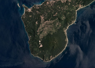 Camiguin de Babuyanes is located in southern Camiguin Island in the Babuyan archipelago, north of Luzon Island, and is seen in this June 2019 Planet Labs satellite image monthly mosaic (N is at the top). At this point the island is around 5 km wide. The volcano includes the Camiguin edifice, along with Minabul and Caanoan cones to the N and E, respectively.
Satellite image courtesy of Planet Labs Inc., 2019 (https://www.planet.com/).
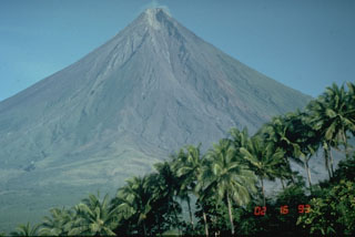 Mayon in the Philippines is one of Earth's best examples of a classic, conical stratovolcano. Its symmetrical morphology is the exception rather than the rule and is the result of eruptions that are restricted to a single central conduit at the summit. Eruptions are frequent enough to overcome erosion processes that quickly modify the slopes of most volcanoes.
Photo by Chris Newhall, 1993 (U.S. Geological Survey).
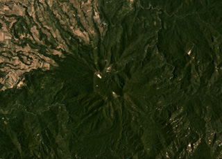 The roughly 2-km-wide Cagua summit crater is in the center of this April 2019 Planet Labs satellite image monthly mosaic (N is at the top), at the NE peninsula of Luzon island. The flanks contain thick pyroclastic flow deposits that were emplaced 600,000 to 300,000 years ago and are now eroded.
Satellite image courtesy of Planet Labs Inc., 2019 (https://www.planet.com/).
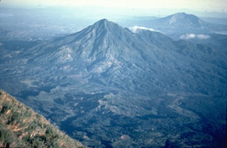 Masaraga rises NW of Mayon volcano. This view from near the summit of Mayon also shows Mount Iriga (upper right), with its large horseshoe-shaped crater.
 Photo by Chris Newhall (U.S. Geological Survey).
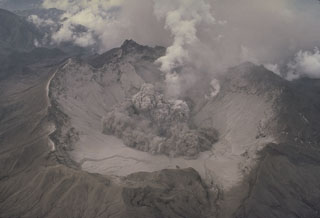 The beginning of a small explosion within the new summit caldera of Pinatubo is seen from the NE on 1 August 1991. After the 2.5-km-wide caldera formed during the 15 June climactic eruption, frequent ash emission lasted through much of July. The caldera floor became visible for the first time when activity changed to intermittent explosions. By September 1991 a lake began to form from the accumulation of rainwater and groundwater from within the volcano; it eventually expanded to cover the caldera floor.
Photo by Tom Casadevall, 1991 (U.S. Geological Survey).
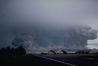 A powerful eruption of Pinatubo that began at 0555 on 15 June 1991 viewed from Clark Air Base ENE of the volcano. The broad ash column, which appears to be as wide as the volcano, is a result of pyroclastic flows that are sweeping radially down the volcano's flanks. Eruptions producing pyroclastic flows began on 12 June and continued intermittently until the climactic eruption that began at 1342 on the 15th and resulted in caldera collapse during sustained eruptions that lasted more than 6 hours.
Photo by Robert LaPointe, 1991 (U.S. Air Force).
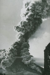 As ash plume rises above the summit of Mayon volcano on 27 April 1968 as pyroclastic flows travel down the SW and S flanks. This view from the SSW flank shows the Camalig church to the right, which was damaged by pyroclastic flows during the 1814 eruption. The 1968 eruption began on 21 April and lasted until 20 May.
Photo courtesy of William Melson, Smithsonian Institution, 1968.
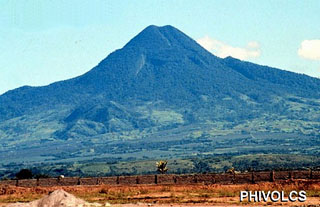 The forested Matutum is located in southern Mindanao. The summit contains a densely forested 320-m-wide and 120-m-deep crater. Widespread pyroclastic flow deposits surround the volcano, which overlooks the major city of General Santos about 30 km to the SSE.
Photo courtesy of PHIVOLCS.
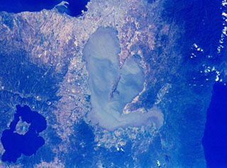 The center Laguna de Bay in the center of the NASA Space Shuttle image (N is to the upper right) is Laguna Caldera. The lake surface is only 1 m above sea level and may have formed during at least two major explosive eruptions about 1 million and 27,000-29,000 years ago. The city of Manila lies along Manila Bay at the top center, and the large caldera at the lower left is Taal. To the right is the Pacific Ocean.
NASA Space Shuttle image, 1992 (http://eol.jsc.nasa.gov/).
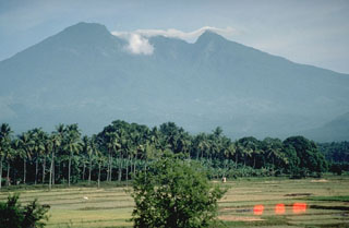 Mount Banahaw is the highest of a group of volcanoes S and E of Manila. The smaller San Cristóbal and Banáhao de Lucban have formed on the W and E flanks, respectively. This view from the SW shows a valley descending from the summit that formed or deepened during the outbreak of a crater lake in 1730. Collapse events produced two major debris avalanches, the largest of which traveled 26 km SE to the sea, where it forms a 10-km-long section of Tayabas Bay coastline.
Photo by Chris Newhall, 1989 (U.S. Geological Survey).
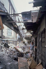 Heavy ashfall from the 15 June 1991 eruption of Pinatubo caused collapse of the roof of this public market in Olapango City near Subic Bay Naval Air Station. About 10-15 cm of ash fell at this location, 35 km S of the volcano.
Photo by Tom Casadevall, 1991 (U.S. Geological Survey).
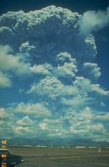 A large Plinian ash plume from Pinatubo towers above Clark Air Base on 12 June 1991. The eruption column reached an altitude of 19 km. This was the first in a series of powerful eruptions that reached a climax on 15 June. The eruption that day produced a series of large pyroclastic flows that covered all sides of the volcano and resulted in collapse of the summit, creating a 2.5-km-wide caldera.
Photo by Dave Harlow, 1991 (U.S. Geological Survey).
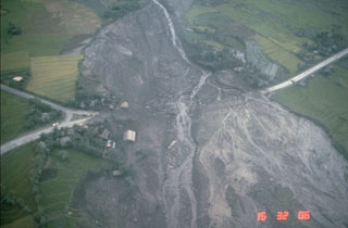 Lahars from the 1984 eruption of Mayon volcano swept down the NW and SW flanks. This 24 September view shows lahar deposits burying the highway at the Santa Domingo junction on the lower E flank, about 8 km from the summit. Lahars from this eruption reached the Albay Gulf at several points.
Photo by Norm Banks, 1984 (U.S. Geological Survey).
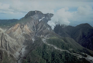 An aerial view of the north flank of Pinatubo shows the area devastated by explosions on 2 April 1991. This eruption was the first in a progressively intensifying series of eruptions that led to caldera formation on 15 June. The road in the foreground provided access to a geothermal drill station.
Photo by Chris Newhall, 1991 (U.S. Geological Survey).
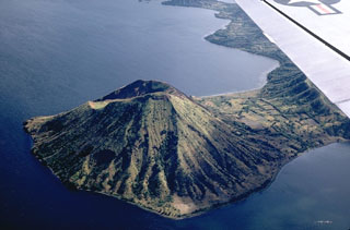 Binintiang Malaki, a cone at the NW tip of Volcano Island, formed during an eruption in 1707. The cone, seen here from the SW, is the largest of the flank cones on Volcano Island.
Photo by Kurt Frederickson, 1968 (Smithsonian Institution).
 Meteorological clouds drape the sparsely vegetated summit of Kanlaon, the most active volcano of the central Philippines and the highest point of Negros Island. It contains different cones and craters, many of which are filled by lakes. Historical eruptions, recorded since 1866, have typically consisted of small-to-moderate phreatic explosions that produce minor ashfall near the volcano.
Photo courtesy of PHIVOLCS.
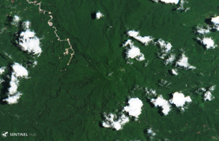 The Labo volcanic center in SE Luzon contains numerous lava domes and lahar deposits, and extensive geothermal activity. This 25 April 2019 Sentinel-2 satellite image (N is at the top) is approximately 10 km across and shows the summit area of the main edifice in the center.
Satellite image courtesy of Copernicus Sentinel Data, 2019.
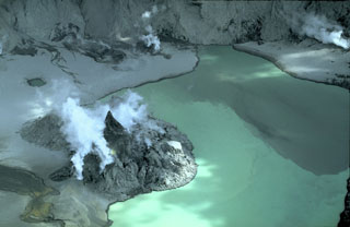 An eruption that began on 9 July 1992 produced a small tuff cone on the floor of the Pinatubo caldera. On 14 July a new lava dome was sighted, which by the end of the eruption on 30 October had grown to a height of more than 100 m and covered an area of 300 x 400 m. This view from the S shows the dome on 8 March 1993. Subsequent rise of the lake level covered much of the dome by 1994, leaving two small islands in the caldera lake.
Copyrighted photo by Stephen O'Meara, 1993.
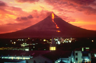 An incandescent lava flow, seen in this sunset view from Legaspi City, descends the SE flank towards the village of Buyuan on 27 March 1993. The eruption began on 2 February with an explosion and pyroclastic flow that traveled 6 km down the E flank and killed 75 people. During the rest of the eruption, which ended in early April, slow lava effusion was accompanied by small pyroclastic flows and ash emissions.
Photo by Philippine Institute of Volcanology and Seismology, 1993.
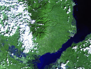 The forested Malindang stratovolcano (center) is located on the western margin of Iligan Bay in north-central Mindanao. The volcano contains a small summit caldera and legends discuss a large eruption. Reports of increased activity in 1991 at the time of tectonic earthquakes prompted widespread evacuations, but an eruption did not occur.
NASA Landsat image, 2002 (courtesy of Hawaii Synergy Project, Univ. of Hawaii Institute of Geophysics & Planetology).
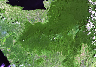 Several prominent pyroclastic cones are visible on the flanks of Makaturing volcano (left of center), located NE of Illana Bay (lower left) and south of Lake Lanao (upper left) at the west end of a chain of volcanoes in central Mindanao. Eruptions from this volcanic chain have variously been attributed to Makaturing and the historically active Ragang.
NASA Landsat image, 2003 (courtesy of Hawaii Synergy Project, Univ. of Hawaii Institute of Geophysics & Planetology).
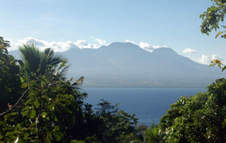 The broad Cuernos de Negros volcanic complex is seen here from the small island of Apo, 7 km SE of the city of Zamboanguita at the southern end of Negros Island. The eastern side of the complex consists of two cones and a lava dome with two crater lakes up to 1.5 km in diameter. The small summit crater of Magaso, the highest peak of the complex, rises above the city of Dumaguete and contains fumaroles. The Palinpinon geothermal field is located on the north side of the volcano.
Photo by Arne Kuilman, 2007.
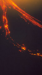 An incandescent lava flow descends the SW flank of Mayon (left). This 18 September 1984 time-lapse photo taken from near Masarawag also shows incandescent blocks to the right that were ejected by explosive eruptions and are cascading down the south flank.
Photo by Emmanuel Ramos, 1984 (Philippine Institute of Volcanology and Seismology).
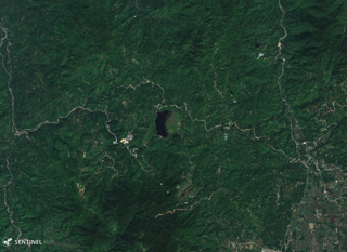 The 1.8-km-long (N-S) arcuate lake in the center of this 15 November 2019 Sentinel-2 satellite image (N is at the top) is Lake Leonard, located within a caldera of the Leonard Range in Mindanao Island. Around the lake are a series of lava domes and active geothermal areas.
Satellite image courtesy of Copernicus Sentinel Data, 2019.
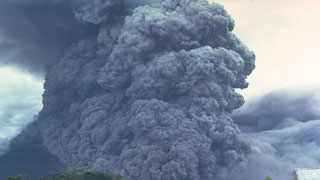 A pyroclastic flow travels down the SE flank of Mayon volcano in the Philippines on 24 September 1984. An ash plume rises above the moving pyroclastic flow, which was the largest of a series of pyroclastic flows that occurred during an eruption that began on 9 September. The pyroclastic flow traveled 7 km from the summit vent; velocities of 50 m/s were estimated from photographs.
Photo by Ernesto Corpuz, 1984 (Philippine Institute of Volcanology and Seismology).
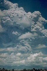 A large Plinian ash plume towers above Pinatubo in the Philippines on 12 June 1991, reaching an altitude of 19 km. This was the first in a series of powerful eruptions that culminated on 15 June with major pyroclastic flows that traveled down all sides of the volcano. Collapse of the summit then created a 2.5-km-wide caldera. This photo was taken from Clark Air Base, about 25 km ENE of Pinatubo.
Photo by Karin Jackson, 1991 (U.S. Air Force).
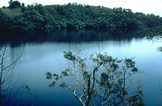 Alligator Lake, along the southern shore of Laguna de Bay, is one of a group of dozens of maars and scoria cones forming the San Pablo volcanic field (also known as the Laguna volcanic field). Three generations of maars are present, the youngest of which contain deep lakes. Many of the maars are located along a NE-SW trend. Local legends indicate that the most recent eruption occurred about 500-700 years ago at Sampaloc Lake, 17 km SE of Alligator Lake.
Photo by Chris Newhall, 1989 (U.S. Geological Survey).
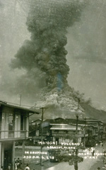 This commercial print of an eruption of Mayon volcano on June 7, 1938, shows a powerful vertical eruption column rising above the summit and pyroclastic flows sweeping down the flanks. During this eruption a lava flow traveled down the east flank to 570 m elevation, and shorter lava flows descended the SSW, west, NW, and NNE flanks.
From the collection of Maurice and Katia Krafft.
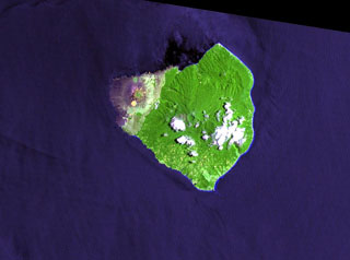 Mount Babuyan is the youngest of five Pleistocene-to-Holocene volcanic centers on the island of Babuyan Claro. The largest edifice is the active Mt. Pangasun (Babuyan Claro), with two summit craters 300 and 400 m in diameter. Both Babuyan Claro and Smith volcanoes have apparently been active in historical time, although which volcano produced the eruptions is not certain.
NASA Landsat image, 2000 (courtesy of Hawaii Synergy Project, Univ. of Hawaii Institute of Geophysics & Planetology).
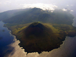 Babuyan (also called Smith volcano) in the foreground is one of five Pleistocene-to-Holocene volcanic centers occupying Babuyan de Claro Island N of Luzon. The symmetrical scoria cone is the youngest volcano on the island. Both the higher Babuyan Claro (Mt. Pangasun) and Babuyan have apparently been active in historical time, although the identity of the erupting volcano is not always certain.
Photo by Bing Ramos, 2006 (http://en.wikipedia.org/wiki/Image:Didicas_Volcano_1.jpg).
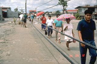 Residents of the city of Bacolor in the Philippines, 38 km SE of Pinatubo, persevere in the face of widespread devastation from lahars. They are walking on the surface of a solidified 5-m-deep deposit of volcanic debris next to wires that are the original electrical power lines formerly high above the street level. Houses and businesses in the background of this September 1995 photo are buried to 2nd-floor levels.
Photo by Chris Newhall, 1995 (U.S. Geological Survey).
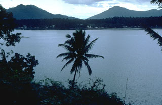 Local legends suggest that the latest eruption of the San Pablo volcanic field took place about 500-700 years ago, forming the Sampaloc Lake maar. This 1.2-km-wide maar, seen here from the S, is one of the largest of a group of 36 maars in the volcanic field.
Photo by Chris Newhall, 1989 (U.S. Geological Survey).
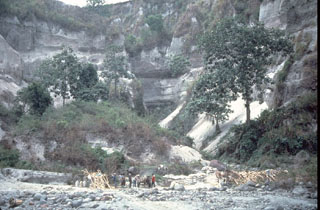 A thick stack of pre-1991 pyroclastic flow and lahar deposits outside Clark Air Base is testimony to the long history of explosive eruptions at Pinatubo. Six major eruptive periods took place in the past 35,000 years, each separated by long periods of quiescence. Most of the previous eruptive periods produced explosions that were even larger than the 1991 eruption. The last major eruption prior to 1991 occurred about 500 years ago.
Photo by Chris Newhall (U.S. Geological Survey).
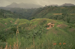 Parker volcano, seen here from the E, is located at the S end of Mindanao Island in the Philippines. Reconnaissance studies of the volcano revealed resemblances to Pinatubo volcano, which also produced thick of pyroclastic flow deposits around its flanks. Parker is now thought to be the source of a major eruption in 1641 that plunged much of Mindanao into darkness.
 Photo by Chris Newhall (U.S. Geological Survey).
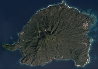 The eroded Balut edifice is in the center of this December 2019 Planet Labs satellite image monthly mosaic (N is at the top). Hot springs and thermally altered ground are located on the W and SW flanks. The island is approximately 11 km in the E-W direction.
Satellite image courtesy of Planet Labs Inc., 2019 (https://www.planet.com/).
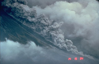 Pyroclastic flows are hot avalanches of rock, ash, and gas that sweep down the flanks of volcanoes at high velocities. This photo shows a relatively small pyroclastic flow at Mayon volcano in the Philippines on 23 September 1984. These hot, ground-hugging flows can travel at velocities to about 100 km/hour and reach areas well beyond the flanks of a volcano. Their high temperatures make them lethal to anything in their path. Hot ash plumes rise above the denser basal portion that can contain abundant solid blocks and ash.
Photo by Chris Newhall, 1984 (U.S. Geological Survey).
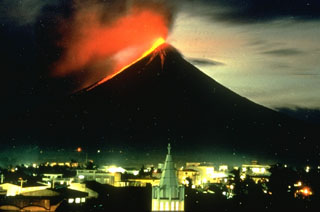 A nighttime view from Legaspi City on 14 September 1984 shows incandescent lava flows descending the SW flank of Mayon volcano in the Philippines. The flows traveled about 4 km to the lower flanks of the volcano, adjacent to previous flows from eruptions in 1968 and 1978.
Photo by Norm Banks, 1984 (U.S. Geological Survey).
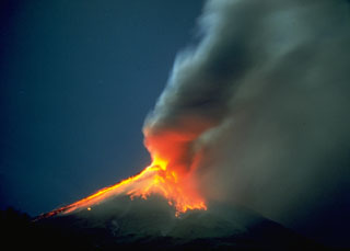 This time-lapse photo taken on 12 September 1984 shows incandescent blocks that were ejected by explosive eruptions and are cascading down the flanks of Mayon. The incandescence is reflected in the base of the ash plume to the right.
 Photo by Rene Arcante, 1984 (courtesy Philippine Institute of Volcanology and Seismology).
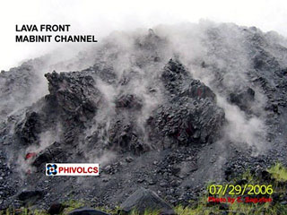 A lava flow front at Mayon is seen here on 29 July 2006 as it continued to advance down the Mabinit channel. Phreatic eruptions had begun on 13 July and lava extrusion was noted the following day, eventually reaching over 6 km to the SSE. Intermittent explosions continued and lava effusion ceased on 1 October. Pyroclastic flows occurred on 20 July and 12 August.
 Photo courtesy of C. Sagution, 2006 (PHIVOLCS).
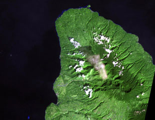 Balatukan (also known as Balatocan) is located in north-central Luzon, along this peninsula SE of Camiguin Island. There are active fumaroles, but it is extensively eroded and the age of its latest eruption is not known.
NASA Landsat image, 2002 (courtesy of Hawaii Synergy Project, Univ. of Hawaii Institute of Geophysics & Planetology).
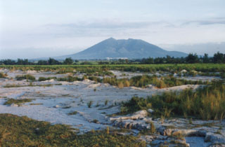 Arayat, seen here from the SW near the city of Angeles, is one of the few topographic features that rise above the flat Central Plain of Luzon Island. A broad valley can be seen here down the western flank of the volcano. There are no reports of historical eruptions from Arayat.
Photo by Ichio Moriya (Kanazawa University).
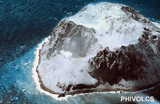 Didicas volcano, 22 km NE of Camiguin Island, was a submarine volcano prior to becoming a permanent island in 1952. The first recorded submarine eruption of Didicas was in 1773. A 400-m-wide crater formed during the 1952 eruption, and two eruptions have occurred since then at a crater on the northern side of the island.
Photo courtesy of PHIVOLCS.
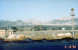 The summit of Pinatubo is seen from the E at Clark Air Base in 1992. The unvegetated peak near the center is the southern rim of the new caldera and summit. The northern caldera rim lies about 2/3 of the distance between the summit and the unvegetated peak to the right, which is the relict caldera rim of ancestral Pinatubo volcano.
Photo by Rick Hoblitt, 1992 (U.S. Geological Survey).
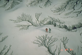 The unconsolidated pyroclastic flow and ash deposits emplaced during the June 1991 eruption of Pinatubo were remobilized by rain water as lahars for years after activity ceased. This photo shows erosion patterns in the deposits along the Maraunot River valley NW of Pinatubo on 27 November 1991.
Photo by Chris Newhall, 1991 (U.S. Geological Survey).
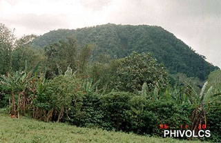 Forested Bud Dajo cinder cone is one of numerous pyroclastic cones and craters that dot 60-km-wide Jolo Island at the SW end of the Philippines archipelago. Bud Dajo (or Buddajo) is a young basaltic cinder cone that reaches 620 m elevation; nearby cones are Matanding, Guimba, and Sungal. Hot springs have been reported at craters on Cagayan Sulu, and solfataras at Siit Lake. A tsunami accompanied a possible submarine eruption in 1897.
 Photo courtesy of PHIVOLCS.
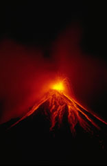 A Strombolian eruption on 15 September 1984 ejected incandescent blocks that rolled down the flanks of Mayon. Sustained lava fountaining produced lava agglutinate that congealed on the upper flanks around the vent. This eruption, which began on 9 September, also produced powerful vertical explosions and pyroclastic flows that traveled out to 7 km from the summit.
Photo by Ernesto Corpuz, 1984 (Philippine Institute of Volcanology and Seismology).
 The 1991 eruption of Pinatubo in the Philippines created a new caldera with an average diameter of 2.5 km. Caldera collapse occurred following the ejection of around 5 km3 of material in one of the world's largest eruptions of the 20th century and lowered the height of the volcano by about 300 m. This 1994 view from the NW shows a lake within the caldera and two small islands from a partially submerged lava dome that was erupted in 1992.
Photo by Ray Punungbayan, 1994 (Philippine Institute of Volcanology and Seismology).
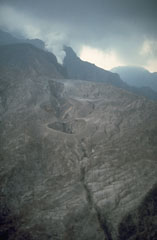 The 1991 eruption of Pinatubo began on 2 April with a small phreatic eruption on the upper NW flank. The eruptions formed several craters along a 1.5-km-long, E-W-trending alignment. Steam rises from a vent at the SW end of the fissure. Activity continued at two of these vents through April-May and increased prior to extrusion of a small lava dome at a NW-flank vent on 7 June.
Photo by Chris Newhall,1991 (U.S. Geological Survey).
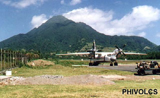 Iraya rises above the airport on Batan Island and is the northernmost active volcano in the Philippines. It has a 1.5-km-wide summit crater, which is largely filled by a younger cone that forms the summit. A pyroclastic flow deposit was radiocarbon dated at about 1,500 years ago and a historical eruption was reported in 1454 CE.
Photo courtesy of PHIVOLCS.
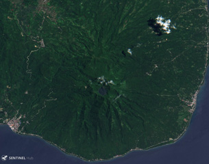 The summit of Cabalían contains a crater lake, visible near the center of this 10 August 2019 Sentinel-2 satellite image (N is at the top) which is approximately 11 km across. The Cantoloc cone is immediately N of the main crater, and geothermal activity occurs on the eroded E and W flanks.
Satellite image courtesy of Copernicus Sentinel Data, 2019.
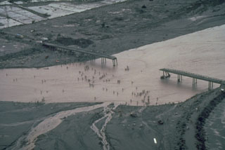 Residents in this July 1991 photo had to cross the shallow Santo Tomás River, SW of Pinatubo, on foot after lahars (volcanic mudflows) destroyed the bridge between the villages of San Rafael and Santa Fe. Devastating lahars affected broad lowland areas on all sides of Pinatubo in the years following the 1991 eruption.
Photo by Chris Newhall, 1991 (U.S. Geological Survey).
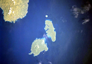 The Sarangani Islands lie about 20 km across Sarangani Strait from the Batulaki Peninsula (upper left), which forms the southern tip of Mindanao Island. Balut volcano occupies the lower island in this NASA Space Shuttle image (N is to the upper left). The volcano has hot springs and areas on the flanks have undergone thermal alteration.
NASA Space Shuttle image STS099-704-41, 2000 (http://eol.jsc.nasa.gov/).
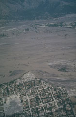 Lahars from Pinatubo fill the broad Santo Tomás River valley SW of the volcano. Erosion along the south bank of the river has cut into the town of San Rafael. This photo was taken a month after the end of the 1991 eruption. Lahars produced by the redistribution of thick deposits of ashfall and pyroclastic flows caused extensive long-term economic devastation which continued for years after the eruption ended.
Photo by Chris Newhall, 1991 (U.S. Geological Survey).
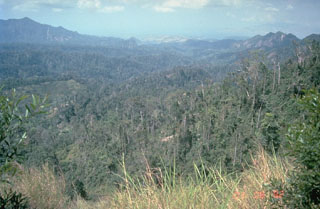 The summit of Mount Natib, south of Pinatubo, contains a 6 x 7 km caldera seen here in this view from the NE caldera rim. Five thermal areas are found in the summit region.
Photo by Chris Newhall, 1989 (U.S. Geological Survey).
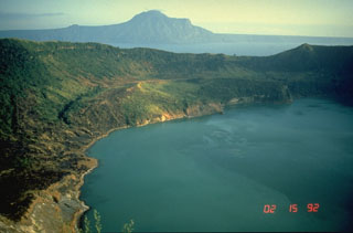 This view of Main Crater Lake in the 3-km-wide caldera on Volcano Island, looks across Lake Taal to the NE rim of the 15 x 20 km Taal caldera. The surface of the 267 km2 lake is only 3 m above sea level. Volcano Island has been the source of explosive eruptions with pyroclastic surges that devastated lakeshore areas. Pleistocene eruptions that formed the caldera greatly modified the topography of southern Luzon Island.
Photo by Chris Newhall, 1989 (U.S. Geological Survey).
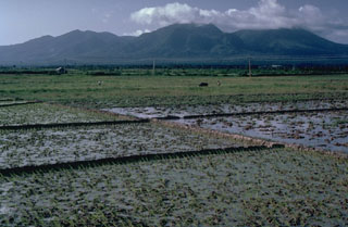 The linear Pocdol Mountains lie between Saragon Bay and the Albay Gulf in southern Luzon. This view is from the S, near the town of Sosogon. A geyser and fumaroles are located near the summit. Little is known of their geologic history.
Photo by Chris Newhall (U.S. Geological Survey).
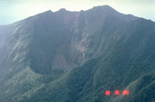 This view looks W into the Iriga crater that formed at the base of the 600-m-high headwall scarp of a flank collapse during a Holocene eruption.
 Photo by Chris Newhall (U.S. Geological Survey).
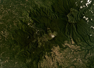 The Apo volcanic complex is composed of four edifices and several smaller cones, with the Apo dome being the youngest feature. The edifice is in the center of this August 2019 Planet Labs satellite image, which is approximately 24 km across. Geothermal activity continues in the area with a power plant within 3 km of the Apo dome.
Satellite image courtesy of Planet Labs Inc., 2019 (https://www.planet.com/).
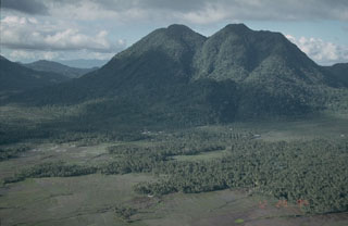 Mount Jormajan, a large lava dome on the east side of Bulusan volcano, was constructed at the W side of the 11-km-wide Irosin Caldera. This view from the south shows the flat caldera floor in the foreground, with the western caldera wall visible to the far left.
Photo by Chris Newhall (U.S. Geological Survey).
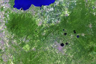 Lake-filled maars are common features of the San Pablo Volcanic Field at the southern end of the large Laguna de Bay (top). The monogenetic volcanic field contains a group of 42 scoria cones and 36 maars, the youngest of which contain deep lakes. The largest maar in this Landsat image is 1.2-km-wide Sampaloc Lake, immediately N of the city of San Pablo. Local legends suggest that this maar formed about 500-700 years ago. The forested volcano to the left is Maquiling.
NASA Landsat image, 2002 (courtesy of Hawaii Synergy Project, Univ. of Hawaii Institute of Geophysics & Planetology).
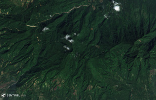 This 1 February 2019 Sentinel-2 satellite image (N is at the top) shows part of southern end of the 35-km-long volcanic island of Biliran, located across the narrow Biliran Strait from the northern tip of Leyte Island (left). Lava domes, craters, and geothermal areas have formed around the island.
Satellite image courtesy of Copernicus Sentinel Data, 2019.
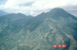 Vegetated Masaraga, seen here from the south, is located NW of Mayon volcano. An eroded volcanic ridge extends to the NW and thick lava flows have been emplaced on the flanks
Photo by Chris Newhall (U.S. Geological Survey).
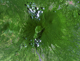 The large 2-km-wide, 600-m-deep crater that extends down the SSW flank of Banahaw contained a crater lake until 1730, when it drained, producing lahars. The smaller San Cristóbal and Banáhao de Lucban have formed on the W and E flanks, respectively. Andesite-to-dacite lava domes formed on the flanks of Banahaw and San Cristobal.
NASA Landsat image, 2002 (courtesy of Hawaii Synergy Project, Univ. of Hawaii Institute of Geophysics & Planetology).
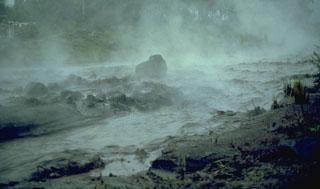 A hot lahar sweeps down a channel on the SW flank of Mayon in the Philippines on 14 September 1984, five days after the onset of an eruption. The water temperature of this lahar was about 80°C. Note the large block in the center of the channel that is being transported by the lahar.
Photo by Ernesto Corpuz, 1984 (Philippines Institute of Volcanology and Seismology).
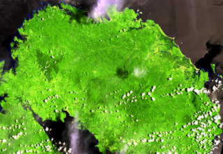 This Landsat image shows the forested Labo lies between the Ragay Gulf (lower left) and Pacific Ocean (top) at the NW end of the Bicol Peninsula in SE Luzon. It is surrounded by numerous lava domes. Eruptive activity ceased during the Pleistocene, but thermal activity in the form of hot and warm springs continues.
NASA Landsat image, 2000 (courtesy of Hawaii Synergy Project, Univ. of Hawaii Institute of Geophysics & Planetology).
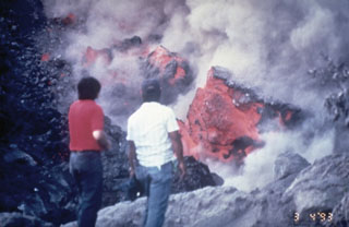 Volcanologists of the Philippines Institute of Volcanology and Seismology examine the front of a slow-moving lava flow that is advancing down the SW flank of Mayon volcano in March 1993. The incandescent interiors of lava blocks are exposed as they tumble down the sides of the flow.
Photo by Philippine Institute of Volcanology and Seismology, 1993.
This is a compilation of Philippines volcano information sources, such as official monitoring or other government agencies.
| Volcano Observatories |
|---|
| Philippine Institute of Volcanology & Seismology (PHIVOLCS) |
| - PHIVOLCS Daily Reports |
| - PHIVOLCS Special Reports |
| - PHIVOLCS Alert Levels |
| - PHIVOLCS Facebook |
| - PHIVOLCS X |