Short lived plume rising to 50 m observed on 14 December 2011
The Japanese Meterological Agency (JMA) reported that a short-lived plume rose to 50 m above Akita-Komaga-take on 14 December 2011 and was recorded by a camera located to the N of Me-dake's summit.
Aerial observations were conducted in cooperation with the Japan Ground Self Defense Force on 13 December. Areas of snow melt corresponded to geothermal areas that had been previously identified. No new geothermal areas were found.
An M 2.6 earthquake on 27 December at 1234 local time occurred ~2 km W of Me-dake, with a maximum JMA Seismic Intensity of 1 in Senboku-city, Akita Prefecture. The JMA Seismic Intensity scale, used in Japan and Taiwan is classified into 10 categories; 0 to 4, 5 weak, 5 strong, 6 weak, 6 strong, and 7. The seismicity around the area had temporarily increased, but then returned to baseline levels. No volcanic activity related to this seismicity was observed.
JMA reported no activity at Akita-Komaga-take in 2012.
Information Contacts: Japan Meteorological Agency (JMA), 1-3-4 Otemachi, Chiyoda-ku, Tokyo 100-8122, Japan (URL: http://www.jma.go.jp/jma/en).
The Global Volcanism Program has no Weekly Reports available for Akita-Komagatake.
Reports are organized chronologically and indexed below by Month/Year (Publication Volume:Number), and include a one-line summary. Click on the index link or scroll down to read the reports.
Frequent explosions send ash columns up to 400 m high
Card 1017 (24 September 1970) Frequent explosions send ash columns up to 400 m high
"Akita-Komagatake volcano began a new eruption about 1400 TMT, 18 September. Columns of ash (up to 400m high) were emitted along with rumbling of the ground and drumming of explosion. On 19 September, the volcano was still active. Volcanic ashes and bombs were ejected at intervals of five to ten minutes. Explosions took place every 30 minutes. Occurrence of sulphurous acid gas was detected around the spot."
Information Contacts: Tokiko Tiba, Dept. of Geology, National Science Museum, Tokyo, Japan.
As many as 400-500 daily eruptions; continuing as of 8 October
Card 1031 (14 October 1970) As many as 400-500 daily eruptions; continuing as of 8 October
Akita-Komagatake volcano began a new eruption on 18 September 1970 and is still active on 8 October. The first eruption with ash columns, explosion sounds, and incandescent cinders was observed at about 2130 JST on 18 September and a small lava flow appeared. The eruption crater is located at the upper flank of Medake, the central cone of this volcano, where weak fumarolic areas appeared about three weeks ago. This is the first eruption since 1932 (phreatic explosion). The crater is 10-15 m in diameter, and explosion smoke including ash and lava blocks went up about 400 m high at intervals of 4-5 minutes, and a 40-70-m-wide lava flow (andesite: by Drs. Aramaki and Ossaka) reached a length of about 600 m from the crater. These Strombolian-type eruptions take place 400-500 times a day and air-shocks caused by explosions are frequently recorded by an installed seismograph. Seismic observation of this volcano has been in operation by JMA, Tohoku University, and Tokyo University, and petrological, geographical, and other geophysical investigations are [conducted] by many volcanologists. No damage is reported.
Information Contacts: Yosihiro Sawada, JMA.
Eruptions with explosion sounds, cinders, and smoke decrease in frequency
Card 1057 (27 November 1970) Eruptions with explosion sounds, cinders, and smoke decrease in frequency
Strombolian-type eruptions which began at medake in September are still active on 20 November 1970. The lava flow seems to be continuously supplied and was observed to be about 150 m wide and about 600 m long on 4 November. Eruptions with explosion sounds, cinders (about 500 m high, maximum), and volcanic smoke (about 400 m high, maximum) took place 400-500 times per day in the first part of October. This activity became weak in the latter part of the month and the number of eruptions per day was about 200. The rim of the crater at Medake was covered with new cinders or lava blocks, but no other remarkable change was observed.
Information Contacts: Yosihiro Sawada, JMA.
Lava flow forms several new arms and is now 600 m long
Card 1074 (22 December 1970) Lava flow forms several new arms and is now 600 m long
Explosions at Medake, central cone of this double volcano, began to decrease in number in the middle of October. Explosions took place about 200 times per day with explosions sounds, smoke, and cinders (about 300 m high). But the effusion of new lava did not decline and several new arms of lava flow were formed. Therefore, the lava flow became about 200 m wide and about 600 m long. Volcanic tremors were sometimes recorded by the seismograph installed at a hot-spring spa about 4 km NW of the crater.
Information Contacts: Yosihiro Sawada, JMA.
Explosions at the summit crater and lava flows from a new cinder cone
Card 1095 (20 January 1971) Explosions at the summit crater and lava flows from a new cinder cone
Strombolian-type volcanic explosions at the summit crater, Medake, have been taking place 100-200 times per day. besides, new lava has been flowing out from the foot of the new cinder cone.
Information Contacts: Yosihiro Sawada, JMA.
Explosions decline rapidly and stop in late January
Card 1135 (23 February 1971) Explosions decline rapidly and stop in late January
Volcanic explosions at Medake crater had been taking place about 200 times per day until the middle of January 1971. Since the 17th, however, the activity declined rapidly and no volcanic explosion has been recorded by the seismograph installed at a point about 4 km NW of the active crater since 25 January.
Information Contacts: Yosihiro Sawada, JMA.
No eruptive activity since 25 January
Card 1227 (01 June 1971) No eruptive activity since 25 January
"No eruption has occurred since 25 January this year. It was reported that abnormal phenomena such as explosion sounds, rumbling, etc. were observed in the middle of April, but the information was not confirmed. According to the field observation by the Tazawa-ko Town Office on the 27 April, no active state in and near the crater where volcanic eruptions had taken place until the end of this January was observed, but a weak fumarolic area (about 250 m2) was seen near the crater. Maximum geothermal temperature obtained in this fumarolic area was 80°C. Steaming on the lava flow (about 600 m in length and about 3,600,000 tons in volume) was observed at some places, too.)"
Information Contacts: Seismological Division, JMA.
Short lived plume rising to 50 m observed on 14 December 2011
The Japanese Meterological Agency (JMA) reported that a short-lived plume rose to 50 m above Akita-Komaga-take on 14 December 2011 and was recorded by a camera located to the N of Me-dake's summit.
Aerial observations were conducted in cooperation with the Japan Ground Self Defense Force on 13 December. Areas of snow melt corresponded to geothermal areas that had been previously identified. No new geothermal areas were found.
An M 2.6 earthquake on 27 December at 1234 local time occurred ~2 km W of Me-dake, with a maximum JMA Seismic Intensity of 1 in Senboku-city, Akita Prefecture. The JMA Seismic Intensity scale, used in Japan and Taiwan is classified into 10 categories; 0 to 4, 5 weak, 5 strong, 6 weak, 6 strong, and 7. The seismicity around the area had temporarily increased, but then returned to baseline levels. No volcanic activity related to this seismicity was observed.
JMA reported no activity at Akita-Komaga-take in 2012.
Information Contacts: Japan Meteorological Agency (JMA), 1-3-4 Otemachi, Chiyoda-ku, Tokyo 100-8122, Japan (URL: http://www.jma.go.jp/jma/en).
|
|
||||||||||||||||||||||||||
There is data available for 18 confirmed eruptive periods.
1970 Sep 18 - 1971 Jan 26 Confirmed Eruption (Explosive / Effusive) VEI: 2
| Episode 1 | Eruption (Explosive / Effusive) | Me-dake | |||||||||||||||||||||||||||||||||||||||||||
|---|---|---|---|---|---|---|---|---|---|---|---|---|---|---|---|---|---|---|---|---|---|---|---|---|---|---|---|---|---|---|---|---|---|---|---|---|---|---|---|---|---|---|---|---|
| 1970 Sep 18 - 1971 Jan 26 | Evidence from Observations: Reported | |||||||||||||||||||||||||||||||||||||||||||
|
List of 7 Events for Episode 1 at Me-dake
|
||||||||||||||||||||||||||||||||||||||||||||
1932 Jul 21 - 1932 Jul 24 Confirmed Eruption (Explosive / Effusive) VEI: 2
| Episode 1 | Eruption (Explosive / Effusive) | Ishibora (south flank of Me-dake) | |||||||||||||||||||||||||||||||||||||||||||
|---|---|---|---|---|---|---|---|---|---|---|---|---|---|---|---|---|---|---|---|---|---|---|---|---|---|---|---|---|---|---|---|---|---|---|---|---|---|---|---|---|---|---|---|---|
| 1932 Jul 21 - 1932 Jul 24 | Evidence from Observations: Reported | |||||||||||||||||||||||||||||||||||||||||||
|
List of 7 Events for Episode 1 at Ishibora (south flank of Me-dake)
|
||||||||||||||||||||||||||||||||||||||||||||
1902 Confirmed Eruption (Explosive / Effusive) VEI: 1 (?)
| Episode 1 | Eruption (Explosive / Effusive) | Yoko-dake | |||||||||||||||||||||||
|---|---|---|---|---|---|---|---|---|---|---|---|---|---|---|---|---|---|---|---|---|---|---|---|---|
| 1902 - Unknown | Evidence from Observations: Reported | |||||||||||||||||||||||
|
List of 3 Events for Episode 1 at Yoko-dake
|
||||||||||||||||||||||||
1890 Dec - 1891 Jan Confirmed Eruption (Explosive / Effusive) VEI: 2
| Episode 1 | Eruption (Explosive / Effusive) | |||||||||||||||||||||||||||||
|---|---|---|---|---|---|---|---|---|---|---|---|---|---|---|---|---|---|---|---|---|---|---|---|---|---|---|---|---|---|
| 1890 Dec - 1891 Jan | Evidence from Observations: Reported | ||||||||||||||||||||||||||||
|
List of 4 Events for Episode 1
|
|||||||||||||||||||||||||||||
1100 (?) Confirmed Eruption (Explosive / Effusive) VEI: 2
| Episode 1 | Eruption (Explosive / Effusive) | |||||||||||||||||||
|---|---|---|---|---|---|---|---|---|---|---|---|---|---|---|---|---|---|---|---|
| 1100 (?) - Unknown | Evidence from Correlation: Tephrochronology | ||||||||||||||||||
|
List of 2 Events for Episode 1
|
|||||||||||||||||||
0807 (?) Confirmed Eruption (Explosive / Effusive) VEI: 3
| Episode 1 | Eruption (Explosive / Effusive) | AK-1 tephra | ||||||||||||||||||||||||||||
|---|---|---|---|---|---|---|---|---|---|---|---|---|---|---|---|---|---|---|---|---|---|---|---|---|---|---|---|---|---|
| 0807 (?) - Unknown | Evidence from Observations: Reported | ||||||||||||||||||||||||||||
|
List of 4 Events for Episode 1 at AK-1 tephra
|
|||||||||||||||||||||||||||||
0400 ± 500 years Confirmed Eruption (Explosive / Effusive)
| Episode 1 | Eruption (Explosive / Effusive) | Me-dake | ||||||||||||||||||||||||||||
|---|---|---|---|---|---|---|---|---|---|---|---|---|---|---|---|---|---|---|---|---|---|---|---|---|---|---|---|---|---|
| 0400 ± 500 years - Unknown | Evidence from Correlation: Tephrochronology | ||||||||||||||||||||||||||||
|
List of 4 Events for Episode 1 at Me-dake
|
|||||||||||||||||||||||||||||
0050 BCE ± 200 years Confirmed Eruption (Explosive / Effusive) VEI: 2
| Episode 1 | Eruption (Explosive / Effusive) | AK-2 tephra | ||||||||||||||||||||||||||||
|---|---|---|---|---|---|---|---|---|---|---|---|---|---|---|---|---|---|---|---|---|---|---|---|---|---|---|---|---|---|
| 0050 BCE ± 200 years - Unknown | Evidence from Isotopic: 14C (calibrated) | ||||||||||||||||||||||||||||
|
List of 4 Events for Episode 1 at AK-2 tephra
|
|||||||||||||||||||||||||||||
0200 BCE ± 200 years Confirmed Eruption (Explosive / Effusive)
| Episode 1 | Eruption (Explosive / Effusive) | Minami-dake, Ko-dake | ||||||||||||||||||||||||||||
|---|---|---|---|---|---|---|---|---|---|---|---|---|---|---|---|---|---|---|---|---|---|---|---|---|---|---|---|---|---|
| 0200 BCE ± 200 years - Unknown | Evidence from Isotopic: 14C (calibrated) | ||||||||||||||||||||||||||||
|
List of 4 Events for Episode 1 at Minami-dake, Ko-dake
|
|||||||||||||||||||||||||||||
0350 BCE ± 200 years Confirmed Eruption (Explosive / Effusive) VEI: 3
| Episode 1 | Eruption (Explosive / Effusive) | AK-3 tephra | |||||||||||||||||||||||||||||||||
|---|---|---|---|---|---|---|---|---|---|---|---|---|---|---|---|---|---|---|---|---|---|---|---|---|---|---|---|---|---|---|---|---|---|---|
| 0350 BCE ± 200 years - Unknown | Evidence from Isotopic: 14C (calibrated) | |||||||||||||||||||||||||||||||||
|
List of 5 Events for Episode 1 at AK-3 tephra
|
||||||||||||||||||||||||||||||||||
1450 BCE ± 50 years Confirmed Eruption (Explosive / Effusive)
| Episode 1 | Eruption (Explosive / Effusive) | AK-5, AK-4 tephra layers | ||||||||||||||||||||||||||||
|---|---|---|---|---|---|---|---|---|---|---|---|---|---|---|---|---|---|---|---|---|---|---|---|---|---|---|---|---|---|
| 1450 BCE ± 50 years - Unknown | Evidence from Isotopic: 14C (calibrated) | ||||||||||||||||||||||||||||
|
List of 4 Events for Episode 1 at AK-5, AK-4 tephra layers
|
|||||||||||||||||||||||||||||
5950 BCE ± 200 years Confirmed Eruption (Explosive / Effusive) VEI: 3
| Episode 1 | Eruption (Explosive / Effusive) | AK-6 tephra | |||||||||||||||||||||||||||||||||
|---|---|---|---|---|---|---|---|---|---|---|---|---|---|---|---|---|---|---|---|---|---|---|---|---|---|---|---|---|---|---|---|---|---|---|
| 5950 BCE ± 200 years - Unknown | Evidence from Isotopic: 14C (calibrated) | |||||||||||||||||||||||||||||||||
|
List of 5 Events for Episode 1 at AK-6 tephra
|
||||||||||||||||||||||||||||||||||
6150 BCE ± 300 years Confirmed Eruption (Explosive / Effusive)
| Episode 1 | Eruption (Explosive / Effusive) | ||||||||||||||||||||||||
|---|---|---|---|---|---|---|---|---|---|---|---|---|---|---|---|---|---|---|---|---|---|---|---|---|
| 6150 BCE ± 300 years - Unknown | Evidence from Correlation: Tephrochronology | |||||||||||||||||||||||
|
List of 3 Events for Episode 1
|
||||||||||||||||||||||||
6350 BCE ± 200 years Confirmed Eruption (Explosive / Effusive) VEI: 3
| Episode 1 | Eruption (Explosive / Effusive) | AK-7 tephra | |||||||||||||||||||||||||||||||||
|---|---|---|---|---|---|---|---|---|---|---|---|---|---|---|---|---|---|---|---|---|---|---|---|---|---|---|---|---|---|---|---|---|---|---|
| 6350 BCE ± 200 years - Unknown | Evidence from Isotopic: 14C (calibrated) | |||||||||||||||||||||||||||||||||
|
List of 5 Events for Episode 1 at AK-7 tephra
|
||||||||||||||||||||||||||||||||||
7100 BCE ± 900 years Confirmed Eruption (Explosive / Effusive)
| Episode 1 | Eruption (Explosive / Effusive) | ||||||||||||||||||||||||
|---|---|---|---|---|---|---|---|---|---|---|---|---|---|---|---|---|---|---|---|---|---|---|---|---|
| 7100 BCE ± 900 years - Unknown | Evidence from Correlation: Tephrochronology | |||||||||||||||||||||||
|
List of 3 Events for Episode 1
|
||||||||||||||||||||||||
7850 BCE ± 200 years Confirmed Eruption (Explosive / Effusive) VEI: 4
| Episode 1 | Eruption (Explosive / Effusive) | AK-8, Horikiri tephra | |||||||||||||||||||||||||||||||||
|---|---|---|---|---|---|---|---|---|---|---|---|---|---|---|---|---|---|---|---|---|---|---|---|---|---|---|---|---|---|---|---|---|---|---|
| 7850 BCE ± 200 years - Unknown | Evidence from Isotopic: 14C (calibrated) | |||||||||||||||||||||||||||||||||
|
List of 5 Events for Episode 1 at AK-8, Horikiri tephra
|
||||||||||||||||||||||||||||||||||
8300 BCE ± 300 years Confirmed Eruption (Explosive / Effusive) VEI: 4
| Episode 1 | Eruption (Explosive / Effusive) | AK-9, Arasawa tephra | |||||||||||||||||||||||||||||||||
|---|---|---|---|---|---|---|---|---|---|---|---|---|---|---|---|---|---|---|---|---|---|---|---|---|---|---|---|---|---|---|---|---|---|---|
| 8300 BCE ± 300 years - Unknown | Evidence from Correlation: Tephrochronology | |||||||||||||||||||||||||||||||||
|
List of 5 Events for Episode 1 at AK-9, Arasawa tephra
|
||||||||||||||||||||||||||||||||||
8800 BCE ± 300 years Confirmed Eruption (Explosive / Effusive) VEI: 3 (?)
| Episode 1 | Eruption (Explosive / Effusive) | AK-11, AK-10 tephra layers | ||||||||||||||||||||||||||||
|---|---|---|---|---|---|---|---|---|---|---|---|---|---|---|---|---|---|---|---|---|---|---|---|---|---|---|---|---|---|
| 8800 BCE ± 300 years - Unknown | Evidence from Correlation: Tephrochronology | ||||||||||||||||||||||||||||
|
List of 4 Events for Episode 1 at AK-11, AK-10 tephra layers
|
|||||||||||||||||||||||||||||
This compilation of synonyms and subsidiary features may not be comprehensive. Features are organized into four major categories: Cones, Craters, Domes, and Thermal Features. Synonyms of features appear indented below the primary name. In some cases additional feature type, elevation, or location details are provided.
Synonyms |
||||
| Komakata-yama | Koma-dake | Akita-Komaga-take | ||||
Cones |
||||
| Feature Name | Feature Type | Elevation | Latitude | Longitude |
| Katakurayama | Cone | |||
| Kodake | Cone | 1407 m | 39° 45' 5.00" N | 140° 48' 5.00" E |
| Medake | Cone | 1512 m | 39° 45' 8.00" N | 140° 47' 41.00" E |
| Odake | Cone | 1622 m | 39° 45' 30.00" N | 140° 47' 43.00" E |
| Onamedake
Omaedake |
Cone | 1638 m | 39° 45' 42.00" N | 140° 47' 57.00" E |
Craters |
||||
| Feature Name | Feature Type | Elevation | Latitude | Longitude |
| Ishibora | Fissure vent | |||
| Nambu | Caldera | |||
| Otsubonoike
Otubo-no-ike |
Crater | |||
There are no samples for Akita-Komagatake in the Smithsonian's NMNH Department of Mineral Sciences Rock and Ore collection.
| Copernicus Browser | The Copernicus Browser replaced the Sentinel Hub Playground browser in 2023, to provide access to Earth observation archives from the Copernicus Data Space Ecosystem, the main distribution platform for data from the EU Copernicus missions. |
| MIROVA | Middle InfraRed Observation of Volcanic Activity (MIROVA) is a near real time volcanic hot-spot detection system based on the analysis of MODIS (Moderate Resolution Imaging Spectroradiometer) data. In particular, MIROVA uses the Middle InfraRed Radiation (MIR), measured over target volcanoes, in order to detect, locate and measure the heat radiation sourced from volcanic activity. |
| MODVOLC Thermal Alerts | Using infrared satellite Moderate Resolution Imaging Spectroradiometer (MODIS) data, scientists at the Hawai'i Institute of Geophysics and Planetology, University of Hawai'i, developed an automated system called MODVOLC to map thermal hot-spots in near real time. For each MODIS image, the algorithm automatically scans each 1 km pixel within it to check for high-temperature hot-spots. When one is found the date, time, location, and intensity are recorded. MODIS looks at every square km of the Earth every 48 hours, once during the day and once during the night, and the presence of two MODIS sensors in space allows at least four hot-spot observations every two days. Each day updated global maps are compiled to display the locations of all hot spots detected in the previous 24 hours. There is a drop-down list with volcano names which allow users to 'zoom-in' and examine the distribution of hot-spots at a variety of spatial scales. |
|
WOVOdat
Single Volcano View Temporal Evolution of Unrest Side by Side Volcanoes |
WOVOdat is a database of volcanic unrest; instrumentally and visually recorded changes in seismicity, ground deformation, gas emission, and other parameters from their normal baselines. It is sponsored by the World Organization of Volcano Observatories (WOVO) and presently hosted at the Earth Observatory of Singapore.
GVMID Data on Volcano Monitoring Infrastructure The Global Volcano Monitoring Infrastructure Database GVMID, is aimed at documenting and improving capabilities of volcano monitoring from the ground and space. GVMID should provide a snapshot and baseline view of the techniques and instrumentation that are in place at various volcanoes, which can be use by volcano observatories as reference to setup new monitoring system or improving networks at a specific volcano. These data will allow identification of what monitoring gaps exist, which can be then targeted by remote sensing infrastructure and future instrument deployments. |
| Volcanic Hazard Maps | The IAVCEI Commission on Volcanic Hazards and Risk has a Volcanic Hazard Maps database designed to serve as a resource for hazard mappers (or other interested parties) to explore how common issues in hazard map development have been addressed at different volcanoes, in different countries, for different hazards, and for different intended audiences. In addition to the comprehensive, searchable Volcanic Hazard Maps Database, this website contains information about diversity of volcanic hazard maps, illustrated using examples from the database. This site is for educational purposes related to volcanic hazard maps. Hazard maps found on this website should not be used for emergency purposes. For the most recent, official hazard map for a particular volcano, please seek out the proper institutional authorities on the matter. |
| IRIS seismic stations/networks | Incorporated Research Institutions for Seismology (IRIS) Data Services map showing the location of seismic stations from all available networks (permanent or temporary) within a radius of 0.18° (about 20 km at mid-latitudes) from the given location of Akita-Komagatake. Users can customize a variety of filters and options in the left panel. Note that if there are no stations are known the map will default to show the entire world with a "No data matched request" error notice. |
| UNAVCO GPS/GNSS stations | Geodetic Data Services map from UNAVCO showing the location of GPS/GNSS stations from all available networks (permanent or temporary) within a radius of 20 km from the given location of Akita-Komagatake. Users can customize the data search based on station or network names, location, and time window. Requires Adobe Flash Player. |
| DECADE Data | The DECADE portal, still in the developmental stage, serves as an example of the proposed interoperability between The Smithsonian Institution's Global Volcanism Program, the Mapping Gas Emissions (MaGa) Database, and the EarthChem Geochemical Portal. The Deep Earth Carbon Degassing (DECADE) initiative seeks to use new and established technologies to determine accurate global fluxes of volcanic CO2 to the atmosphere, but installing CO2 monitoring networks on 20 of the world's 150 most actively degassing volcanoes. The group uses related laboratory-based studies (direct gas sampling and analysis, melt inclusions) to provide new data for direct degassing of deep earth carbon to the atmosphere. |
| Large Eruptions of Akita-Komagatake | Information about large Quaternary eruptions (VEI >= 4) is cataloged in the Large Magnitude Explosive Volcanic Eruptions (LaMEVE) database of the Volcano Global Risk Identification and Analysis Project (VOGRIPA). |
| EarthChem | EarthChem develops and maintains databases, software, and services that support the preservation, discovery, access and analysis of geochemical data, and facilitate their integration with the broad array of other available earth science parameters. EarthChem is operated by a joint team of disciplinary scientists, data scientists, data managers and information technology developers who are part of the NSF-funded data facility Integrated Earth Data Applications (IEDA). IEDA is a collaborative effort of EarthChem and the Marine Geoscience Data System (MGDS). |


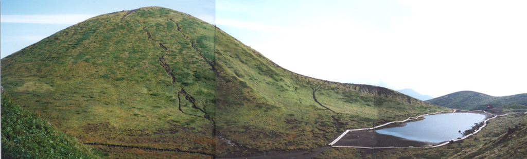
 Onamedake cone and the Amidaike pond are located at the NE end of the summit crater complex of Akita-Komagatake. This cone forms the highest point of the volcano and has produced lava flows to the N and E. This photo is taken from the NE rim of a 1.5 x 3 km caldera partially filled by basaltic cones.