
In late August, fewer than ten earthquakes occurred at Hachijo-jima per hour and ground deformation had returned to normal levels. On 27 August, very long-period signals were detected near Hachijo-jima. The signals were felt widely on the southern coast of Honshu. The hypocenter of a high-frequency earthquake preceded by a very long-period signal was located NW offshore of the volcano.
Source: Japan Meteorological Agency (JMA) via the Volcano Research Center
Seismic swarms during August 2002
The Japanese Meteorological Agency (JMA) reported that at around 1600 on 13 August 2002 seismic swarms began on Hachijo-jima island (figure 1). The island lies ~300 km S of Tokyo in the Izu island chain. A total of 16 earthquakes were felt by 1700 on 15 August. Hypocenters were located ~2 km off the W shore of the central part of the island, at depths of 5-15 km (according to seismic-wave velocity models) (figure 2). The earthquakes deepened and started migrating to the N, in the direction of Nishi-yama, on the morning on 15 August. Five seismic stations are located on the inhabited island.
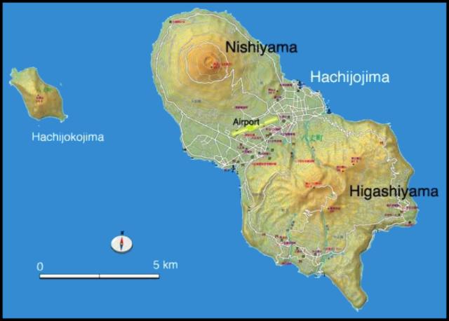 |
Figure 1. Map showing the elongated, NW-SE-trending Hachijo-jima island, consisting of two small Quaternary stratovolcanoes, Higashi-yama to the SE and Nishi-yama to the NW. The small volcanic island of Ko-jima lies several kilometers to the W of Hachijo-jima. Courtesy of Volcano Research Center. |
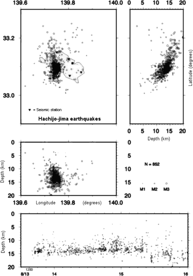 |
Figure 2. Hypocenters of volcanic earthquakes at Hachijo-jima during 13-15 August 2002 (as of 2000 on 15 August). Courtesy of Shin'ichi Sakai, JMA. |
On 16 August JMA reported that high seismicity continued at Hachijo-jima volcano, when volcanic tremor-like waves were recorded. JMA reported that the hourly number of earthquakes had been over 20 since the evening of 13 August; the peak occurred on the morning of 15 August (~250 earthquakes per hour). As of 1500 on 16 August, 22 earthquakes had been felt. Seismic activity began to decrease during the evening of 16 August. JMA reported that during 16-17 August, less than 20 earthquakes occurred per hour. JMA installed two seismometers temporarily on the island on 17 August. JMA released a statement saying that the present seismic activity may continue at the same level for some time without an eruption. The Geographical Survey Institute reported that the GPS station located in the center of the island had migrated 5-6 cm to the E and had been uplifted 10 cm by 1500 on 16 August.
Seismicity around Hachijo-jima decreased by 21 August. Since the afternoon of 20 August, less than 10 earthquakes occurred per hour. Hypocenters had migrated to the NW from the original site of earthquake concentration, advancing parallel to the long axis of the island. Low-frequency earthquakes continued on 21 August; hypocenters were located near the first swarms of 13-15 August.
Information Contacts: Hitoshi Yamasato, Japanese Meteorological Agency (JMA), Volcanological Division, 1-3-4 Ote-machi, Chiyoda-ku, Tokyo 100, Japan (URL: http://www.jma.go.jp/); Shin'ichi Sakai, Volcano Research Center (VRC), Earthquake Research Institute (ERI), University of Tokyo, 113-0032 1-1-1, Yayoi, Bunkyo-ku, Tokyo (URL: http://www.eri.u-tokyo.ac.jp/VRC/index_E.html); Geographical Survey Institute (GSI), Kitasato 1, Tsukuba Ibaraki, 305-0811 Japan (URL: http://www.gsi.go.jp/).
In late August, fewer than ten earthquakes occurred at Hachijo-jima per hour and ground deformation had returned to normal levels. On 27 August, very long-period signals were detected near Hachijo-jima. The signals were felt widely on the southern coast of Honshu. The hypocenter of a high-frequency earthquake preceded by a very long-period signal was located NW offshore of the volcano.
Source: Japan Meteorological Agency (JMA) via the Volcano Research Center
Seismicity that began to increase at Hachijo-jima on 13 August (when 16 earthquakes were recorded) began to decrease on 20 August (less than 10 earthquakes were recorded). The earthquake's hypocenters migrated from NW to SE, roughly parallel to the long axis of the island. Hypocenters of low-frequency earthquakes that occurred on the morning of 21 August were located near the 13-15 August swarm's hypocenters.
Source: Japan Meteorological Agency (JMA) via the Volcano Research Center
JMA reported that seismicity increased at Hachijo-jima beginning on 13 August around 1600. By 1700 that day 16 earthquakes were felt, with a maximum magnitude of 3. The hypocenters were located ~2 km off of the island's W shore at depths of 5-15 km, depending on assumed seismic-wave velocity models. During the afternoon of the 15th, the earthquakes migrated to the N, without a clear change in depth. By the 16th, volcanic tremor-like waveforms were also recorded. By the evening of the 16th seismicity began to decrease. JMA stated that the overall increase in seismicity might not lead directly to an eruption, though seismicity may continue at a similar level. According to the Geographical Survey Institute, GPS measurements revealed in the center of the island there was 5-6 cm of movement to the E and 10 cm of uplift until about 1500.
Source: Japan Meteorological Agency (JMA) via the Volcano Research Center
Reports are organized chronologically and indexed below by Month/Year (Publication Volume:Number), and include a one-line summary. Click on the index link or scroll down to read the reports.
Seismic swarms during August 2002
The Japanese Meteorological Agency (JMA) reported that at around 1600 on 13 August 2002 seismic swarms began on Hachijo-jima island (figure 1). The island lies ~300 km S of Tokyo in the Izu island chain. A total of 16 earthquakes were felt by 1700 on 15 August. Hypocenters were located ~2 km off the W shore of the central part of the island, at depths of 5-15 km (according to seismic-wave velocity models) (figure 2). The earthquakes deepened and started migrating to the N, in the direction of Nishi-yama, on the morning on 15 August. Five seismic stations are located on the inhabited island.
|
Figure 1. Map showing the elongated, NW-SE-trending Hachijo-jima island, consisting of two small Quaternary stratovolcanoes, Higashi-yama to the SE and Nishi-yama to the NW. The small volcanic island of Ko-jima lies several kilometers to the W of Hachijo-jima. Courtesy of Volcano Research Center. |
|
Figure 2. Hypocenters of volcanic earthquakes at Hachijo-jima during 13-15 August 2002 (as of 2000 on 15 August). Courtesy of Shin'ichi Sakai, JMA. |
On 16 August JMA reported that high seismicity continued at Hachijo-jima volcano, when volcanic tremor-like waves were recorded. JMA reported that the hourly number of earthquakes had been over 20 since the evening of 13 August; the peak occurred on the morning of 15 August (~250 earthquakes per hour). As of 1500 on 16 August, 22 earthquakes had been felt. Seismic activity began to decrease during the evening of 16 August. JMA reported that during 16-17 August, less than 20 earthquakes occurred per hour. JMA installed two seismometers temporarily on the island on 17 August. JMA released a statement saying that the present seismic activity may continue at the same level for some time without an eruption. The Geographical Survey Institute reported that the GPS station located in the center of the island had migrated 5-6 cm to the E and had been uplifted 10 cm by 1500 on 16 August.
Seismicity around Hachijo-jima decreased by 21 August. Since the afternoon of 20 August, less than 10 earthquakes occurred per hour. Hypocenters had migrated to the NW from the original site of earthquake concentration, advancing parallel to the long axis of the island. Low-frequency earthquakes continued on 21 August; hypocenters were located near the first swarms of 13-15 August.
Information Contacts: Hitoshi Yamasato, Japanese Meteorological Agency (JMA), Volcanological Division, 1-3-4 Ote-machi, Chiyoda-ku, Tokyo 100, Japan (URL: http://www.jma.go.jp/); Shin'ichi Sakai, Volcano Research Center (VRC), Earthquake Research Institute (ERI), University of Tokyo, 113-0032 1-1-1, Yayoi, Bunkyo-ku, Tokyo (URL: http://www.eri.u-tokyo.ac.jp/VRC/index_E.html); Geographical Survey Institute (GSI), Kitasato 1, Tsukuba Ibaraki, 305-0811 Japan (URL: http://www.gsi.go.jp/).
|
|
||||||||||||||||||||||||||
There is data available for 18 confirmed Holocene eruptive periods.
[ 1707 ] Uncertain Eruption
| Episode 1 | Eruption (Explosive / Effusive) | ||||||||||||||||||||
|---|---|---|---|---|---|---|---|---|---|---|---|---|---|---|---|---|---|---|---|---|
| 1707 - Unknown | Evidence from Unknown | |||||||||||||||||||
|
List of 2 Events for Episode 1
|
||||||||||||||||||||
1606 Jan 23 Confirmed Eruption (Explosive / Effusive) VEI: 2
| Episode 1 | Eruption (Explosive / Effusive) | Submarine flank | ||||||||||||||||||||||||
|---|---|---|---|---|---|---|---|---|---|---|---|---|---|---|---|---|---|---|---|---|---|---|---|---|---|
| 1606 Jan 23 - Unknown | Evidence from Observations: Reported | ||||||||||||||||||||||||
|
List of 3 Events for Episode 1 at Submarine flank
|
|||||||||||||||||||||||||
1605 Oct 27 Confirmed Eruption (Explosive / Effusive) VEI: 2
| Episode 1 | Eruption (Explosive / Effusive) | Nishi-yama SE flank | |||||||||||||||||||||||||||||
|---|---|---|---|---|---|---|---|---|---|---|---|---|---|---|---|---|---|---|---|---|---|---|---|---|---|---|---|---|---|---|
| 1605 Oct 27 - Unknown | Evidence from Observations: Reported | |||||||||||||||||||||||||||||
|
List of 4 Events for Episode 1 at Nishi-yama SE flank
|
||||||||||||||||||||||||||||||
1518 Feb - 1523 Confirmed Eruption (Explosive / Effusive) VEI: 2
| Episode 1 | Eruption (Explosive / Effusive) | Nishi-yama | |||||||||||||||||||
|---|---|---|---|---|---|---|---|---|---|---|---|---|---|---|---|---|---|---|---|---|
| 1518 Feb - 1523 | Evidence from Observations: Reported | |||||||||||||||||||
|
List of 2 Events for Episode 1 at Nishi-yama
|
||||||||||||||||||||
1487 Dec 7 Confirmed Eruption (Explosive / Effusive) VEI: 2
| Episode 1 | Eruption (Explosive / Effusive) | Nishi-yama | |||||||||||||||||||
|---|---|---|---|---|---|---|---|---|---|---|---|---|---|---|---|---|---|---|---|---|
| 1487 Dec 7 - Unknown | Evidence from Observations: Reported | |||||||||||||||||||
|
List of 2 Events for Episode 1 at Nishi-yama
|
||||||||||||||||||||
0850 ± 200 years Confirmed Eruption (Explosive / Effusive)
| Episode 1 | Eruption (Explosive / Effusive) | Nishi-yama summit and SE flank | ||||||||||||||||||||||||
|---|---|---|---|---|---|---|---|---|---|---|---|---|---|---|---|---|---|---|---|---|---|---|---|---|---|
| 0850 ± 200 years - Unknown | Evidence from Isotopic: 14C (calibrated) | ||||||||||||||||||||||||
|
List of 3 Events for Episode 1 at Nishi-yama summit and SE flank
|
|||||||||||||||||||||||||
0150 BCE ± 50 years Confirmed Eruption (Explosive / Effusive)
| Episode 1 | Eruption (Explosive / Effusive) | Nishi-yama | |||||||||||||||||||
|---|---|---|---|---|---|---|---|---|---|---|---|---|---|---|---|---|---|---|---|---|
| 0150 BCE ± 50 years - Unknown | Evidence from Isotopic: 14C (calibrated) | |||||||||||||||||||
|
List of 2 Events for Episode 1 at Nishi-yama
|
||||||||||||||||||||
0350 BCE ± 500 years Confirmed Eruption (Explosive / Effusive) VEI: 3
| Episode 1 | Eruption (Explosive / Effusive) | NW flank of Higashi-yama | |||||||||||||||||||||||||||||
|---|---|---|---|---|---|---|---|---|---|---|---|---|---|---|---|---|---|---|---|---|---|---|---|---|---|---|---|---|---|---|
| 0350 BCE ± 500 years - Unknown | Evidence from Correlation: Tephrochronology | |||||||||||||||||||||||||||||
|
List of 4 Events for Episode 1 at NW flank of Higashi-yama
|
||||||||||||||||||||||||||||||
1150 BCE ± 700 years Confirmed Eruption (Explosive / Effusive)
| Episode 1 | Eruption (Explosive / Effusive) | SE flank of Nishi-yama (Kanda-yama) | ||||||||||||||||||||||||
|---|---|---|---|---|---|---|---|---|---|---|---|---|---|---|---|---|---|---|---|---|---|---|---|---|---|
| 1150 BCE ± 700 years - Unknown | Evidence from Correlation: Tephrochronology | ||||||||||||||||||||||||
|
List of 3 Events for Episode 1 at SE flank of Nishi-yama (Kanda-yama)
|
|||||||||||||||||||||||||
1250 BCE ± 800 years Confirmed Eruption (Explosive / Effusive)
| Episode 1 | Eruption (Explosive / Effusive) | Nishi-yama | |||||||||||||||||||
|---|---|---|---|---|---|---|---|---|---|---|---|---|---|---|---|---|---|---|---|---|
| 1250 BCE ± 800 years - Unknown | Evidence from Correlation: Tephrochronology | |||||||||||||||||||
|
List of 2 Events for Episode 1 at Nishi-yama
|
||||||||||||||||||||
2050 BCE (?) Confirmed Eruption (Explosive / Effusive) VEI: 5
| Episode 1 | Eruption (Explosive / Effusive) | SE of Nishi-yama, NE of Higashi-yama | |||||||||||||||||||||||||||||
|---|---|---|---|---|---|---|---|---|---|---|---|---|---|---|---|---|---|---|---|---|---|---|---|---|---|---|---|---|---|---|
| 2050 BCE (?) - Unknown | Evidence from Correlation: Tephrochronology | |||||||||||||||||||||||||||||
|
List of 4 Events for Episode 1 at SE of Nishi-yama, NE of Higashi-yama
|
||||||||||||||||||||||||||||||
2450 BCE ± 500 years Confirmed Eruption (Explosive / Effusive) VEI: 4
| Episode 1 | Eruption (Explosive / Effusive) | Nishi-yama | ||||||||||||||||||||||||||||||||||
|---|---|---|---|---|---|---|---|---|---|---|---|---|---|---|---|---|---|---|---|---|---|---|---|---|---|---|---|---|---|---|---|---|---|---|---|
| 2450 BCE ± 500 years - Unknown | Evidence from Correlation: Tephrochronology | ||||||||||||||||||||||||||||||||||
|
List of 5 Events for Episode 1 at Nishi-yama
|
|||||||||||||||||||||||||||||||||||
2550 BCE ± 500 years Confirmed Eruption (Explosive / Effusive) VEI: 3
| Episode 1 | Eruption (Explosive / Effusive) | S flank of Higashi-yama (Myohoji) | ||||||||||||||||||||||||
|---|---|---|---|---|---|---|---|---|---|---|---|---|---|---|---|---|---|---|---|---|---|---|---|---|---|
| 2550 BCE ± 500 years - Unknown | Evidence from Correlation: Tephrochronology | ||||||||||||||||||||||||
|
List of 3 Events for Episode 1 at S flank of Higashi-yama (Myohoji)
|
|||||||||||||||||||||||||
2700 BCE ± 100 years Confirmed Eruption (Explosive / Effusive) VEI: 3
| Episode 1 | Eruption (Explosive / Effusive) | Between Nishi-yama & Higashi-yama | |||||||||||||||||||||||||||||
|---|---|---|---|---|---|---|---|---|---|---|---|---|---|---|---|---|---|---|---|---|---|---|---|---|---|---|---|---|---|---|
| 2700 BCE ± 100 years - Unknown | Evidence from Isotopic: 14C (calibrated) | |||||||||||||||||||||||||||||
|
List of 4 Events for Episode 1 at Between Nishi-yama & Higashi-yama
|
||||||||||||||||||||||||||||||
3350 BCE ± 1300 years Confirmed Eruption (Explosive / Effusive)
| Episode 1 | Eruption (Explosive / Effusive) | Nishi-yama | |||||||||||||||||||
|---|---|---|---|---|---|---|---|---|---|---|---|---|---|---|---|---|---|---|---|---|
| 3350 BCE ± 1300 years - Unknown | Evidence from Correlation: Tephrochronology | |||||||||||||||||||
|
List of 2 Events for Episode 1 at Nishi-yama
|
||||||||||||||||||||
4650 BCE (?) Confirmed Eruption (Explosive / Effusive) VEI: 5
| Episode 1 | Eruption (Explosive / Effusive) | Nishi-yama | ||||||||||||||||||||||||||||||||||
|---|---|---|---|---|---|---|---|---|---|---|---|---|---|---|---|---|---|---|---|---|---|---|---|---|---|---|---|---|---|---|---|---|---|---|---|
| 4650 BCE (?) - Unknown | Evidence from Correlation: Tephrochronology | ||||||||||||||||||||||||||||||||||
|
List of 5 Events for Episode 1 at Nishi-yama
|
|||||||||||||||||||||||||||||||||||
5020 BCE ± 370 years Confirmed Eruption (Explosive / Effusive) VEI: 3
| Episode 1 | Eruption (Explosive / Effusive) | Higashi-yama south flank | |||||||||||||||||||||||||||||
|---|---|---|---|---|---|---|---|---|---|---|---|---|---|---|---|---|---|---|---|---|---|---|---|---|---|---|---|---|---|---|
| 5020 BCE ± 370 years - Unknown | Evidence from Correlation: Tephrochronology | |||||||||||||||||||||||||||||
|
List of 4 Events for Episode 1 at Higashi-yama south flank
|
||||||||||||||||||||||||||||||
7650 BCE ± 3000 years Confirmed Eruption (Explosive / Effusive)
| Episode 1 | Eruption (Explosive / Effusive) | Nishi-yama | |||||||||||||||||||
|---|---|---|---|---|---|---|---|---|---|---|---|---|---|---|---|---|---|---|---|---|
| 7650 BCE ± 3000 years - Unknown | Evidence from Correlation: Tephrochronology | |||||||||||||||||||
|
List of 2 Events for Episode 1 at Nishi-yama
|
||||||||||||||||||||
8020 BCE ± 2640 years Confirmed Eruption (Explosive / Effusive) VEI: 4
| Episode 1 | Eruption (Explosive / Effusive) | Nishi-yama | |||||||||||||||||||||||||||||
|---|---|---|---|---|---|---|---|---|---|---|---|---|---|---|---|---|---|---|---|---|---|---|---|---|---|---|---|---|---|---|
| 8020 BCE ± 2640 years - Unknown | Evidence from Correlation: Tephrochronology | |||||||||||||||||||||||||||||
|
List of 4 Events for Episode 1 at Nishi-yama
|
||||||||||||||||||||||||||||||
This compilation of synonyms and subsidiary features may not be comprehensive. Features are organized into four major categories: Cones, Craters, Domes, and Thermal Features. Synonyms of features appear indented below the primary name. In some cases additional feature type, elevation, or location details are provided.
Synonyms |
||||
| Hachijo-jima Nishi-yama | Hatizyo-zima Nisi-yama | Hatizyo-Huzi | Hachijo-Fuji | Hachijo-jima | ||||
Cones |
||||
| Feature Name | Feature Type | Elevation | Latitude | Longitude |
| Hachiman-yama | Cone | 225 m | 33° 4' 0.00" N | 139° 48' 0.00" E |
| Higashi-hakuunzan | Cone | 608 m | 33° 6' 0.00" N | 139° 50' 0.00" E |
| Higashi-yama
Higasi-yama |
Stratovolcano | 701 m | 33° 5' 0.00" N | 139° 49' 0.00" E |
| Ko-jima
Ko-zima |
Stratovolcano | 617 m | 33° 8' 0.00" N | 139° 42' 0.00" E |
| Myohoji | Cone | 33° 4' 0.00" N | 139° 49' 0.00" E | |
| Nakanogo | Cone | 33° 4' 0.00" N | 139° 49' 0.00" E | |
| Nishi-yama
Nisi-yama |
Stratovolcano | 854 m | 33° 8' 0.00" N | 139° 46' 0.00" E |
Craters |
||||
| Feature Name | Feature Type | Elevation | Latitude | Longitude |
| Kando-yama | Crater | 195 m | 33° 7' 0.00" N | 139° 48' 0.00" E |
| Mihara | Pleistocene caldera | 701 m | 33° 5' 0.00" N | 139° 49' 0.00" E |
| Nishi-Hakuunzan | Pleistocene caldera | 635 m | 33° 5' 0.00" N | 139° 49' 0.00" E |
| Oana | Crater | 854 m | 33° 8' 0.00" N | 139° 46' 0.00" E |
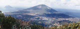 Nishiyama volcano, seen here from the older Higashiyama, forms the NW part of Hachijojima island. The island's airport and its largest town occupy the flanks. The small volcanic island of Kojima (upper left) lies several kilometers to the west. Major activity from the early Holocene until about 4,000 years ago was restricted to flank eruptions.
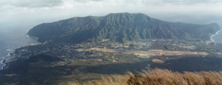 Higashiyama is the oldest of two volcanoes forming Hachijojima at the SE part of the island. Activity at Higashiyama, seen here from the slopes of Nishiyama, dates back to the Pleistocene. An eruption around 4,000 years ago deposited the Mizumiya pumice fall deposit.
There are no samples for Hachijojima in the Smithsonian's NMNH Department of Mineral Sciences Rock and Ore collection.
| Copernicus Browser | The Copernicus Browser replaced the Sentinel Hub Playground browser in 2023, to provide access to Earth observation archives from the Copernicus Data Space Ecosystem, the main distribution platform for data from the EU Copernicus missions. |
| MIROVA | Middle InfraRed Observation of Volcanic Activity (MIROVA) is a near real time volcanic hot-spot detection system based on the analysis of MODIS (Moderate Resolution Imaging Spectroradiometer) data. In particular, MIROVA uses the Middle InfraRed Radiation (MIR), measured over target volcanoes, in order to detect, locate and measure the heat radiation sourced from volcanic activity. |
| MODVOLC Thermal Alerts | Using infrared satellite Moderate Resolution Imaging Spectroradiometer (MODIS) data, scientists at the Hawai'i Institute of Geophysics and Planetology, University of Hawai'i, developed an automated system called MODVOLC to map thermal hot-spots in near real time. For each MODIS image, the algorithm automatically scans each 1 km pixel within it to check for high-temperature hot-spots. When one is found the date, time, location, and intensity are recorded. MODIS looks at every square km of the Earth every 48 hours, once during the day and once during the night, and the presence of two MODIS sensors in space allows at least four hot-spot observations every two days. Each day updated global maps are compiled to display the locations of all hot spots detected in the previous 24 hours. There is a drop-down list with volcano names which allow users to 'zoom-in' and examine the distribution of hot-spots at a variety of spatial scales. |
|
WOVOdat
Single Volcano View Temporal Evolution of Unrest Side by Side Volcanoes |
WOVOdat is a database of volcanic unrest; instrumentally and visually recorded changes in seismicity, ground deformation, gas emission, and other parameters from their normal baselines. It is sponsored by the World Organization of Volcano Observatories (WOVO) and presently hosted at the Earth Observatory of Singapore.
GVMID Data on Volcano Monitoring Infrastructure The Global Volcano Monitoring Infrastructure Database GVMID, is aimed at documenting and improving capabilities of volcano monitoring from the ground and space. GVMID should provide a snapshot and baseline view of the techniques and instrumentation that are in place at various volcanoes, which can be use by volcano observatories as reference to setup new monitoring system or improving networks at a specific volcano. These data will allow identification of what monitoring gaps exist, which can be then targeted by remote sensing infrastructure and future instrument deployments. |
| Volcanic Hazard Maps | The IAVCEI Commission on Volcanic Hazards and Risk has a Volcanic Hazard Maps database designed to serve as a resource for hazard mappers (or other interested parties) to explore how common issues in hazard map development have been addressed at different volcanoes, in different countries, for different hazards, and for different intended audiences. In addition to the comprehensive, searchable Volcanic Hazard Maps Database, this website contains information about diversity of volcanic hazard maps, illustrated using examples from the database. This site is for educational purposes related to volcanic hazard maps. Hazard maps found on this website should not be used for emergency purposes. For the most recent, official hazard map for a particular volcano, please seek out the proper institutional authorities on the matter. |
| IRIS seismic stations/networks | Incorporated Research Institutions for Seismology (IRIS) Data Services map showing the location of seismic stations from all available networks (permanent or temporary) within a radius of 0.18° (about 20 km at mid-latitudes) from the given location of Hachijojima. Users can customize a variety of filters and options in the left panel. Note that if there are no stations are known the map will default to show the entire world with a "No data matched request" error notice. |
| UNAVCO GPS/GNSS stations | Geodetic Data Services map from UNAVCO showing the location of GPS/GNSS stations from all available networks (permanent or temporary) within a radius of 20 km from the given location of Hachijojima. Users can customize the data search based on station or network names, location, and time window. Requires Adobe Flash Player. |
| DECADE Data | The DECADE portal, still in the developmental stage, serves as an example of the proposed interoperability between The Smithsonian Institution's Global Volcanism Program, the Mapping Gas Emissions (MaGa) Database, and the EarthChem Geochemical Portal. The Deep Earth Carbon Degassing (DECADE) initiative seeks to use new and established technologies to determine accurate global fluxes of volcanic CO2 to the atmosphere, but installing CO2 monitoring networks on 20 of the world's 150 most actively degassing volcanoes. The group uses related laboratory-based studies (direct gas sampling and analysis, melt inclusions) to provide new data for direct degassing of deep earth carbon to the atmosphere. |
| Large Eruptions of Hachijojima | Information about large Quaternary eruptions (VEI >= 4) is cataloged in the Large Magnitude Explosive Volcanic Eruptions (LaMEVE) database of the Volcano Global Risk Identification and Analysis Project (VOGRIPA). |
| EarthChem | EarthChem develops and maintains databases, software, and services that support the preservation, discovery, access and analysis of geochemical data, and facilitate their integration with the broad array of other available earth science parameters. EarthChem is operated by a joint team of disciplinary scientists, data scientists, data managers and information technology developers who are part of the NSF-funded data facility Integrated Earth Data Applications (IEDA). IEDA is a collaborative effort of EarthChem and the Marine Geoscience Data System (MGDS). |

