
| Country | Japan |
| Volcanic Region | Northeast Japan Volcanic Arc |
| Landform | Volc Type | Composite | Stratovolcano(es) |
| Last Known Eruption | 4900 BCE |
| Coordinates | 42.875°N, 140.659°E |
| Elevation | 1,308 m (4,291 ft) |
| Volcano Number | 285031 |
 Google Earth Placemark with Features Google Earth Placemark with Features
| |
 Cite Volcano Profile Cite Volcano Profile
| |
The Global Volcanism Program has no Weekly Volcanic Activity Reports available for Niseko.
The Global Volcanism Program has no Bulletin Reports available for Niseko.
The Global Volcanism Program has no Weekly Reports available for Niseko.
The Global Volcanism Program has no Bulletin Reports available for Niseko.
|
|
||||||||||||||||||||||||||
There is data available for 1 confirmed eruptive period.
4900 BCE (?) Confirmed Eruption (Explosive / Effusive)
| Episode 1 | Eruption (Explosive / Effusive) | ||||||||||||||||||||||||
|---|---|---|---|---|---|---|---|---|---|---|---|---|---|---|---|---|---|---|---|---|---|---|---|---|
| 4900 BCE (?) - Unknown | Evidence from Correlation: Tephrochronology | |||||||||||||||||||||||
|
List of 3 Events for Episode 1
|
||||||||||||||||||||||||
This compilation of synonyms and subsidiary features may not be comprehensive. Features are organized into four major categories: Cones, Craters, Domes, and Thermal Features. Synonyms of features appear indented below the primary name. In some cases additional feature type, elevation, or location details are provided.
Cones |
||||
| Feature Name | Feature Type | Elevation | Latitude | Longitude |
| Chakunage | Cone | |||
| Mekuninai | Cone | |||
| Raiden | Cone | |||
| Waishuhorun | Cone | |||
Domes |
||||
| Feature Name | Feature Type | Elevation | Latitude | Longitude |
| Chisenupuri | Dome | |||
| Iwaonupuri | Dome | 1116 m | 42° 53' 7.00" N | 140° 38' 26.00" E |
| Niseko-Annupuri | Dome | 1308 m | 42° 52' 30.00" N | 140° 39' 32.00" E |
| Nitonupuri | Dome | |||
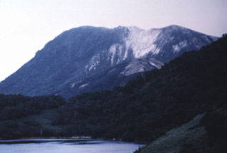 Onuma lake in the foreground is surrounded by Iwaonupuri (background), Nitonupuri, and Waisuhorun volcanoes. The latter two are located on the NW slope of Iwaonupuri. The younger lava dome (to the left) of Iwaonupuri overlies the older dome to the right. The contact is at the white altered area in the right-center. The eastern slope of Nitonupuri lava dome is seen at the right foreground.
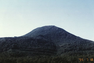 Chisenupuri volcano, seen here from the SE, is a lava dome that overlies the massive lava flow to the left. It is part of the Niseko volcano group, a cluster of small cones and lava domes.
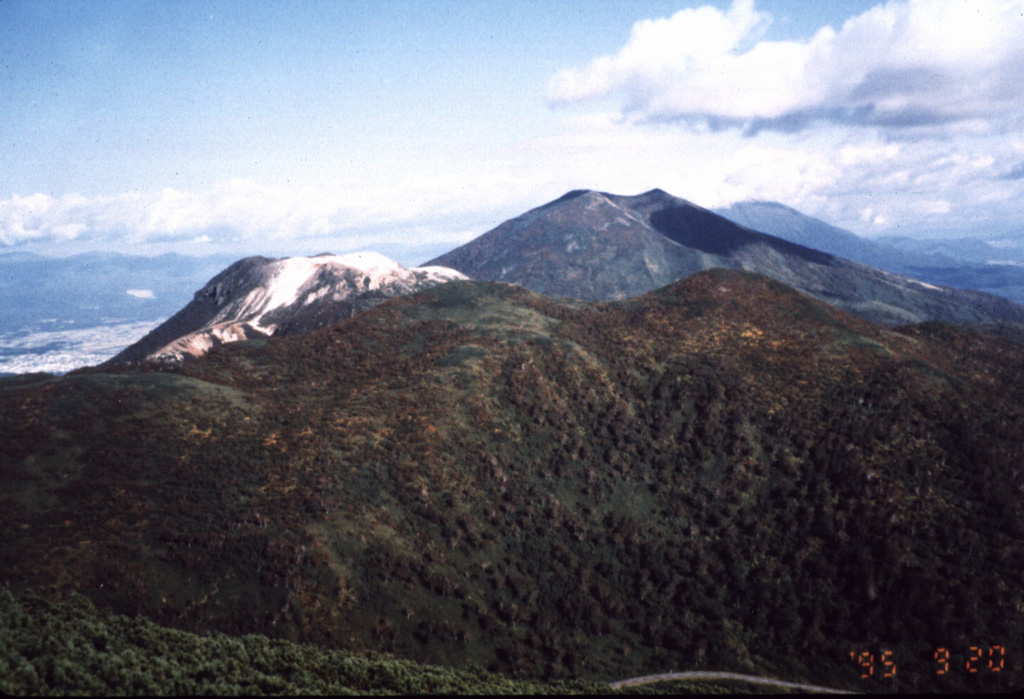
 Several peaks of the Niseko volcano complex are seen in this view looking W from the Chisenupuri summit. From front to back are the forested Nitonupuri, light-colored, flat-topped Iwaonupuri, and Niseko-Annupuri. Yotei volcano is visible in the distance to the right of Niseko-Annupuri.
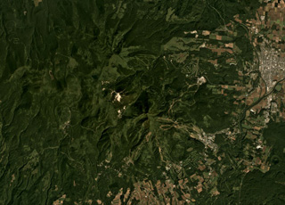 The Niseko complex is shown in this September 2019 Planet Labs satellite image monthly mosaic (N is at the top; this image is approximately 18 km across). The complex contains multiple cones and lava domes including Chisenupuri, Iwaonupuri (the light area near the image center), Niseko-Annupuri, and Nitonupuri domes. The small crater near the lower right corner is Hangetsu-ko of Yoteizan volcano.
There are no samples for Niseko in the Smithsonian's NMNH Department of Mineral Sciences Rock and Ore collection.
| Copernicus Browser | The Copernicus Browser replaced the Sentinel Hub Playground browser in 2023, to provide access to Earth observation archives from the Copernicus Data Space Ecosystem, the main distribution platform for data from the EU Copernicus missions. |
| MIROVA | Middle InfraRed Observation of Volcanic Activity (MIROVA) is a near real time volcanic hot-spot detection system based on the analysis of MODIS (Moderate Resolution Imaging Spectroradiometer) data. In particular, MIROVA uses the Middle InfraRed Radiation (MIR), measured over target volcanoes, in order to detect, locate and measure the heat radiation sourced from volcanic activity. |
| MODVOLC Thermal Alerts | Using infrared satellite Moderate Resolution Imaging Spectroradiometer (MODIS) data, scientists at the Hawai'i Institute of Geophysics and Planetology, University of Hawai'i, developed an automated system called MODVOLC to map thermal hot-spots in near real time. For each MODIS image, the algorithm automatically scans each 1 km pixel within it to check for high-temperature hot-spots. When one is found the date, time, location, and intensity are recorded. MODIS looks at every square km of the Earth every 48 hours, once during the day and once during the night, and the presence of two MODIS sensors in space allows at least four hot-spot observations every two days. Each day updated global maps are compiled to display the locations of all hot spots detected in the previous 24 hours. There is a drop-down list with volcano names which allow users to 'zoom-in' and examine the distribution of hot-spots at a variety of spatial scales. |
|
WOVOdat
Single Volcano View Temporal Evolution of Unrest Side by Side Volcanoes |
WOVOdat is a database of volcanic unrest; instrumentally and visually recorded changes in seismicity, ground deformation, gas emission, and other parameters from their normal baselines. It is sponsored by the World Organization of Volcano Observatories (WOVO) and presently hosted at the Earth Observatory of Singapore.
GVMID Data on Volcano Monitoring Infrastructure The Global Volcano Monitoring Infrastructure Database GVMID, is aimed at documenting and improving capabilities of volcano monitoring from the ground and space. GVMID should provide a snapshot and baseline view of the techniques and instrumentation that are in place at various volcanoes, which can be use by volcano observatories as reference to setup new monitoring system or improving networks at a specific volcano. These data will allow identification of what monitoring gaps exist, which can be then targeted by remote sensing infrastructure and future instrument deployments. |
| Volcanic Hazard Maps | The IAVCEI Commission on Volcanic Hazards and Risk has a Volcanic Hazard Maps database designed to serve as a resource for hazard mappers (or other interested parties) to explore how common issues in hazard map development have been addressed at different volcanoes, in different countries, for different hazards, and for different intended audiences. In addition to the comprehensive, searchable Volcanic Hazard Maps Database, this website contains information about diversity of volcanic hazard maps, illustrated using examples from the database. This site is for educational purposes related to volcanic hazard maps. Hazard maps found on this website should not be used for emergency purposes. For the most recent, official hazard map for a particular volcano, please seek out the proper institutional authorities on the matter. |
| EarthScope Consortium SAGE seismic stations/networks | EarthScope Consortium operates the NSF Geodetic Facility for the Advancement of Geoscience (GAGE) and NSF Seismological Facility for the Advancement of Geoscience (SAGE). The linked map shows the location of seismic stations from all available networks (permanent or temporary) within a radius of 0.18° (about 20 km at mid-latitudes) from the given location of Niseko. Users can customize a variety of filters and options in the left panel. Note that if there are no stations are known the map will default to show the entire world with a "No data matched request" error notice. |
| Large Eruptions of Niseko | Information about large Quaternary eruptions (VEI >= 4) is cataloged in the Large Magnitude Explosive Volcanic Eruptions (LaMEVE) database of the Volcano Global Risk Identification and Analysis Project (VOGRIPA). |
| EarthChem | EarthChem develops and maintains databases, software, and services that support the preservation, discovery, access and analysis of geochemical data, and facilitate their integration with the broad array of other available earth science parameters. EarthChem is operated by a joint team of disciplinary scientists, data scientists, data managers and information technology developers who are part of the NSF-funded data facility Integrated Earth Data Applications (IEDA). IEDA is a collaborative effort of EarthChem and the Marine Geoscience Data System (MGDS). |

