
SVERT and KVERT reported that during 25 June-1 July steam-and-gas plumes with ash rose 1.5-2 km above Raikoke and drifted WNW based on satellite images. The Aviation Color Code was lowered to Yellow on 25 June and then to Green on 27 June.
Sources: Sakhalin Volcanic Eruption Response Team (SVERT), Kamchatkan Volcanic Eruption Response Team (KVERT)
Short-lived series of large explosions 21-23 June 2019; first recorded activity in 95 years
Raikoke in the central Kuril Islands lies 400 km SW of the southern tip of Russia's Kamchatcka Peninsula. Two significant eruptive events in historical times, including fatalities, have been recorded. In 1778 an eruption killed 15 people "under the hail of bombs" who were under the command of Captain Chernyi, returning from Matua to Kamchatka. This prompted the Russian military to order the first investigation of the volcanic character of the island two years later (Gorshkov, 1970). Tanakadate (1925) reported that travelers on a steamer witnessed an ash plume rising from the island on 15 February 1924, observed that the island was already covered in ash from recent activity, and noted that a dense steam plume was visible for a week rising from the summit crater. The latest eruptive event in June 2019 produced a very large ash plume that covered the island with ash and dispersed ash and gases more than 10 km high into the atmosphere. The volcano is monitored by the Sakhalin Volcanic Eruption Response Team, (SVERT) part of the Institute of Marine Geology and Geophysics, Far Eastern Branch of the Russian Academy of Sciences (IMGG FEB RAS) and the Kamchatka Volcanic Eruption Response Team (KVERT) which is part of the Institute of Volcanology and Seismology, Far Eastern Branch of the Russian Academy of Sciences (IVS FEB RAS).
A brief but intense eruption beginning on 21 June 2019 sent major ash and sulfur dioxide plumes into the stratosphere (figures 1 and 2); the plumes rapidly drifted over 1,000 km from the volcano. Strong explosions with dense ash plumes lasted for less than 48 hours, minor emissions continued for a few more days; the SO2, however, continued to circulate over far eastern Russia and the Bering Sea for more than three weeks after the initial explosion. The eruption covered the island with centimeters to meters of ash and enlarged the summit crater. By the end of July 2019 only minor intermittent steam emissions were observed in satellite imagery.
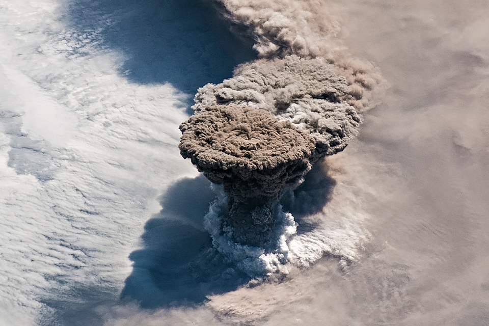 |
Figure 1. On the morning of 22 June 2019, astronauts on the International Space Station captured this image of a large ash plume rising from Raikoke in the Kuril Islands. The plume reached altitudes of 10-13 km and drifted E during the volcano's first known explosion in 95 years. Courtesy of NASA Earth Observatory. |
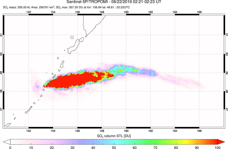 |
Figure 2. A large and very dense SO2 plume (measuring over 900 Dobson Units (DU)) drifted E from Raikoke in the Kuril Islands on 22 June 2019, about 8 hours after the first known explosion in 95 years. Courtesy of NASA Goddard Space Flight Center. |
Summary of 2019 activity. A powerful eruption at Raikoke began at 1805 on 21 June 2019 (UTC). Volcano Observatory Notices for Aviation (VONA's) issued by KVERT described the large ash plume that rapidly rose to 10-13 km altitude and extended for 370 km NE within the first two hours (figure 3). After eight hours, the plume extended 605 km ENE; it had reached 1,160 km E by 13 hours after the first explosion (figure 4). The last strong explosive event, according to KVERT, producing an ash column as high as 10-11 km, occurred at 0540 UTC on 22 June. SVERT reported a series of nine explosions during the eruption. Over 440 lightning events within the ash plume were detected in the first 24 hours by weather-monitoring equipment. The Japanese Ministry of Transportation reported that almost 40 planes were diverted because of the ash plume (figure 5).
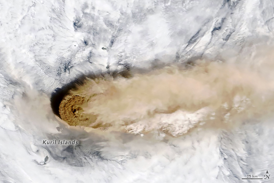 |
Figure 3. A dense ash plume drifted E from Raikoke on 22 June 2019 from a series of large explosions that lasted for less than 24 hours, as seen in this Terra satellite image. The plume was detected in the atmosphere for several days after the end of the eruptive activity. Courtesy of NASA Earth Observatory. |
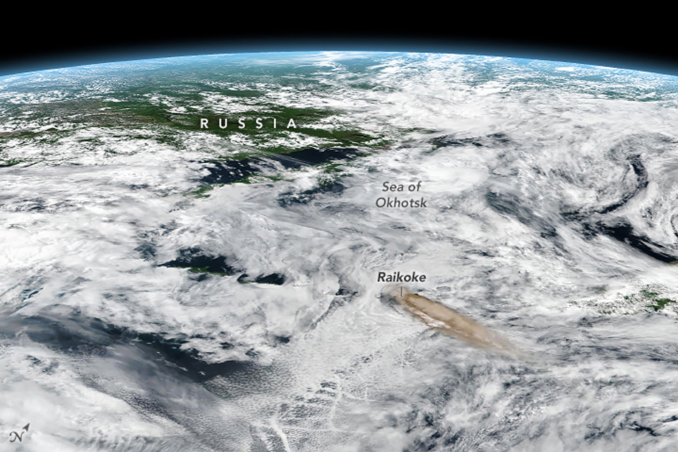 |
Figure 4. The ash plume from Raikoke volcano that erupted on 21 June 2019 drifted over 1,000 km E by late in the day on 22 June, as seen in this oblique, composite view based on data from the Visible Infrared Imaging Radiometer Suite (VIIRS) on the Suomi NPP satellite. Courtesy of NASA Earth Observatory. |
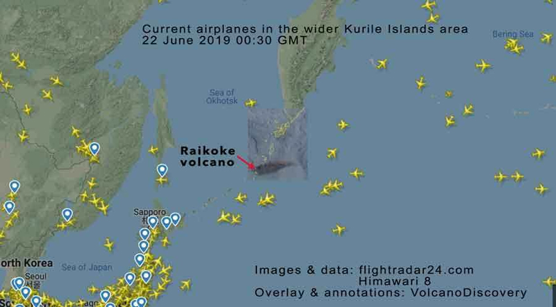 |
Figure 5. Numerous airplanes were traveling on flight paths near the Raikoke ash plume (black streak at center) early on 22 June 2019. The Japanese Ministry of Transportation reported that almost 40 planes were diverted because of the plume. Courtesy of Flightradar24 and Volcano Discovery. |
On 23 June (local time) the cruise ship Athena approached the island; expedition member Nikolai Pavlov provided an eyewitness account and took remarkable drone photographs of the end of the eruption. The ship approached the W flank of the island in the late afternoon and they were able to launch a drone and photograph the shore and the summit. They noted that the entire surface of the island was covered with a thick layer of light-colored ash up to several tens of centimeters thick (figure 6). Fresh debris up to several meters thick fanned out from the base of the slopes (figure 7). The water had a yellowish-greenish tint and was darker brown closer to the shore. Dark-brown steam explosions occurred when waves flowed over hot areas along the shoreline, now blanketed in pale ash with bands of steam and gas rising from it (figure 8). A dense brown ash plume drifted W from the crater, rising about 1.5 km above the summit (figure 9).
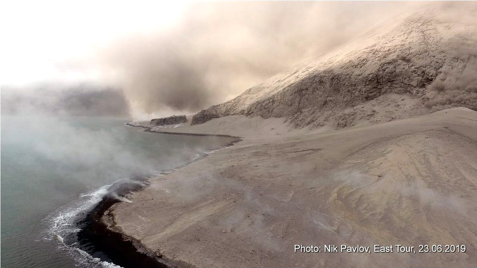 |
Figure 6. The entire surface of the island of Raikoke was covered with a thick layer of light-colored ash up to several tens of centimeters thick on 23 June 2019 when photographed by drone from the cruise ship Athena about 36 hours after the explosions began. View is of the W flank. Photo by Nik Pavlov; courtesy of IVS FEB RAS. |
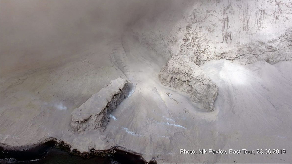 |
Figure 7. Fresh ash and volcanic debris up to several meters thick coated the flanks of Raikoke on 23 June 2019 after the large explosive eruption two days earlier. View is by drone of the W flank. Photo by Nik Pavlov; courtesy of IVS FEB RAS. |
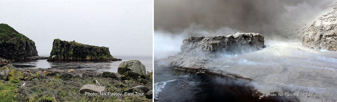 |
Figure 8. The 21 June 2019 eruption of Raikoke covered the island in volcanic debris. The formerly vegetated areas (left, before eruption) were blanketed in pale ash with bands of steam and gas rising all along the shoreline (right, on 23 June 2019) less than two days after the explosions began. The open water area between the sea stack and the island was filled with tephra. Photos by Nik Pavlov; courtesy of IVS FEB RAS. |
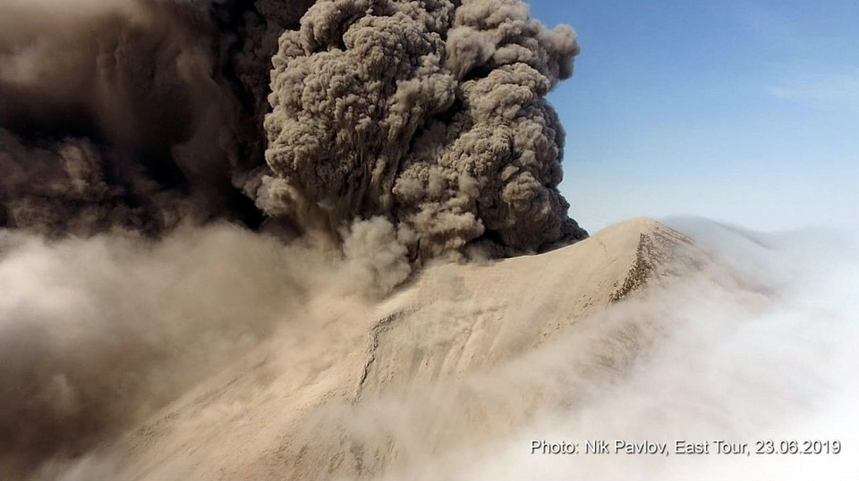 |
Figure 9. At the summit of Raikoke on 23 June 2019, a dense brown ash plume drifted W from the crater, rising about 1.5 km, two days after a large explosive eruption. Drone photo by Nik Pavlov; courtesy of IVS FEB RAS. |
Early on 23 June, the large ash cloud continued to drift E and then NE at an altitude of 10-13 km. At that altitude, the leading edge of the ash cloud became entrained in a large low pressure system and began rotating from SE to NW, centered in the area of the Komandorskiye Islands, 1,200 km NE of Raikoke. By then the farthest edge of ash plume was located about 2,000 km ENE of the volcano. Meanwhile, at the summit and immediately above, the ash plume was drifting NW on 23 June (figures 9 and 10). Ashfall was reported (via Twitter) from a ship in the Pacific Ocean 40 km from Raikoke on 23 June. Weak ashfall was also reported in Paramushir, over 300 km NE the same day. KVERT reported that satellite data from 25 June indicated that a steam and gas plume, possibly with some ash, extended for 60 km NW. They also noted that the high-altitude "aerosol cloud" continued to drift to the N and W, reaching a distance of 1,700 km NW (see SO2 discussion below). By 27 June KVERT reported that the eruption had ended, but the aerosols continued to drift to the NW and E. They lowered the Aviation Alert Level to Green the following day.
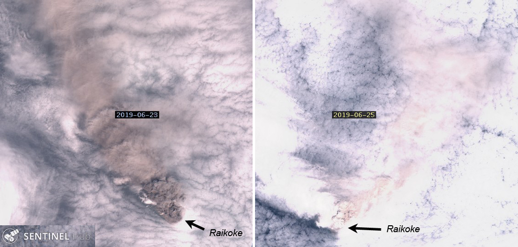 |
Figure 10. The brown ash plume from Raikoke was drifting NW on 23 June 2019 (left), while the remnants of the ash from the earlier explosions continued to be observed over a large area to the NE on 25 June (right). The plume in the 23 June image extends about 30 km NW; the plume in the 25 June image extends a similar distance NE. Natural color rendering (bands 4, 3, 2) of Sentinel-2 imagery, courtesy of Sentinel Hub Playground. |
Tokyo and Anchorage VAAC Reports. The Tokyo VAAC first observed the ash plume in satellite imagery at 10.4 km altitude at 1850 on 21 June 209, just under an hour after the explosion was first reported by KVERT. About four hours later they updated the altitude to 13.1 km based on satellite data and a pilot report. By the evening of 22 June the high-level ash plume was still drifting ESE at about 13 km altitude while a secondary plume at 4.6 km altitude drifted SE for a few more hours before dissipating. The direction of the high-altitude plume began to shift to the NNW by 0300 on 23 June. By 0900 it had dropped slightly to 12.2 km and was drifting NE. The Anchorage VAAC reported at 2030 that the ash plume was becoming obscured by meteorological clouds around a large and deep low-pressure system in the western Bering Sea. Ash and SO2 signals in satellite imagery remained strong over the region S and W of the Pribilof Islands as well as over the far western Bering Sea adjacent to Russia. By early on 24 June the plume drifted NNW for a few hours before rotating back again to a NE drift direction. By the afternoon of 24 June, the altitude had dropped slightly to 11.6 km as it continued to drift NNE.
The ash plume was still clearly visible in satellite imagery late on 24 June. An aircraft reported SO2 at 14.3 km altitude above the area of the ash plume. The plume then began to move in multiple directions; the northern part moved E, while the southern part moved N. The remainder was essentially stationary, circulating around a closed low-pressure zone in the western Bering Sea. The ash plume remained stationary and slowly dissipated as it circulated around the low through 25 June before beginning to push S (figure 11). By early on 26 June the main area of the ash plume was between 325 km WSW of St. Matthew Island and 500 km NNW of St. Lawrence Island, and moving slowly NW. The Anchorage VAAC could no longer detect the plume in satellite imagery shortly after midnight (UTC) on 27 June, although they noted that areas of aerosol haze and SO2 likely persisted over the western Bering Sea and far eastern Russia.
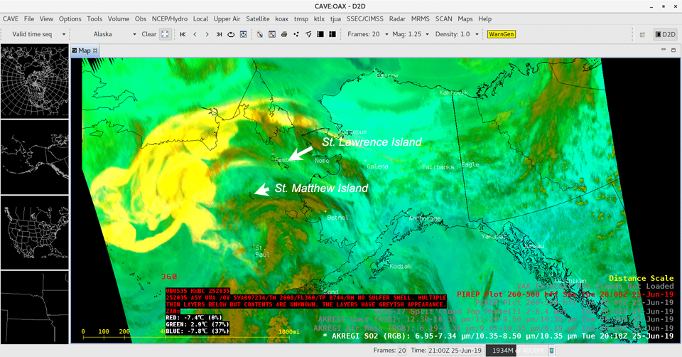 |
Figure 11. This RGB image created from a variety of spectral channels from the GOES-17 (GOES-West) satellite shows the ash and gas plume from Raikoke on 25 June 2019. The brighter yellows highlight features that are high in SO2 concentration. Highlighted along the bottom of the image is the pilot report over the far southern Bering Sea; the aircraft was flying at an altitude of 11 km (36,000 feet), and the pilot remarked that there were multiple layers seen below that altitude which had a greyish appearance (likely volcanic ash). Courtesy of NOAA and Scott Bachmeier. |
Sulfur dioxide emissions. A very large SO2 plume was released during the eruption. Preliminary total SO2 mass estimates by Simon Carn taken from both UV and IR sensors suggested around 1.4-1.5 Tg (1 Teragram = 109 Kg) that included SO2 columns within the ash plume with values as high as 1,000 Dobson Units (DU) (figure 12). As the plume drifted on 23 and 24 June, similar to the ash plume as described by the Tokyo VAAC, it moved in a circular flow pattern as a result of being entrained in a low-pressure system in the western Bering Sea (figure 13). By 25 June the NW edge of the SO2 had reached far eastern Russia, 1,700 km from the volcano (as described by KVERT), while the eastern edges reached across Alaska and the Gulf of Alaska to the S. Two days later streams of SO2 from Raikoke were present over far northern Siberia and northern Canada (figure 14). For the following three weeks high levels of SO2 persisted over far eastern Russia and the Bering Sea, demonstrating the close relationship between the prevailing weather patterns and the aerosol concentrations from the volcano (figure 15).
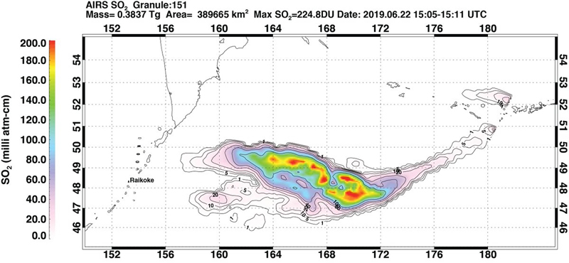 |
Figure 12. A contour map showing the mass and density of SO2 released into the atmosphere from Raikoke on 22 June 2019. Courtesy of Simon Carn. |
 |
Figure 13. Streams of SO2 from Raikoke drifted around a complex flow pattern in the Bering Sea on 23 and 24 June 2019. Data from TROPOMI instrument on the Sentinel-5P satellite, courtesy of NASA Goddard Space Flight Center and Simon Carn. |
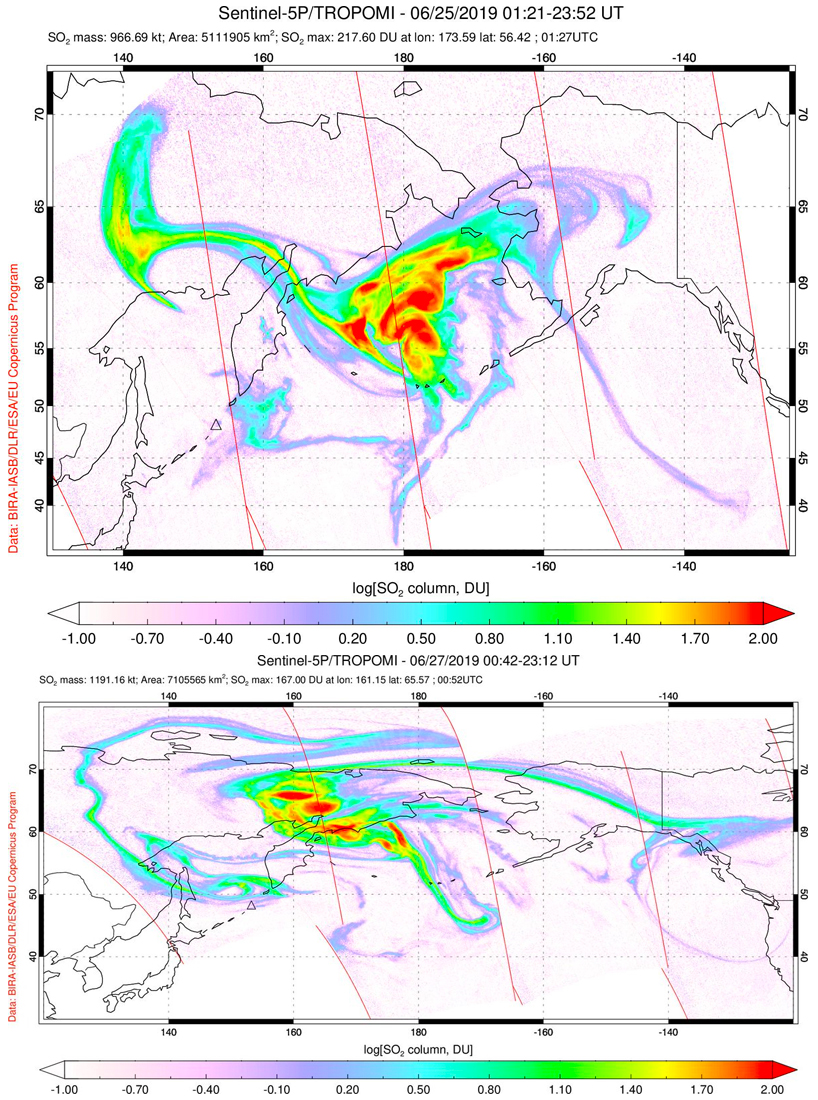 |
Figure 14. SO2 plumes from Raikoke dispersed over a large area of the northern hemisphere in late June 2019. By 25 June (top) the SO2 plumes had dispersed to far eastern Russia, 1,700 km from the volcano, while the eastern edges reached across Alaska and the Gulf of Alaska to the S. By 27 June (bottom) streams of SO2 were present over far northern Siberia and northern Canada, and also continued to circulate in a denser mass over far eastern Russia. Data from TROPOMI instrument on the Sentinel-5P satellite, courtesy of NASA Goddard Space Flight Center and Simon Carn. |
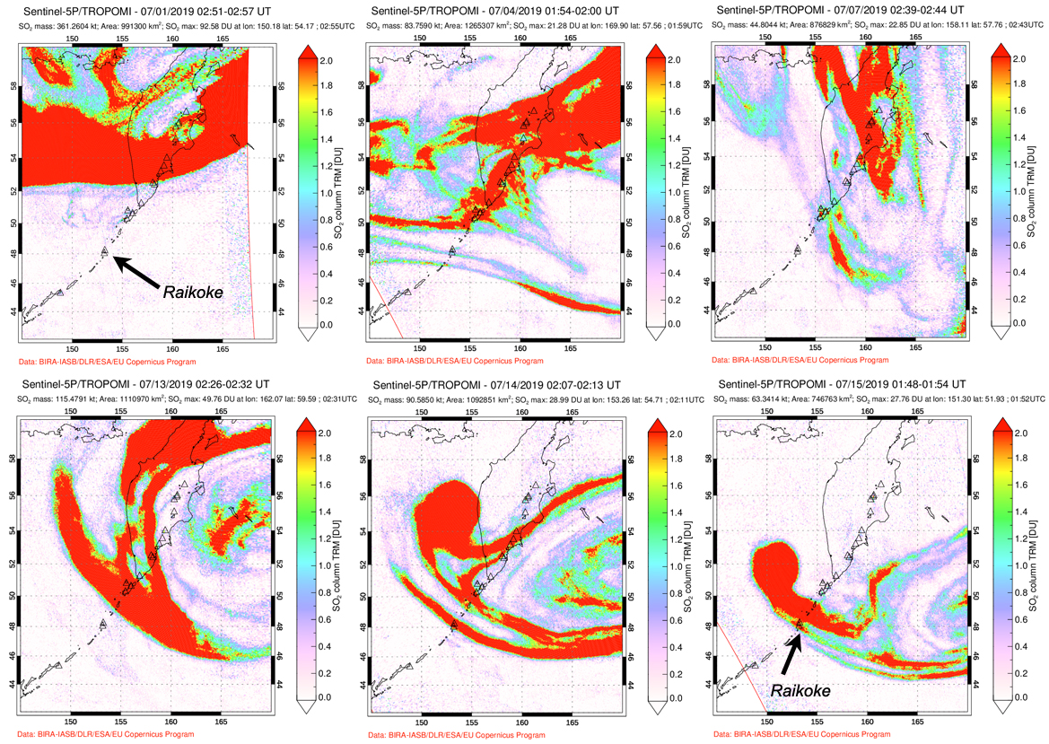 |
Figure 15. For the first two weeks of July 2019, high levels of SO2 from the 21 June 2019 eruption of Raikoke persisted over far eastern Russia and the Bering Sea entrained in a slow moving low-pressure system, demonstrating the close relationship between the prevailing weather patterns and the aerosol concentrations from the volcano. Data from TROPOMI instrument on the Sentinel-5P satellite, courtesy of NASA Goddard Space Flight Center. |
Changes to the island. Since no known activity had occurred at Raikoke for 95 years, the island was well vegetated on most of its slopes and the inner walls of the summit crater before the explosion (figure 16). The first clear satellite image after the explosion, on 30 June 2019, revealed a modest steam plume rising from the summit crater, pale-colored ash surrounding the entire island, and new deposits of debris fans extending out from the NE, SW, and S flanks. Part of a newly enlarged crater was visible at the N edge of the old crater. Two weeks later only a small steam plume was present at the summit, making the outline of the enlarged crater more visible; the extensive shoreline deposits of fresh volcanic material remained. A clear view into the summit crater on 23 July revealed the size and shape of the newly enlarged summit crater (figure 17).
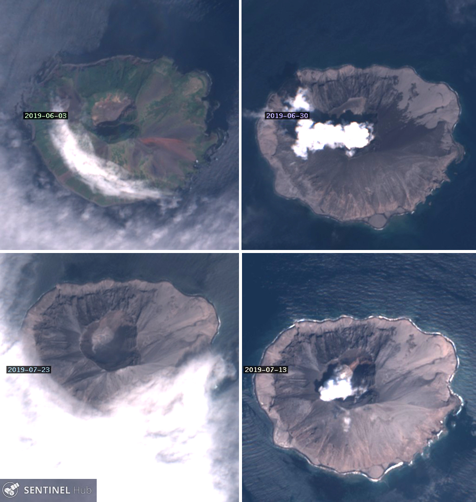 |
Figure 16. Changes at Raikoke before and after the 21 June 2019 eruption were clear in Sentinel-2 satellite imagery. The island was heavily vegetated on most of its slopes and the inner walls of the summit crater before the explosion (top left, 3 June 2019). The first clear satellite image after the explosion, on 30 June 2019 revealed a steam plume rising from the summit crater, pale-colored ash surrounding the entire island, and new deposits of debris fans extending out from the NE, SW, and S flanks (top right). Part of a newly enlarged crater was visible at the N edge of the old crater. Two weeks later only a small steam plume was present at the summit, making the outline of the enlarged crater more visible; the extensive shoreline deposits of fresh volcanic material remained (bottom right, 13 July 2019). A clear view into the summit crater on 23 July revealed the new size and shape of the summit crater (bottom left). Natural Color rendering (bands 4, 3, 2), courtesy of Sentinel Hub Playground. |
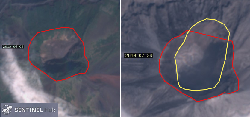 |
Figure 17. Sentinel-2 satellite imagery of the summit crater of Raikoke before (left) and after (right) the explosions that began on 21 June 2019. The old crater rim is outlined in red in both images. The new crater rim is outlined in yellow in the 23 July image. Natural Color rendering (bands 4, 3, 2), courtesy of Sentinel Hub Playground. |
References: Gorshkov G S, 1970, Volcanism and the Upper Mantle; Investigations in the Kurile Island Arc, New York: Plenum Publishing Corp, 385 p.
Tanakadate H, 1925, The volcanic activity in Japan during 1914-1924, Bull Volc. v. 1, no. 3.
Information Contacts: Institute of Volcanology and Seismology, Far Eastern Branch, Russian Academy of Sciences (IVS FEB RAS), 9 Piip Blvd., Petropavlovsk-Kamchatsky 683006, Russia (URL: http://www.kscnet.ru/ivs/eng/); Sakhalin Volcanic Eruption Response Team (SVERT), Institute of Marine Geology and Geophysics, Far Eastern Branch, Russian Academy of Science, Nauki st., 1B, Yuzhno-Sakhalinsk, Russia, 693022 (URL: http://www.imgg.ru/en/, http://www.imgg.ru/ru/svert/reports); Kamchatka Volcanic Eruptions Response Team (KVERT), Far Eastern Branch, Russian Academy of Sciences, 9 Piip Blvd., Petropavlovsk-Kamchatsky, 683006, Russia (URL: http://www.kscnet.ru/ivs/kvert/); NASA Earth Observatory, EOS Project Science Office, NASA Goddard Space Flight Center, Goddard, Maryland, USA (URL: http://earthobservatory.nasa.gov/); Global Sulfur Dioxide Monitoring Page, Atmospheric Chemistry and Dynamics Laboratory, NASA Goddard Space Flight Center (NASA/GSFC), 8800 Greenbelt Road, Goddard, Maryland, USA (URL: https://so2.gsfc.nasa.gov/); Sentinel Hub Playground (URL: https://www.sentinel-hub.com/explore/sentinel-playground); NOAA, Cooperative Institute for Meteorological Satellite Studies (CIMSS), Space Science and Engineering Center (SSEC), University of Wisconsin-Madison, 1225 W. Dayton St. Madison, WI 53706, (URL: http://cimss.ssec.wisc.edu/); Simon Carn, Geological and Mining Engineering and Sciences, Michigan Technological University, 1400 Townsend Drive, Houghton, MI 49931, USA (URL: http://www.volcarno.com/, Twitter: @simoncarn); Scott Bachmeier, Cooperative Institute for Meteorological Satellite Studies (CIMSS), Space Science and Engineering Center (SSEC), University of Wisconsin-Madison, 1225 W. Dayton St. Madison, WI 53706; Flightradar24 (URL: https://www.flightradar24.com/51,-2/6); Volcano Discovery (URL: http://www.volcanodiscovery.com/).
2019: June
SVERT and KVERT reported that during 25 June-1 July steam-and-gas plumes with ash rose 1.5-2 km above Raikoke and drifted WNW based on satellite images. The Aviation Color Code was lowered to Yellow on 25 June and then to Green on 27 June.
Sources: Sakhalin Volcanic Eruption Response Team (SVERT); Kamchatkan Volcanic Eruption Response Team (KVERT)
A powerful eruption at Raikoke that began on 22 June (after 95 years of dormancy) was identified based on satellite observations, prompting KVERT and SVERT to raise the Aviation Color Code to Red. A series of at least nine explosions (six within the first 25 minutes) beginning at 0505 and continuing to about 1900 produced ash plumes, with a significant sulfur dioxide component, that rose 10-13 km (32,800-42,700 ft) a.s.l. and drifted E and NE. Lightning was detected in the eruption plumes. Strong explosions at 1640 on 22 June generated ash plumes that rose to 10-11 km (32,800-36,100 ft) a.s.l. The ash and gas was entrained by jet streams and by a cyclone around the Komandorskiye Islands, causing parts of the material to spiral counterclockwise as it drifted farther NE. By 23 June the leading edge of the plume had drifted 2,000 km ENE. According to a news article, at least 40 flights in that region were diverted.
On 23 June ash plumes continued to be visible, rising to 4.5 km and drifting NE. The Aviation Color Code was lowered to Orange. Gas-and-steam plumes possibly with some ash rose to 4.5 km (14,800 ft) a.s.l. and drifted 60 km NW. That same day observers on a passing ship approached the island from the W side; they photographed the island and sent out a drone. An expedition member noted that the entire island was mantled with light-colored ash deposits up to several dozen centimeters thick. In some of the drainages and at the base of some drainages deposits were several meters thick. In some areas along the shoreline waves interacted with the deposits, causing steam explosions and dark brown steam emissions. Gas-and-ash plumes rose 1.5 km above the summit crater rim and drifted W. Minor ashfall was reported in Severo-Kurilsk (340 km NE) during 1830-1920. On 25 June ash plumes continued to be produced, rising as high as 2 km (6,600 ft) a.s.l. and drifting NW.
Sources: Sakhalin Volcanic Eruption Response Team (SVERT); Kamchatkan Volcanic Eruption Response Team (KVERT); NHK (Japan Broadcasting Corporation)
Reports are organized chronologically and indexed below by Month/Year (Publication Volume:Number), and include a one-line summary. Click on the index link or scroll down to read the reports.
Short-lived series of large explosions 21-23 June 2019; first recorded activity in 95 years
Raikoke in the central Kuril Islands lies 400 km SW of the southern tip of Russia's Kamchatcka Peninsula. Two significant eruptive events in historical times, including fatalities, have been recorded. In 1778 an eruption killed 15 people "under the hail of bombs" who were under the command of Captain Chernyi, returning from Matua to Kamchatka. This prompted the Russian military to order the first investigation of the volcanic character of the island two years later (Gorshkov, 1970). Tanakadate (1925) reported that travelers on a steamer witnessed an ash plume rising from the island on 15 February 1924, observed that the island was already covered in ash from recent activity, and noted that a dense steam plume was visible for a week rising from the summit crater. The latest eruptive event in June 2019 produced a very large ash plume that covered the island with ash and dispersed ash and gases more than 10 km high into the atmosphere. The volcano is monitored by the Sakhalin Volcanic Eruption Response Team, (SVERT) part of the Institute of Marine Geology and Geophysics, Far Eastern Branch of the Russian Academy of Sciences (IMGG FEB RAS) and the Kamchatka Volcanic Eruption Response Team (KVERT) which is part of the Institute of Volcanology and Seismology, Far Eastern Branch of the Russian Academy of Sciences (IVS FEB RAS).
A brief but intense eruption beginning on 21 June 2019 sent major ash and sulfur dioxide plumes into the stratosphere (figures 1 and 2); the plumes rapidly drifted over 1,000 km from the volcano. Strong explosions with dense ash plumes lasted for less than 48 hours, minor emissions continued for a few more days; the SO2, however, continued to circulate over far eastern Russia and the Bering Sea for more than three weeks after the initial explosion. The eruption covered the island with centimeters to meters of ash and enlarged the summit crater. By the end of July 2019 only minor intermittent steam emissions were observed in satellite imagery.
|
Figure 1. On the morning of 22 June 2019, astronauts on the International Space Station captured this image of a large ash plume rising from Raikoke in the Kuril Islands. The plume reached altitudes of 10-13 km and drifted E during the volcano's first known explosion in 95 years. Courtesy of NASA Earth Observatory. |
|
Figure 2. A large and very dense SO2 plume (measuring over 900 Dobson Units (DU)) drifted E from Raikoke in the Kuril Islands on 22 June 2019, about 8 hours after the first known explosion in 95 years. Courtesy of NASA Goddard Space Flight Center. |
Summary of 2019 activity. A powerful eruption at Raikoke began at 1805 on 21 June 2019 (UTC). Volcano Observatory Notices for Aviation (VONA's) issued by KVERT described the large ash plume that rapidly rose to 10-13 km altitude and extended for 370 km NE within the first two hours (figure 3). After eight hours, the plume extended 605 km ENE; it had reached 1,160 km E by 13 hours after the first explosion (figure 4). The last strong explosive event, according to KVERT, producing an ash column as high as 10-11 km, occurred at 0540 UTC on 22 June. SVERT reported a series of nine explosions during the eruption. Over 440 lightning events within the ash plume were detected in the first 24 hours by weather-monitoring equipment. The Japanese Ministry of Transportation reported that almost 40 planes were diverted because of the ash plume (figure 5).
|
Figure 3. A dense ash plume drifted E from Raikoke on 22 June 2019 from a series of large explosions that lasted for less than 24 hours, as seen in this Terra satellite image. The plume was detected in the atmosphere for several days after the end of the eruptive activity. Courtesy of NASA Earth Observatory. |
|
Figure 4. The ash plume from Raikoke volcano that erupted on 21 June 2019 drifted over 1,000 km E by late in the day on 22 June, as seen in this oblique, composite view based on data from the Visible Infrared Imaging Radiometer Suite (VIIRS) on the Suomi NPP satellite. Courtesy of NASA Earth Observatory. |
|
Figure 5. Numerous airplanes were traveling on flight paths near the Raikoke ash plume (black streak at center) early on 22 June 2019. The Japanese Ministry of Transportation reported that almost 40 planes were diverted because of the plume. Courtesy of Flightradar24 and Volcano Discovery. |
On 23 June (local time) the cruise ship Athena approached the island; expedition member Nikolai Pavlov provided an eyewitness account and took remarkable drone photographs of the end of the eruption. The ship approached the W flank of the island in the late afternoon and they were able to launch a drone and photograph the shore and the summit. They noted that the entire surface of the island was covered with a thick layer of light-colored ash up to several tens of centimeters thick (figure 6). Fresh debris up to several meters thick fanned out from the base of the slopes (figure 7). The water had a yellowish-greenish tint and was darker brown closer to the shore. Dark-brown steam explosions occurred when waves flowed over hot areas along the shoreline, now blanketed in pale ash with bands of steam and gas rising from it (figure 8). A dense brown ash plume drifted W from the crater, rising about 1.5 km above the summit (figure 9).
|
Figure 6. The entire surface of the island of Raikoke was covered with a thick layer of light-colored ash up to several tens of centimeters thick on 23 June 2019 when photographed by drone from the cruise ship Athena about 36 hours after the explosions began. View is of the W flank. Photo by Nik Pavlov; courtesy of IVS FEB RAS. |
|
Figure 7. Fresh ash and volcanic debris up to several meters thick coated the flanks of Raikoke on 23 June 2019 after the large explosive eruption two days earlier. View is by drone of the W flank. Photo by Nik Pavlov; courtesy of IVS FEB RAS. |
|
Figure 8. The 21 June 2019 eruption of Raikoke covered the island in volcanic debris. The formerly vegetated areas (left, before eruption) were blanketed in pale ash with bands of steam and gas rising all along the shoreline (right, on 23 June 2019) less than two days after the explosions began. The open water area between the sea stack and the island was filled with tephra. Photos by Nik Pavlov; courtesy of IVS FEB RAS. |
|
Figure 9. At the summit of Raikoke on 23 June 2019, a dense brown ash plume drifted W from the crater, rising about 1.5 km, two days after a large explosive eruption. Drone photo by Nik Pavlov; courtesy of IVS FEB RAS. |
Early on 23 June, the large ash cloud continued to drift E and then NE at an altitude of 10-13 km. At that altitude, the leading edge of the ash cloud became entrained in a large low pressure system and began rotating from SE to NW, centered in the area of the Komandorskiye Islands, 1,200 km NE of Raikoke. By then the farthest edge of ash plume was located about 2,000 km ENE of the volcano. Meanwhile, at the summit and immediately above, the ash plume was drifting NW on 23 June (figures 9 and 10). Ashfall was reported (via Twitter) from a ship in the Pacific Ocean 40 km from Raikoke on 23 June. Weak ashfall was also reported in Paramushir, over 300 km NE the same day. KVERT reported that satellite data from 25 June indicated that a steam and gas plume, possibly with some ash, extended for 60 km NW. They also noted that the high-altitude "aerosol cloud" continued to drift to the N and W, reaching a distance of 1,700 km NW (see SO2 discussion below). By 27 June KVERT reported that the eruption had ended, but the aerosols continued to drift to the NW and E. They lowered the Aviation Alert Level to Green the following day.
|
Figure 10. The brown ash plume from Raikoke was drifting NW on 23 June 2019 (left), while the remnants of the ash from the earlier explosions continued to be observed over a large area to the NE on 25 June (right). The plume in the 23 June image extends about 30 km NW; the plume in the 25 June image extends a similar distance NE. Natural color rendering (bands 4, 3, 2) of Sentinel-2 imagery, courtesy of Sentinel Hub Playground. |
Tokyo and Anchorage VAAC Reports. The Tokyo VAAC first observed the ash plume in satellite imagery at 10.4 km altitude at 1850 on 21 June 209, just under an hour after the explosion was first reported by KVERT. About four hours later they updated the altitude to 13.1 km based on satellite data and a pilot report. By the evening of 22 June the high-level ash plume was still drifting ESE at about 13 km altitude while a secondary plume at 4.6 km altitude drifted SE for a few more hours before dissipating. The direction of the high-altitude plume began to shift to the NNW by 0300 on 23 June. By 0900 it had dropped slightly to 12.2 km and was drifting NE. The Anchorage VAAC reported at 2030 that the ash plume was becoming obscured by meteorological clouds around a large and deep low-pressure system in the western Bering Sea. Ash and SO2 signals in satellite imagery remained strong over the region S and W of the Pribilof Islands as well as over the far western Bering Sea adjacent to Russia. By early on 24 June the plume drifted NNW for a few hours before rotating back again to a NE drift direction. By the afternoon of 24 June, the altitude had dropped slightly to 11.6 km as it continued to drift NNE.
The ash plume was still clearly visible in satellite imagery late on 24 June. An aircraft reported SO2 at 14.3 km altitude above the area of the ash plume. The plume then began to move in multiple directions; the northern part moved E, while the southern part moved N. The remainder was essentially stationary, circulating around a closed low-pressure zone in the western Bering Sea. The ash plume remained stationary and slowly dissipated as it circulated around the low through 25 June before beginning to push S (figure 11). By early on 26 June the main area of the ash plume was between 325 km WSW of St. Matthew Island and 500 km NNW of St. Lawrence Island, and moving slowly NW. The Anchorage VAAC could no longer detect the plume in satellite imagery shortly after midnight (UTC) on 27 June, although they noted that areas of aerosol haze and SO2 likely persisted over the western Bering Sea and far eastern Russia.
|
Figure 11. This RGB image created from a variety of spectral channels from the GOES-17 (GOES-West) satellite shows the ash and gas plume from Raikoke on 25 June 2019. The brighter yellows highlight features that are high in SO2 concentration. Highlighted along the bottom of the image is the pilot report over the far southern Bering Sea; the aircraft was flying at an altitude of 11 km (36,000 feet), and the pilot remarked that there were multiple layers seen below that altitude which had a greyish appearance (likely volcanic ash). Courtesy of NOAA and Scott Bachmeier. |
Sulfur dioxide emissions. A very large SO2 plume was released during the eruption. Preliminary total SO2 mass estimates by Simon Carn taken from both UV and IR sensors suggested around 1.4-1.5 Tg (1 Teragram = 109 Kg) that included SO2 columns within the ash plume with values as high as 1,000 Dobson Units (DU) (figure 12). As the plume drifted on 23 and 24 June, similar to the ash plume as described by the Tokyo VAAC, it moved in a circular flow pattern as a result of being entrained in a low-pressure system in the western Bering Sea (figure 13). By 25 June the NW edge of the SO2 had reached far eastern Russia, 1,700 km from the volcano (as described by KVERT), while the eastern edges reached across Alaska and the Gulf of Alaska to the S. Two days later streams of SO2 from Raikoke were present over far northern Siberia and northern Canada (figure 14). For the following three weeks high levels of SO2 persisted over far eastern Russia and the Bering Sea, demonstrating the close relationship between the prevailing weather patterns and the aerosol concentrations from the volcano (figure 15).
|
Figure 12. A contour map showing the mass and density of SO2 released into the atmosphere from Raikoke on 22 June 2019. Courtesy of Simon Carn. |
|
Figure 13. Streams of SO2 from Raikoke drifted around a complex flow pattern in the Bering Sea on 23 and 24 June 2019. Data from TROPOMI instrument on the Sentinel-5P satellite, courtesy of NASA Goddard Space Flight Center and Simon Carn. |
|
Figure 14. SO2 plumes from Raikoke dispersed over a large area of the northern hemisphere in late June 2019. By 25 June (top) the SO2 plumes had dispersed to far eastern Russia, 1,700 km from the volcano, while the eastern edges reached across Alaska and the Gulf of Alaska to the S. By 27 June (bottom) streams of SO2 were present over far northern Siberia and northern Canada, and also continued to circulate in a denser mass over far eastern Russia. Data from TROPOMI instrument on the Sentinel-5P satellite, courtesy of NASA Goddard Space Flight Center and Simon Carn. |
|
Figure 15. For the first two weeks of July 2019, high levels of SO2 from the 21 June 2019 eruption of Raikoke persisted over far eastern Russia and the Bering Sea entrained in a slow moving low-pressure system, demonstrating the close relationship between the prevailing weather patterns and the aerosol concentrations from the volcano. Data from TROPOMI instrument on the Sentinel-5P satellite, courtesy of NASA Goddard Space Flight Center. |
Changes to the island. Since no known activity had occurred at Raikoke for 95 years, the island was well vegetated on most of its slopes and the inner walls of the summit crater before the explosion (figure 16). The first clear satellite image after the explosion, on 30 June 2019, revealed a modest steam plume rising from the summit crater, pale-colored ash surrounding the entire island, and new deposits of debris fans extending out from the NE, SW, and S flanks. Part of a newly enlarged crater was visible at the N edge of the old crater. Two weeks later only a small steam plume was present at the summit, making the outline of the enlarged crater more visible; the extensive shoreline deposits of fresh volcanic material remained. A clear view into the summit crater on 23 July revealed the size and shape of the newly enlarged summit crater (figure 17).
|
Figure 16. Changes at Raikoke before and after the 21 June 2019 eruption were clear in Sentinel-2 satellite imagery. The island was heavily vegetated on most of its slopes and the inner walls of the summit crater before the explosion (top left, 3 June 2019). The first clear satellite image after the explosion, on 30 June 2019 revealed a steam plume rising from the summit crater, pale-colored ash surrounding the entire island, and new deposits of debris fans extending out from the NE, SW, and S flanks (top right). Part of a newly enlarged crater was visible at the N edge of the old crater. Two weeks later only a small steam plume was present at the summit, making the outline of the enlarged crater more visible; the extensive shoreline deposits of fresh volcanic material remained (bottom right, 13 July 2019). A clear view into the summit crater on 23 July revealed the new size and shape of the summit crater (bottom left). Natural Color rendering (bands 4, 3, 2), courtesy of Sentinel Hub Playground. |
|
Figure 17. Sentinel-2 satellite imagery of the summit crater of Raikoke before (left) and after (right) the explosions that began on 21 June 2019. The old crater rim is outlined in red in both images. The new crater rim is outlined in yellow in the 23 July image. Natural Color rendering (bands 4, 3, 2), courtesy of Sentinel Hub Playground. |
References: Gorshkov G S, 1970, Volcanism and the Upper Mantle; Investigations in the Kurile Island Arc, New York: Plenum Publishing Corp, 385 p.
Tanakadate H, 1925, The volcanic activity in Japan during 1914-1924, Bull Volc. v. 1, no. 3.
Information Contacts: Institute of Volcanology and Seismology, Far Eastern Branch, Russian Academy of Sciences (IVS FEB RAS), 9 Piip Blvd., Petropavlovsk-Kamchatsky 683006, Russia (URL: http://www.kscnet.ru/ivs/eng/); Sakhalin Volcanic Eruption Response Team (SVERT), Institute of Marine Geology and Geophysics, Far Eastern Branch, Russian Academy of Science, Nauki st., 1B, Yuzhno-Sakhalinsk, Russia, 693022 (URL: http://www.imgg.ru/en/, http://www.imgg.ru/ru/svert/reports); Kamchatka Volcanic Eruptions Response Team (KVERT), Far Eastern Branch, Russian Academy of Sciences, 9 Piip Blvd., Petropavlovsk-Kamchatsky, 683006, Russia (URL: http://www.kscnet.ru/ivs/kvert/); NASA Earth Observatory, EOS Project Science Office, NASA Goddard Space Flight Center, Goddard, Maryland, USA (URL: http://earthobservatory.nasa.gov/); Global Sulfur Dioxide Monitoring Page, Atmospheric Chemistry and Dynamics Laboratory, NASA Goddard Space Flight Center (NASA/GSFC), 8800 Greenbelt Road, Goddard, Maryland, USA (URL: https://so2.gsfc.nasa.gov/); Sentinel Hub Playground (URL: https://www.sentinel-hub.com/explore/sentinel-playground); NOAA, Cooperative Institute for Meteorological Satellite Studies (CIMSS), Space Science and Engineering Center (SSEC), University of Wisconsin-Madison, 1225 W. Dayton St. Madison, WI 53706, (URL: http://cimss.ssec.wisc.edu/); Simon Carn, Geological and Mining Engineering and Sciences, Michigan Technological University, 1400 Townsend Drive, Houghton, MI 49931, USA (URL: http://www.volcarno.com/, Twitter: @simoncarn); Scott Bachmeier, Cooperative Institute for Meteorological Satellite Studies (CIMSS), Space Science and Engineering Center (SSEC), University of Wisconsin-Madison, 1225 W. Dayton St. Madison, WI 53706; Flightradar24 (URL: https://www.flightradar24.com/51,-2/6); Volcano Discovery (URL: http://www.volcanodiscovery.com/).
|
|
||||||||||||||||||||||||||
There is data available for 4 confirmed eruptive periods.
2019 Jun 22 - 2019 Jul 1 Confirmed Eruption (Explosive / Effusive) VEI: 3
| Episode 1 | Eruption (Explosive / Effusive) | ||||||||||||||
|---|---|---|---|---|---|---|---|---|---|---|---|---|---|---|
| 2019 Jun 22 - 2019 Jul 1 | Evidence from Observations: Reported | |||||||||||||
|
List of 1 Events for Episode 1
|
||||||||||||||
1924 Feb 14 (?) - 1924 Feb 15 Confirmed Eruption (Explosive / Effusive) VEI: 4
| Episode 1 | Eruption (Explosive / Effusive) | |||||||||||||||||||
|---|---|---|---|---|---|---|---|---|---|---|---|---|---|---|---|---|---|---|---|
| 1924 Feb 14 (?) - 1924 Feb 15 | Evidence from Observations: Reported | ||||||||||||||||||
|
List of 2 Events for Episode 1
|
|||||||||||||||||||
1778 Confirmed Eruption (Explosive / Effusive) VEI: 4
| Episode 1 | Eruption (Explosive / Effusive) | ||||||||||||||||||||||||||||||||||
|---|---|---|---|---|---|---|---|---|---|---|---|---|---|---|---|---|---|---|---|---|---|---|---|---|---|---|---|---|---|---|---|---|---|---|
| 1778 - Unknown | Evidence from Observations: Reported | |||||||||||||||||||||||||||||||||
|
List of 5 Events for Episode 1
|
||||||||||||||||||||||||||||||||||
1765 ± 5 years Confirmed Eruption (Explosive / Effusive) VEI: 2
| Episode 1 | Eruption (Explosive / Effusive) | |||||||||||||||||||
|---|---|---|---|---|---|---|---|---|---|---|---|---|---|---|---|---|---|---|---|
| 1765 ± 5 years - Unknown | Evidence from Observations: Reported | ||||||||||||||||||
|
List of 2 Events for Episode 1
|
|||||||||||||||||||
This compilation of synonyms and subsidiary features may not be comprehensive. Features are organized into four major categories: Cones, Craters, Domes, and Thermal Features. Synonyms of features appear indented below the primary name. In some cases additional feature type, elevation, or location details are provided.
Synonyms |
| Rakhohkko | Raikoketo | Raukoke | Raykoke | Ralkokeshima | Raikoku |
There are no samples for Raikoke in the Smithsonian's NMNH Department of Mineral Sciences Rock and Ore collection.
| Copernicus Browser | The Copernicus Browser replaced the Sentinel Hub Playground browser in 2023, to provide access to Earth observation archives from the Copernicus Data Space Ecosystem, the main distribution platform for data from the EU Copernicus missions. |
| MIROVA | Middle InfraRed Observation of Volcanic Activity (MIROVA) is a near real time volcanic hot-spot detection system based on the analysis of MODIS (Moderate Resolution Imaging Spectroradiometer) data. In particular, MIROVA uses the Middle InfraRed Radiation (MIR), measured over target volcanoes, in order to detect, locate and measure the heat radiation sourced from volcanic activity. |
| MODVOLC Thermal Alerts | Using infrared satellite Moderate Resolution Imaging Spectroradiometer (MODIS) data, scientists at the Hawai'i Institute of Geophysics and Planetology, University of Hawai'i, developed an automated system called MODVOLC to map thermal hot-spots in near real time. For each MODIS image, the algorithm automatically scans each 1 km pixel within it to check for high-temperature hot-spots. When one is found the date, time, location, and intensity are recorded. MODIS looks at every square km of the Earth every 48 hours, once during the day and once during the night, and the presence of two MODIS sensors in space allows at least four hot-spot observations every two days. Each day updated global maps are compiled to display the locations of all hot spots detected in the previous 24 hours. There is a drop-down list with volcano names which allow users to 'zoom-in' and examine the distribution of hot-spots at a variety of spatial scales. |
|
WOVOdat
Single Volcano View Temporal Evolution of Unrest Side by Side Volcanoes |
WOVOdat is a database of volcanic unrest; instrumentally and visually recorded changes in seismicity, ground deformation, gas emission, and other parameters from their normal baselines. It is sponsored by the World Organization of Volcano Observatories (WOVO) and presently hosted at the Earth Observatory of Singapore.
GVMID Data on Volcano Monitoring Infrastructure The Global Volcano Monitoring Infrastructure Database GVMID, is aimed at documenting and improving capabilities of volcano monitoring from the ground and space. GVMID should provide a snapshot and baseline view of the techniques and instrumentation that are in place at various volcanoes, which can be use by volcano observatories as reference to setup new monitoring system or improving networks at a specific volcano. These data will allow identification of what monitoring gaps exist, which can be then targeted by remote sensing infrastructure and future instrument deployments. |
| Volcanic Hazard Maps | The IAVCEI Commission on Volcanic Hazards and Risk has a Volcanic Hazard Maps database designed to serve as a resource for hazard mappers (or other interested parties) to explore how common issues in hazard map development have been addressed at different volcanoes, in different countries, for different hazards, and for different intended audiences. In addition to the comprehensive, searchable Volcanic Hazard Maps Database, this website contains information about diversity of volcanic hazard maps, illustrated using examples from the database. This site is for educational purposes related to volcanic hazard maps. Hazard maps found on this website should not be used for emergency purposes. For the most recent, official hazard map for a particular volcano, please seek out the proper institutional authorities on the matter. |
| IRIS seismic stations/networks | Incorporated Research Institutions for Seismology (IRIS) Data Services map showing the location of seismic stations from all available networks (permanent or temporary) within a radius of 0.18° (about 20 km at mid-latitudes) from the given location of Raikoke. Users can customize a variety of filters and options in the left panel. Note that if there are no stations are known the map will default to show the entire world with a "No data matched request" error notice. |
| UNAVCO GPS/GNSS stations | Geodetic Data Services map from UNAVCO showing the location of GPS/GNSS stations from all available networks (permanent or temporary) within a radius of 20 km from the given location of Raikoke. Users can customize the data search based on station or network names, location, and time window. Requires Adobe Flash Player. |
| DECADE Data | The DECADE portal, still in the developmental stage, serves as an example of the proposed interoperability between The Smithsonian Institution's Global Volcanism Program, the Mapping Gas Emissions (MaGa) Database, and the EarthChem Geochemical Portal. The Deep Earth Carbon Degassing (DECADE) initiative seeks to use new and established technologies to determine accurate global fluxes of volcanic CO2 to the atmosphere, but installing CO2 monitoring networks on 20 of the world's 150 most actively degassing volcanoes. The group uses related laboratory-based studies (direct gas sampling and analysis, melt inclusions) to provide new data for direct degassing of deep earth carbon to the atmosphere. |
| Large Eruptions of Raikoke | Information about large Quaternary eruptions (VEI >= 4) is cataloged in the Large Magnitude Explosive Volcanic Eruptions (LaMEVE) database of the Volcano Global Risk Identification and Analysis Project (VOGRIPA). |
| EarthChem | EarthChem develops and maintains databases, software, and services that support the preservation, discovery, access and analysis of geochemical data, and facilitate their integration with the broad array of other available earth science parameters. EarthChem is operated by a joint team of disciplinary scientists, data scientists, data managers and information technology developers who are part of the NSF-funded data facility Integrated Earth Data Applications (IEDA). IEDA is a collaborative effort of EarthChem and the Marine Geoscience Data System (MGDS). |


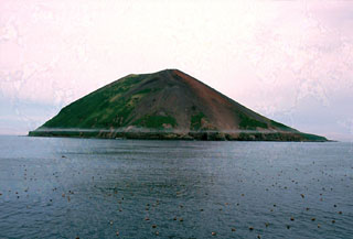 Raikoke Island, seen here from the SE, lies 50 km SW of Shiashkotan Island and 16 km across the Golovnin Strait to the NE of its closest neighboring volcano on Matua Island. The island is only 2 x 2.5 km wide and rises about 550 m above the ocean; a submarine terrace is at a depth of 130 m. A catastrophic eruption in 1778 prompted the first volcanological investigation in the Kuril Islands two years later.